High Sierra Trail History and Origins
Designated a national park to protect the endangered sequoias of Giant Forest and nearby groves from sheepherders and loggers, Sequoia National Park’s backcountry was initially an inaccessible afterthought. Soon after the park was enlarged to include Mt. Whitney and Kern Canyon, a group of businessmen proposed building a road from Lake Isabella in Kern County to Yosemite National Park. If you’d like a deeper look at why these groves were protected and what makes Sequoia National Park so extraordinary, my What Is So Special About Sequoia National Park? guide explores the giant sequoias, their history, and the significance of places like Giant Forest.
Initially, park superintendent James White supported the highway—known as the Sierra Way—but by the 1930s, his stance had shifted, and he opposed the road. Around the same time, he ordered the construction of the High Sierra Way, a 72‑mile trail from Giant Forest to Mount Whitney. This was perhaps a compromise: providing public access to the park’s eastern side without the intrusion of vehicle engines in the wilderness.
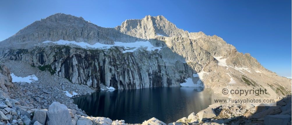
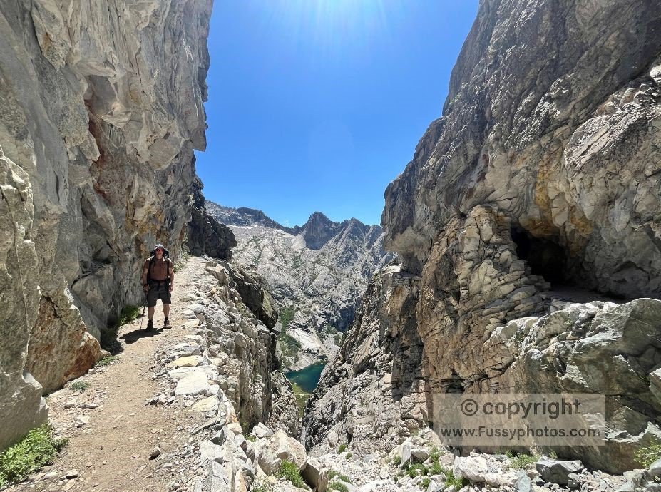
The aim of the High Sierra Trail was to allow access while minimizing damage to the wilderness and keeping elevation changes manageable, with a maximum grade of 8%. To achieve this, part of the trail between Bearpaw Meadow and Kaweah Gap was blasted directly into granite cliffs. An image of this tunnel, carved high above Hamilton Lakes, instantly placed the High Sierra Trail—at least this section—on my bucket list.
Note: This trip report was originally published as the High Sierra Trail Loop. I now use the name Hamilton Basin Loop—an unofficial but more accurate description of this 5‑day circuit, which only overlaps part of the High Sierra Trail. The H1 titles remain unchanged for continuity, and readers planning their own variation of the route can find practical guidance in my Hamilton Basin Loop trip‑planning guide.
Choosing Your Hamilton Basin Loop Start Point: Mineral King vs. Lodgepole Village
Initially, I planned a route beginning in the rugged Mineral King area in the park’s southwest. Permits here are relatively easy to secure, and my intended clockwise loop would cross Timber Gap to Bearpaw Meadow, join the High Sierra Trail to Hamilton Lakes and Kaweah Gap, then loop south to Little Five Lakes before returning via Sawtooth Pass. This 3–4 day route seemed perfect for a backcountry trip.
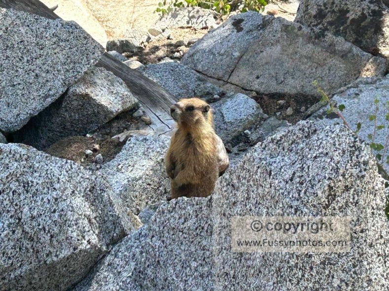
However, further research revealed a problem: marmots in the area are notorious for chewing through engine coolant lines, wires, and other car components—a fact confirmed by a ranger at the permit office. With a long desert drive to Las Vegas planned later in our trip, this was not a risk I wanted to take.
Fortunately, I had time to pivot before advanced permits were released. Plan B was to start and finish on the High Sierra Trail, avoiding both the marmots and the primitive road to Mineral King. This allowed for a departure from either Giant Forest or Wolverton. I wanted to end the hike at Giant Forest for a grand finale among the massive sequoias, so we planned to join at the less glamorous Wolverton Trailhead via Lodgepole-Sherman Tree Trail from Lodgepole Campground.
For anyone comparing Mineral King and High Sierra Trail entry points, my High Sierra Trail permits and loop alternatives guide explains the pros and cons of each, including why the Hamilton Basin Loop avoids the marmot issue entirely.
Hamilton Basin Loop Route Map
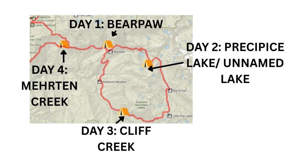
Base map courtesy of the National Park Service (NPS), annotations by Fussyphotos (Jack).
Day 1 Maps: Lodgepole to Bearpaw Meadow Campground
Day 1 elevation profile
Starting The Hamilton Basin Loop from Lodgepole
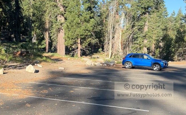
After two nights acclimatizing at Lodgepole, we decided to leave the car there in what felt like a safe, secure environment. Full of energy and enthusiasm, we weren’t concerned about the extra 1.7 miles and elevation gain this would add. If you’re spending time around Giant Forest, Wolverton, or Lodgepole before your hike, my guide to How to Spend One Unforgettable Day in Sequoia NP highlights the best short trails and viewpoints in this area.
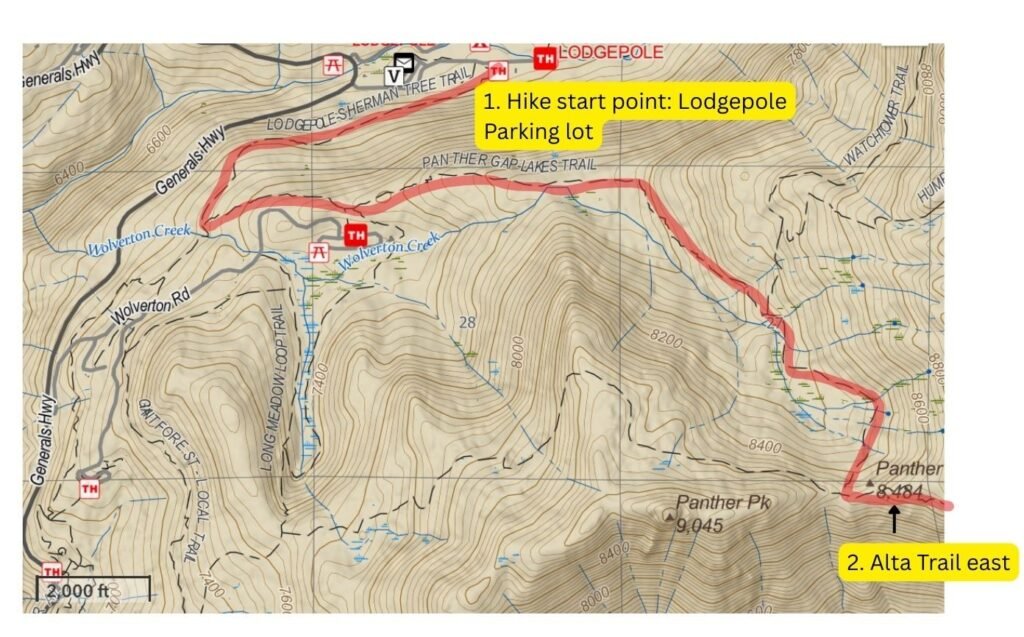
Because this is bear country, we stored all scented, nonessential items in one of the bear lockers by the parking area—common practice in the Sierra Nevada to avoid returning to a smashed‑in car. Our packs were heavy, loaded with two bear canisters and five days’ worth of food, as we set off confidently along the Lodgepole–Sherman Tree Trail.
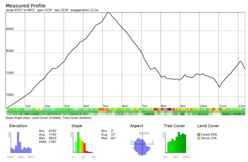
We soon turned left onto the Lakes Trail, passing Wolverton parking lot. On a previous hike here, I’d seen three bears and been bitten repeatedly by mosquitoes, but this time the start was serene. We made steady, if slow, progress, gaining 1,700 feet in the first 4.5 miles.
Panther Gap Views
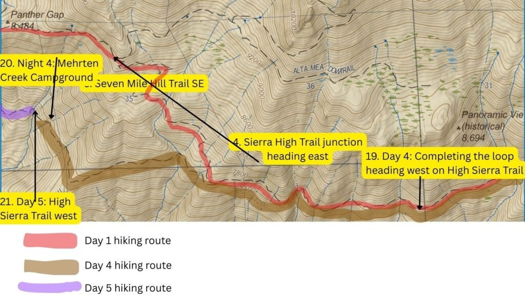
We joined the equally wooded Panther Gap Trail and continued uphill until we reached our first real vista at Panther Gap—8,600 feet above sea level and far above the valley below. Relieved to be on flatter ground, we took a break before following the contours east on the Alta Trail.
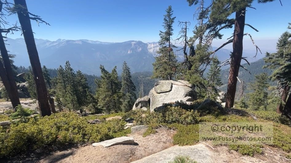
Soon, we began losing much of the elevation we’d gained as we switched to the Seven Mile Hill Trail, heading southeast toward the High Sierra Trail. Snow‑capped peaks appeared in the distance—some we’d see up close in the days ahead.

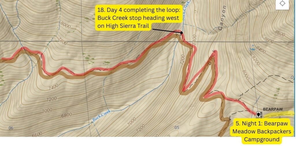
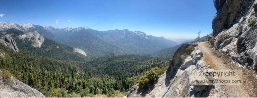
Although lower in elevation, the High Sierra Trail offered excellent vantage points of the valley below, though often obscured by trees. The real thrill came when the trail opened up to expansive views along narrow ledges high above the forest. The most dramatic section was where the trail had been blasted into the rock, with the valley walls overhanging above us.
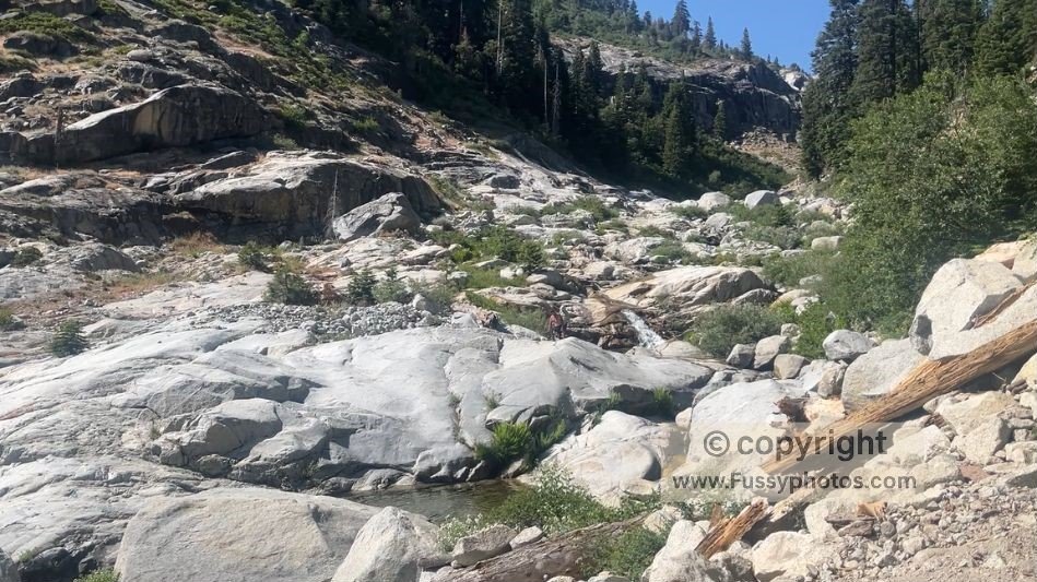
Sweeping views kept our spirits high, but we were still relieved when the path dropped into Buck Creek, an attractive valley with inviting pools for cooling off. We passed a small campsite but pressed on, knowing that fewer miles today would mean more miles—and over 4,000 feet of elevation gain—the next day.
Bear Encounter near Bearpaw Meadow
As we approached Bearpaw Meadow, my partner suddenly stopped me. I had been oblivious to the fact that a black bear was feeding on the trail around 30 meters ahead. We waited for it to move on, filming cautiously as we backed away (see YouTube clip).
At Bearpaw Meadow Ranger Station, we filled our bottles from a faucet before being swarmed by mosquitoes as we set up camp. It was an eventful end to our first day on the High Sierra Trail.
Watch Day 1: Into the High Sierra on Sequoia’s Best Backpacking Loop

FAQs — Backpack the High Sierra Trail Now: 5‑Day Loop
How long is the hike from Crescent Meadow to Bearpaw Meadow?
The distance is 11.4 miles (18.2 km) one way, with roughly 2,300 feet of elevation gain. Most backpackers complete it in a single day, though it’s a full, steady effort.
Can I start from Wolverton instead of Crescent Meadow?
Yes. Wolverton connects to the High Sierra Trail via a short link trail. It’s a good alternative when Crescent Meadow parking is restricted or when using the summer shuttle system.
What is the trail like in the first few miles?
The first half‑mile travels through shady, well‑watered forest with red and white fir, sugar pine, and occasional giant sequoias. After that, the trail opens onto a warm, south‑facing slope at Eagle View with big views toward Moro Rock and the Great Western Divide.
Are there water sources before Bearpaw Meadow?
Yes — typically spring‑fed streams, Mehrten Creek, and Buck Creek.
Is the trail exposed between Crescent Meadow and Bearpaw Meadow?
Several sections are narrow and exposed, especially along the steep bluffs near Alta Meadow and the traverse toward Buck Canyon. Most hikers manage these sections comfortably with care.
What are the best views before reaching Bearpaw Meadow?
Highlights include Eagle View, the traverse across the south slopes of Alta Peak, and the dramatic drop into Buck Canyon.
Can I start the High Sierra Trail from Lodgepole instead of Crescent Meadow?
Yes — you can start the Hamilton Basin Loop from Lodgepole, but it adds extra distance and elevation compared to starting at Crescent Meadow or Wolverton. From Lodgepole, hikers follow the Lodgepole–Sherman Tree Trail, then connect to the Lakes Trail (and Wolverton Creek). lodgepole offers secure parking and reliable bear lockers.
Where can I camp if I don’t want to go all the way to Bearpaw?
Many hikers choose to camp at Nine Mile Creek (8.8 miles in), where two forks offer water and established sites. It’s a popular option for those pacing themselves for a longer Whitney‑bound itinerary.
Is Bearpaw High Sierra Camp open to backpackers?
The historic Bearpaw High Sierra Camp (the tent‑cabin lodge) has been closed for several seasons and may remain closed.
How difficult is the final climb to Bearpaw Meadow?
After crossing Buck Creek, the trail climbs about 500 feet in just over a mile. It’s the steepest part of Day 1 and often feels challenging after a long approach.
Do I need a wilderness permit for this section?
Yes. Any overnight trip on the High Sierra Trail requires a Sequoia–Kings Canyon wilderness permit, and Crescent Meadow is one of the most competitive trailheads.
Is Crescent Meadow accessible by car?
In summer, Crescent Meadow is often shuttle‑only on weekends. Wilderness permit holders may access the trailhead 24 hours a day, even when the road is closed to general traffic.
Keep reading: Backpack the Hamilton Basin Loop: part 2
Discover More Sequoia National Park Adventures
For practical details on permits, start points, campsites, and route variations, the Hamilton Basin Loop trip‑planning guide breaks down everything you need to plan your own version of this 5‑day circuit.