
The Chiricahua Big Loop hike is the best way to experience the park’s surreal hoodoos, narrow canyons, and sweeping viewpoints in a single day. In the far southeastern corner of Arizona, Chiricahua National Monument rises from the desert in a maze of stone spires and balancing rocks — a landscape so strange and beautiful it’s known as the “Wonderland of Rocks.” This guide covers everything you need to explore the park, from scenic drives and camping to the full Big Loop route.
Where is Chiricahua National Monument?
Chiricahua National Monument sits in the Chiricahua Mountains, about 2 hours east of Tucson and 3.5 hours southeast of Phoenix. If you’re planning a wider journey through the desert parks, you can see my full Southwest NPS road trip guide for how Chiricahua fits naturally between Saguaro, Guadalupe Mountains and Carlsbad Caverns.
How do you get to Chiricahua National Monument from Wilcox?
The nearest town is Willcox, just 35 miles away, making it the best base for supplies, fuel, and accommodation. From Tucson, take I‑10 east to Willcox, then follow AZ‑186 and AZ‑181 into the park.
What Are the Top Things to Do in Chiricahua National Monument?
For the park’s most iconic adventure, the Chiricahua Big Loop hike combines hoodoos, canyons, and the famous Heart of Rocks in one full‑day route.
Best Hikes in Chiricahua National Monument :
- Echo Canyon Loop (3.3 miles) – The most popular trail, a circular hike weaving through narrow rock passages and towering hoodoos.
- Heart of Rocks Loop (7.3-9.5 miles) – A must‑do for its whimsical rock formations like “Duck on a Rock” and “Punch and Judy.” This strenuous trail is accessible only after a hike in via Lower Rhyolite Canyon (omitting the scenic drive), or taking one of three trails from Massai Point (with the option of a circular or an out-and-back to this point).
Bonita Canyon Scenic Drive
The 8‑mile Bonita Canyon Drive climbs from the visitor centre to Massai Point, offering sweeping views over the “Wonderland of Rocks.”
Wildlife & Birdwatching
Look for coatis, javelinas, and almost 200 bird species — including elegant trogons in summer. We loved sitting around the campground listening to the birds and they weren’t shy about getting close and letting us see them.
Faraway Ranch
Tour Faraway Ranch, a preserved homestead and guest ranch that tells the story of Swedish immigrants who helped promote the area’s beauty.
Stargazing in Chiricahua National Monument: Best Spots and Dark Sky Access
Chiricahua National Monument is an International Dark Sky Park. We didn’t stargaze. The campsite was sheltered, but the ranger did recommend heading back towards the entrance and Faraway Ranch or up the scenic Bonita Canyon Drive towards Echo Canyon in order to do so. Both would require getting in your car.
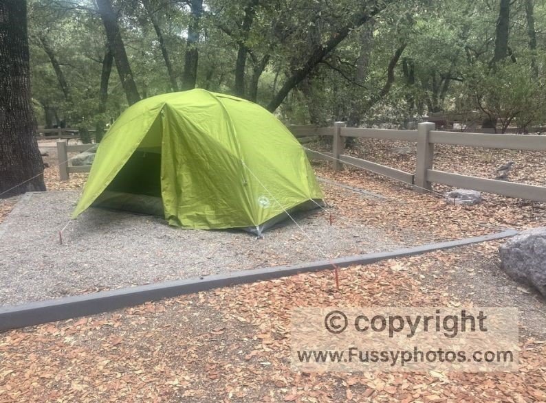
Bonita Canyon Campground in Chiricahua and Lodging in Nearby Willcox
- Bonita Canyon Campground: There are 25 sites, shaded by oak and pine, with restrooms and water but no showers. You can serve online at Recreation.gov. The road to the campground goes through a creek – it was dry there in when we visited in summer but it’s worth considering at other times of the year.
- Nearby Lodging: Willcox offers motels, B&Bs, and guest ranches. For a unique stay, look for cabins or casitas in the surrounding countryside.
What Are The Best Times to Visit Chiricahua National Monument
- Spring (March–May): Wildflowers bloom, temperatures are mild, and wildlife is active.
- Summer (June–August): This is when we visited. Expect hot days and afternoon monsoon storms — it’s still a great destination if you start and finish your hiking early. We found temperatures in the shaded Bonita Canyon Campground very comfortable when we arrived in the day.
- Autumn (September–November): Cooler weather, fewer crowds, and golden foliage in the canyons.
- Winter (December–February): Quiet trails and occasional snow dusting the rock pinnacles.
Exploring Chiricahua’s Canyons, Wildlife, and Nearby Attractions
The labyrinthine canyons reminded me a little of Canyonlands and are great fun for exploring, with or without kids. You don’t have to be a bird lover to appreciate the songs and sounds of the almost 200 species documented in the park. It’s a bit isolated if you’re doing a road trip but with a bit of research you can tie it in with other attractions.
Hiking the Chiricahua Big Loop Trail
Early Start at Massai Point
After a night at the enchanting Bonita Canyon Campground, we set off early for Massai Point via the scenic Bonita Canyon Drive. As always when hiking in the desert, our goal was to be off the trail before midday.
Finalising the Route
I’d studied maps and photos intensively before visiting and considered starting from the Visitor Center via the Lower Rhyolite Canyon Trail, connecting east to the Sarah Deming Trail and the Heart of Rocks Loop — the park’s showcase trail. Instead, slightly deterred by some questionable reviews and a ranger’s advice the day beforehand, we opted for “The Big Loop,” a circular route that highlights a unique blend of canyons and balancing rocks including the Heart of Rocks Loop and sections of Sarah Deming Trail.
Chiricahua NM & Big Loop Annotated Trail Map and Elevation Profile
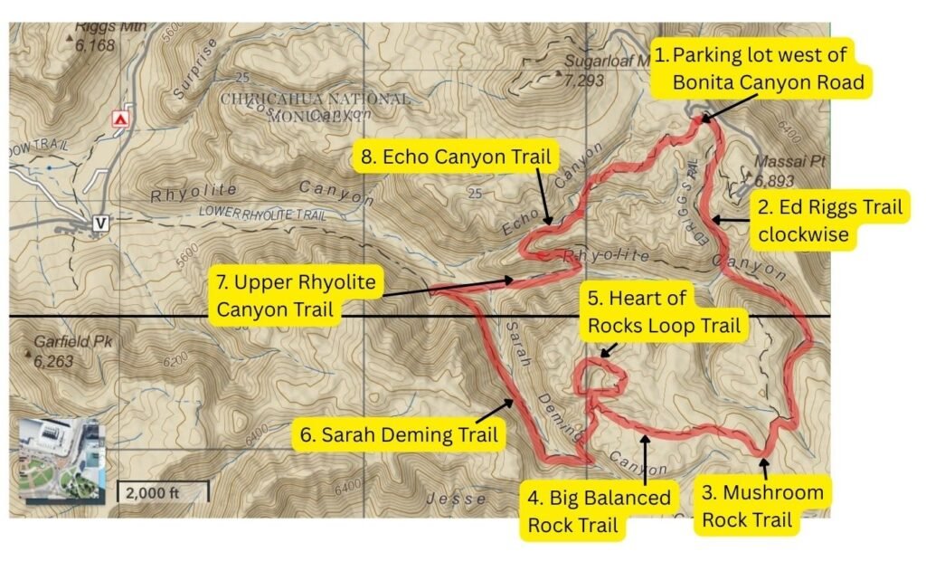
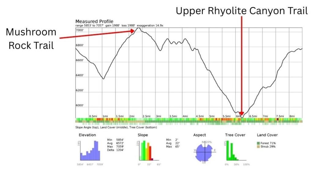
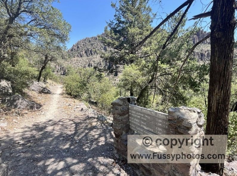
Ed Riggs Trail to Mushroom Rock Trail
The Ed Riggs Trail greeted us with birdsong, shade, and a gentle climb. Mushroom Rock Trail, arguably the least scenic of the day, led us to a high plateau with distant views of the formation.
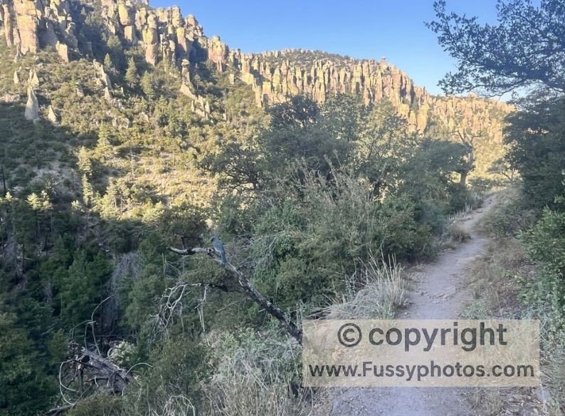
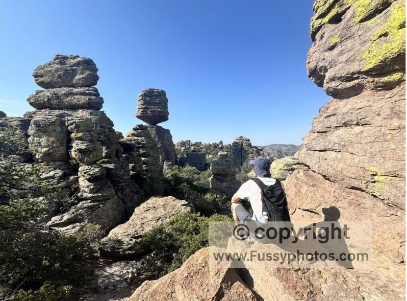
Balanced Rock & Heart of Rocks Loop
We had fun posing for photos and relaxing at Balanced Rock — a precarious boulder impossibly balanced on its tip.
The Heart of Rocks Loop took us down, then up through spires and formations, with ever-changing views and features like “The Camel.” It’s a fun section of the park for adults and children! See my YouTube clip for more.

Sarah Deming Trail: A Surprise Favourite
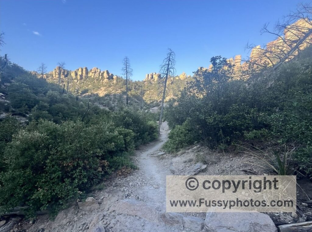
Though technically a connector, the Sarah Deming Trail was my favourite of the day. It led us through a wide canyon toward Rhyolite Canyon, with hoodoos reminiscent of Bryce Canyon National Park in Utah. At this point, I wished we’d taken the Lower Rhyolite Canyon Trail — its continuation of hoodoos and winding paths tempting us to continue.
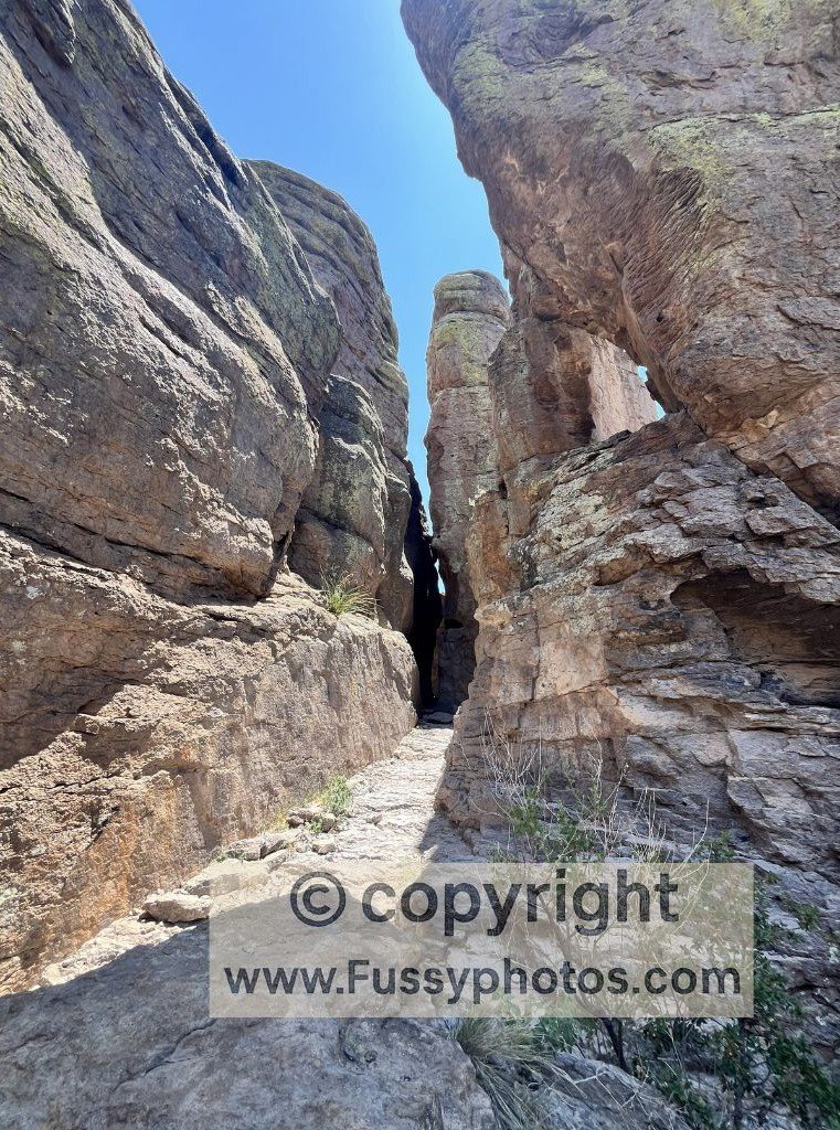
Echo Canyon Finale
We looped east, descending and climbing out of Echo Canyon under the blazing sun. The Echo Canyon Trail offered magical formations, a labyrinth of narrow passages, and precious shade.
Tired and hot, the final mile stretched on — but soon the trail levelled out, and we escaped the heat with the air conditioning cranked high!
FAQs About Hiking the Big Loop in Chiricahua NM
Is the Big Loop Trail difficult?
Yes. The Big Loop is considered strenuous in places, especially if hiked clockwise. Expect elevation gains along Mushroom Trail and steep ascents in Upper Rhyolite Canyon and Echo Canyon Trail.
What makes the Big Loop challenging?
Beyond the climbs, the heat is the biggest factor. Large sections of the trail are exposed to full sun, so carrying plenty of water, pacing yourself, and starting early are essential.
Does the Big Loop include Heart of Rocks Trail?
The Big Loop encompasses a remarkable mix of canyons and balancing rock formations, weaving in both the Heart of Rocks Loop and portions of the Sarah Deming Trail. While the Heart of Rocks Loop can be bypassed if you’re pressed for time or prefer a shorter hike, it is widely regarded as the highlight of Chiricahua National Monument, showcasing the park’s most iconic and unforgettable formations.
Watch: Chiricahua NM & Big Loop Trail Highlights

How Chiricahua National Monument Fits into a Southwest Road Trip
Chiricahua National Monument, with its surreal rock formations and quiet trails, is well-positioned for a variety of regional adventures across Arizona, New Mexico, and West Texas:
- For a full breakdown of how these parks link together, my Saguaro → Chiricahua → Guadalupe Mountains → Carlsbad itinerary covers the exact route and what we’d do differently next time.
- Tucson is approximately 2 hours northwest, making it the nearest major city and a natural base for exploring Southern Arizona.
- Saguaro National Park, known for its towering cacti and desert vistas, is also around 2 hours northwest.
- Phoenix lies about 3.5 hours northwest, offering a broader range of amenities and travel connections.
- El Paso is roughly 4 hours east, serving as a gateway to West Texas and the Chihuahuan Desert.
- Guadalupe Mountains National Park is approximately 5.5 hours east, ideal for those continuing into Texas for high-elevation hikes.
- Carlsbad Caverns National Park is around 6 hours east, making it a longer but rewarding extension for cave exploration and desert scenery.
Whether you’re linking desert parks or crafting a multi-state itinerary, Chiricahua slots beautifully into a Southwest road trip with dramatic landscapes and fewer crowds.
If you enjoy full‑day desert routes like the Chiricahua Big Loop, you might also like my Wasson Peak & Kings Canyon trail guide in Saguaro National Park — a rewarding climb through classic Sonoran Desert scenery. For a canyon‑and‑cliff masterpiece, my Half‑Day Death Valley Itinerary includes the Golden Canyon–Gower Gulch Loop, one of the park’s most colourful and dramatic hikes. I’m also working on new guides to Canyonlands National Park and Goblin Valley State Park — two spectacular Utah landscapes filled with canyons, hoodoos, and wide‑open desert terrain.
Discover More American West Adventures
A curated hub of my best routes across the American West — from desert classics and canyon adventures to volcanic landscapes and high‑mountain epics.
A rewarding climb through classic Sonoran Desert scenery, with sweeping views and a peaceful early‑morning atmosphere.
A sunrise‑friendly route through Golden Canyon, Red Cathedral, Badlands Loop, and Gower Gulch — a colourful, dramatic introduction to Death Valley’s canyon and volcanic terrain.