Death Valley: Tips and Lessons Learned
Roadtrippers traveling east–west (or vice versa) between Utah, Las Vegas, and the Sierras/coastal California inevitably spend hours crossing desert. It’s a stark contrast to the giant trees and golden beaches of California, the red‑rock canyons of Utah, and the bright lights of Las Vegas. Crossing Death Valley National Park can be both a necessity and an opportunity, and these Death Valley tips are shaped by that reality. Beautiful but brutally hot, the park is far more popular in winter than summer for obvious reasons — yet it’s still possible to visit and enjoy year‑round with the right caution.
How Death Valley Fits Into a Road Trip
- Las Vegas — 2 hours east of Furnace Creek. Famous for its neon skyline, endless entertainment, and easy airport access, Las Vegas is the most common gateway to Death Valley and a natural start or end point for a Southwest road trip.
- Sequoia National Park – 6.5 hours west of Furnace Creek. Explore the towering sequoia groves and classic high‑country trails, including Moro Rock, the Giant Forest, and the High Sierra Trail. A perfect cool‑weather contrast to Death Valley’s desert heat.
- The Eastern Sierra — around 2.5 hours northwest. Trails like Kearsarge Pass Trail offer fast access into the high alpine wilderness and serve as a gateway to Kings Canyon National Park. Ideal if you’re pairing desert landscapes with big‑mountain scenery.
- Yosemite via Tioga Pass — 4 hours northwest. When Tioga Road is open, this is one of the most spectacular transitions in the American West. Highlights include Tenaya Lake, the Four Mile Trail, the Panorama Trail, the Mist Trail Loop, May Lake, Lembert Dome and of course, Half-Dome
- Zion National Park — 4.5 hours east. A natural stop on a Utah–Nevada loop, with iconic routes such as the Zion Traverse, Angel’s Landing, Observation Point, The Narrows and the quieter Kolob Canyons area.
- Grand Canyon — 6.5 hours east to the South Rim. A classic extension to any Southwest itinerary, with world‑class corridor trails like the Bright Angel Trail and the South Kaibab Trail.
- Saguaro National Park — 8.5 hours southeast. If you’re chasing warmer weather or planning a winter road trip, Saguaro’s desert trails and giant cacti offer a completely different feel — ideal for mild‑temperature hiking in winter.
Camping in Death Valley in Extreme Summer Heat
Why Camping Near Furnace Creek Is a Bad Idea in Summer
Extensive research before our trip made one thing very clear: camping in the lower‑altitude areas of Death Valley, anywhere near Furnace Creek, is essentially self‑torture in summer. The heat doesn’t ease, even at night, and it’s frankly unwise unless you enjoy slow roasting yourself in a tent.
Why Hotels Weren’t an Option
The obvious alternative was hotel accommodation, but options inside Death Valley are limited and, especially in summer, extremely expensive. Traveling on a budget, this was an option we wanted to avoid.
The further you get from the park, the cheaper accommodation becomes — but the need for it also drops. Death Valley is surrounded by vast stretches of empty desert, so hotels only exist around tourist hubs. Beyond that, there’s simply nothing.
The Problem With Staying Too Far Away
This becomes even more important in summer. Staying an hour outside the largest national park in the lower 48 means a lot of pre‑dawn driving if you want to start hiking early enough to avoid dangerous heat. I’ve learned this lesson on other desert hikes too, especially the South Kaibab–Bright Angel river‑to‑river loop, where pre‑dawn starts are the only safe way to beat the heat.
It’s a classic catch‑22:
- Sleep comfortably far outside the park, and you’ll face a long morning drive and miss the best hiking conditions.
- Camp too close, and you’ll be too hot to sleep at all.
Considering First‑Come, First‑Served Campgrounds
There are first‑come, first‑served campgrounds inside the park, like Emigrant Campground. At around 2,100 feet, it’s slightly cooler than Furnace Creek. But after a full day hiking in the Sierras, I worried we’d arrive too late and find it full — leaving us with a real problem and nowhere to stay.
Why We Chose Panamint Springs
In the end, Panamint Springs felt like the best compromise. It’s just inside the park boundary, sits at roughly 2,000 feet (cooler than Furnace Creek), and is far enough west that we could enjoy a day in the mountains and still arrive in time for last light.
Sleeping Conditions in Summer and Light Pollution at Panamint Springs
We arrived in a rush at around 20:50, the light having faded to nothing, and found the office closing at 21:00. Thankfully, the staff were really helpful. We searched for our pitch in the dark, illuminated only by the bright but slightly distant glow of the restaurant and shop signs.
With the car headlights on, we pitched our tent in 105°F heat, telling ourselves it would cool down later. It didn’t.
Tired, and with the tent feeling like a furnace, we ended up lying on a picnic bench and stargazing. The night sky was surprisingly clear despite the heavy light pollution from the buildings. Panamint Springs has more artificial light than you might expect for such a remote spot. The small resort, gas station, and campground lights create a noticeable halo, especially if you’re used to true dark‑sky locations. It doesn’t ruin the stargazing — the sky is still spectacular — but it does take the edge off that deep‑desert darkness you might be imagining.
With no breeze at all, the tent trapped heat and felt unbearable. We walked to the showers by torchlight, hoping a cold rinse would take the heat off. Naive thinking — the water was piping hot, too hot to stand under, the tank no doubt superheated by the afternoon sun.
The combination of lingering summer heat and scattered artificial light made the night far less restful than we hoped, and it definitely shaped how we were felt the next morning.
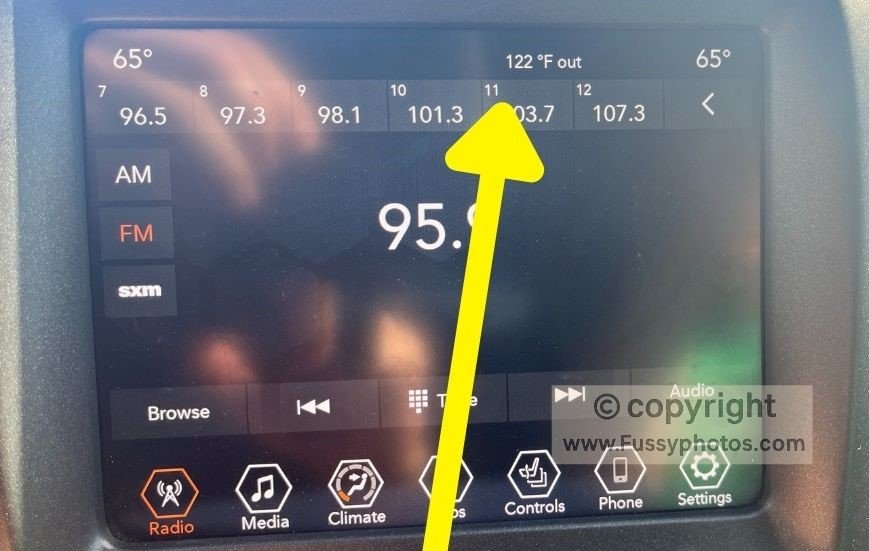
How a Long Drive Affects Early Starts in Summer
Though we woke early, the temperature was 91°F and following the one‑hour drive to our trailhead meant the temperature was higher when we started our hike at 06:50.
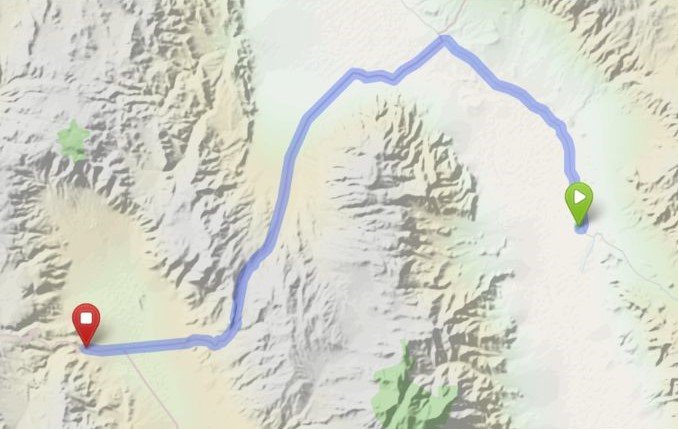
Map key:
🟥 Red marker — Panamint Springs Resort
🟩 Green marker — Furnace Creek Visitor Center
📏 Distance between markers: approx. 56 miles (1 hour’s drive)
Watch: Why Timing Matters in Death Valley

Where to Stay in Death Valley (and Why Furnace Creek Is Worth It)
Why Furnace Creek Is Worth Paying For
- You’ll sleep far better — and dramatically reduce the chances of falling out with your partner or family.
- You’ll have an air‑conditioned room, which is essential in summer. Despite what school lessons say about deserts cooling down at night, Death Valley absolutely does not.
- With proper rest, you can wake up early and enjoy a much shorter drive to the trailhead, giving you a real chance at an early‑morning hike before the heat becomes dangerous.
- Starting earlier also means you’ll have time to return to your room, shower, and cool down before checking out — a luxury you’ll appreciate more than you expect after a summer hike in Death Valley.
With the benefit of hindsight, here’s the modified 1/2 Day Death Valley Itinerary we should have followed.
Hiking Safety, Heat & Hydration
For essential advice on avoiding heat illness, managing hydration, and staying safe on strenuous desert trails, explore the full Hiking Safety, Heat & Hydration category.
Southwest Desert Hiking
Explore more canyon, desert, and red‑rock routes across Utah, Nevada, Tucson, and the wider American Southwest — ideal if you’re pairing Death Valley with Zion, the Grand Canyon, Tucson’s desert trails, or the Eastern Sierra.