Capitol Reef Backcountry Loop Overview (2‑Day Route)
I wanted to see as much of the park as possible while sticking to established trails. If you’re still getting a feel for the park as a whole, my guide on why Capitol Reef is such an underrated national park gives a helpful overview before diving into a backcountry route. Most of Capitol Reef’s standout hikes are short day walks or point‑to‑point canyon routes, but I was after something different — a Capitol Reef Backcountry Loop experience with solitude, tranquillity, and minimal retracing of steps.
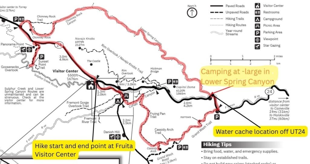
With three days to explore the park, I designed my own 2‑day loop using established trails, a strategic water cache, and a manageable 22‑mile route that linked Fruita, Chimney Rock, Lower Spring Canyon, Grand Wash, Cassidy Arch, Frying Pan, and Cohab Canyon into one continuous backcountry adventure.
Permits for the Capitol Reef Backcountry Loop
Permits are free, easy to obtain from the Visitor Center, and no advance booking required — unsurprisingly in July, when few choose to camp out in the backcountry.
Capitol Reef Summer Hiking: Heat Safety & Water Caching
- Avoid hiking between 10 a.m. and 4 p.m.
- Seek shade and carry plenty of water.
- Use the UT-24 road to cache water rather than carry two full days’ supply plus camping gear.
Capitol Reef 2‑Day Backcountry Hiking Loop — Fruita’s Best Trails
Capitol Reef National Park offers a wealth of hiking opportunities, from scenic day hikes to remote backcountry routes. Most day hikes are out-and-backs, while the narrow canyons—ideal for solitude—tend to be point-to-point. With three days to explore the park, I wanted to cover as much ground as possible without retracing my steps. That meant designing my own loop hike using established trails, a strategic water cache, and a manageable 22-mile route.
How to Plan a Capitol Reef Backcountry Loop Hike
To make the loop work, I cached water along Highway 24 and the Fremont River. This allowed me to pick up water mid-hike without detouring or carrying excessive weight. The loop had its drawbacks—Lower Spring Canyon is a point-to-point trail, so I’d need to hike a stretch of road. Early morning was the best time for this, with cooler temperatures and lighter traffic.
Hike planned and no concerned eyebrow raises from the ranger at the permit office the following day, I spent the night before caching water and hiking Hickman Bridge. In the desert and semi-desert, I always try to remember the mantra of avoiding hiking between 10 a.m. and 4 p.m.
If you’re not ready for a full backcountry loop, my Capitol Reef One Day Itinerary covers the best short hikes and heat‑safe planning tips.
Capitol Reef Backcountry Loop — Day 1: Fruita to Lower Spring Canyon
- Start: Fruita Visitor Center
- End: East end of Lower Spring Canyon
- Day 1 begins at the Fruita Visitor Center, detours to Gooseneck Overlook and Chimney Rock Trail, and finishes at the east end of Lower Spring Canyon.
Capitol Reef Backcountry Loop — Full Route Map
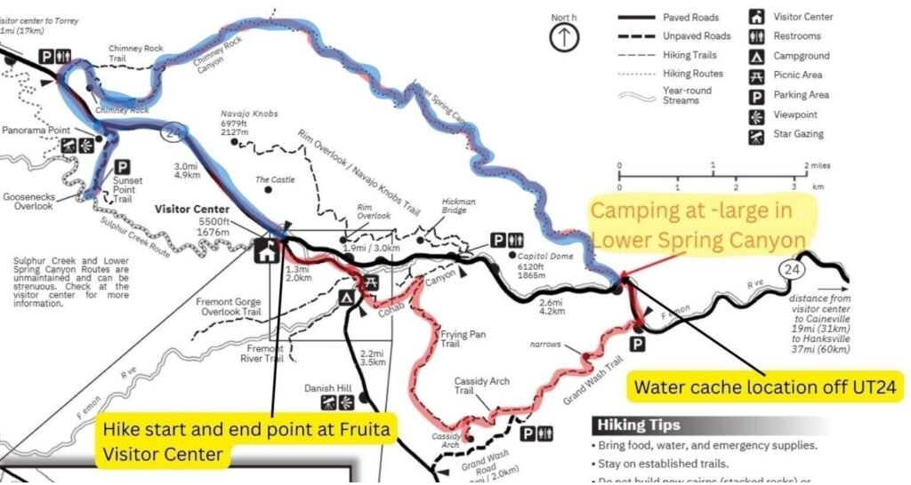
Day 1: Fruita – Lower Spring Canyon (via Gooseneck Overview and Chimney Rock Trail) Route Profile Summary
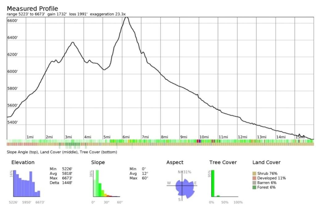
Day 1 Elevation Profile — Key Stats
- Elevation range: ~5223 ft (low) to ~6673 ft (high)
- Distance: 15 miles
- Elevation gain: 1732 ft
- Elevation loss: ~1991 ft
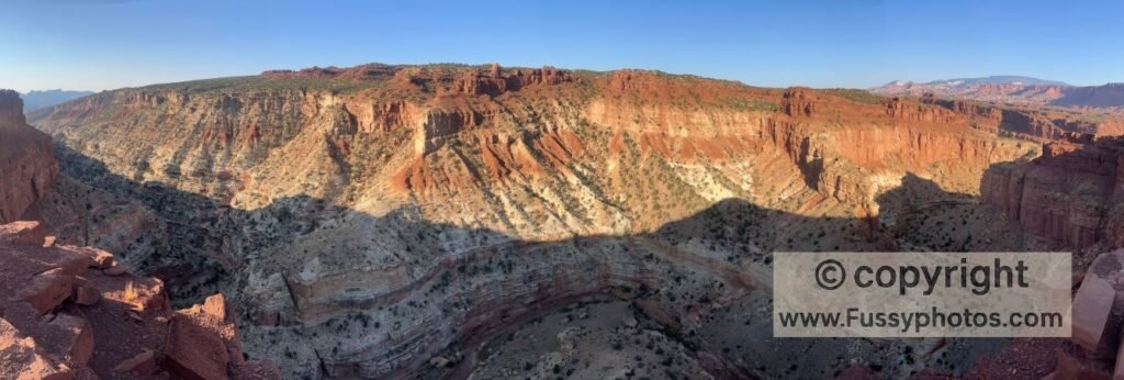
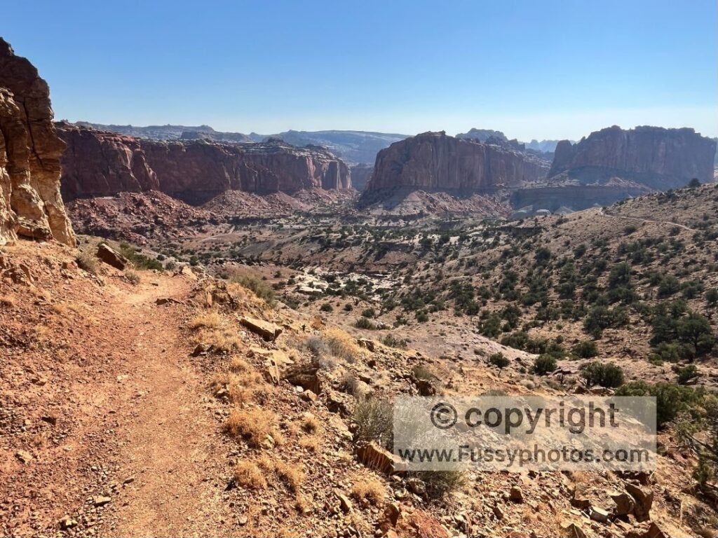
Day 1 begins with an hour’s road walking, following Route 24 uphill and then a flat detour to Gooseneck’s Overview. Returning to the road, the elevation drops before rising sharply in on the exposed Chimney Rock Trail giving elevated views to the south. The trail then descends towards Lower Spring Canyon where the next 9 miles continue downhill.
Water Caching for the Capitol Reef Backcountry Loop
- Cache water at the east end of Lower Spring Canyon (for Day 2).
- Cache water at Chimney Rock Trailhead (west entrance to the canyon).
- Park at Fruita Visitor Center and walk 2.5 miles up the road to Chimney Rock to first water cache.
Hiking Utah 24 to Goosenecks Point (Capitol Reef Backcountry Loop)
So at dawn, I was off—and with so much water despite my cache plan, hiking up Utah 24 was slow going. Nearing the end of my road walking, I had the idea to add Goosenecks Point to the trip. Although not part of my rigorous plans, the mood took me to add two miles of hiking to include the viewpoint. When I detoured west and immediately picked up my first phone signal in over a day, the opportunity to call home while adding some easy miles seemed too good to miss.
An hour and a half into my hike, I still arrived sufficiently early to have the place to myself and to capture the sun’s rays illuminating the deep canyon below. In fact, I was feeling so good that when a car stopped and offered me a lift to my next trail (Chimney Rock), I politely declined.
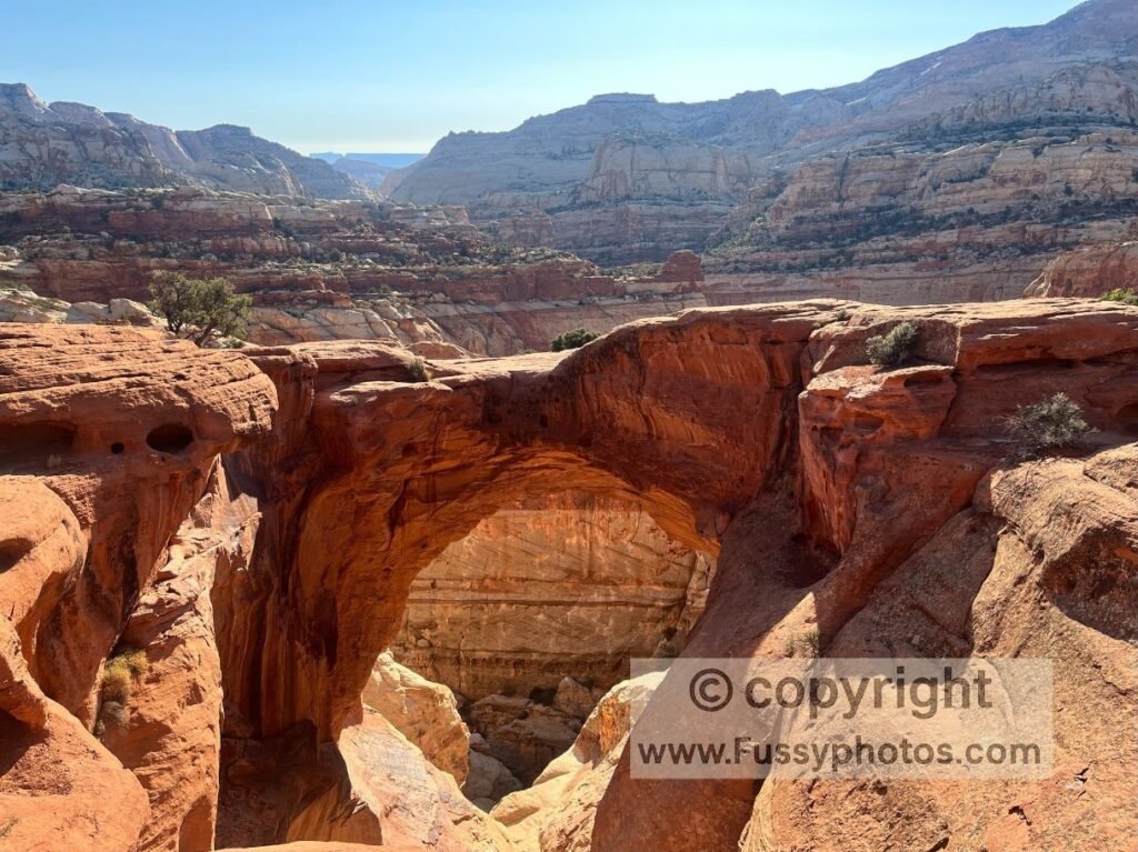
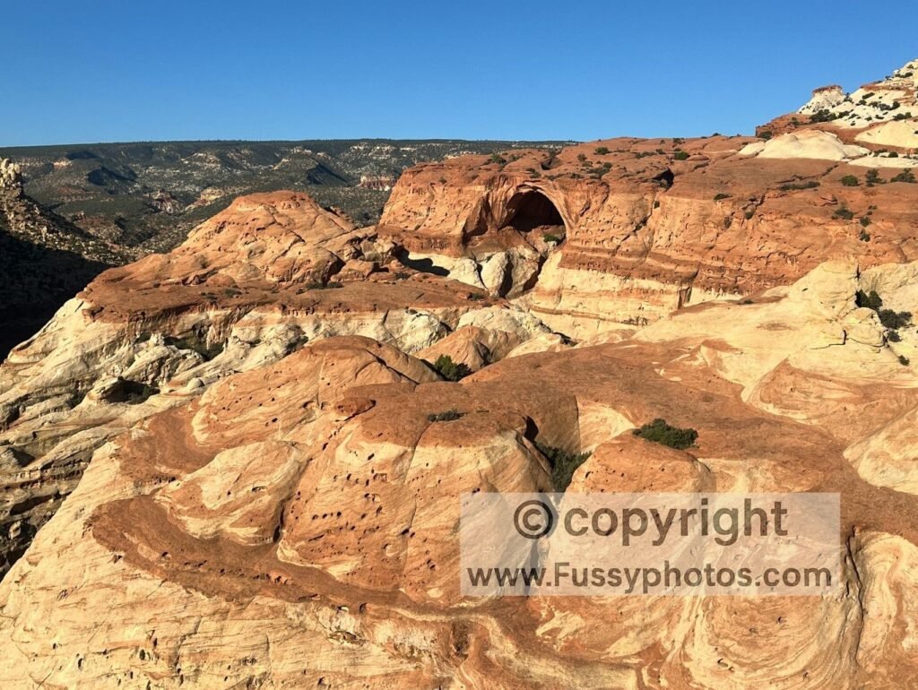
Chimney Rock Trail on the Capitol Reef Backcountry Loop
Reaching Chimney Rock Trailhead 2.5 hours after my hike began, I was surprised to see no cars at the trailhead. I collected my first water cache, adding yet more weight to a bulging backpack, and continued forward—choosing to take the Chimney Rock Trail anticlockwise to enjoy the bigger views offered versus the shorter route clockwise to Lower Spring Canyon.
The trail involved some initial sharp inclines, but the payoff was big: wide vistas of the Waterpocket Fold (a 100-mile-long fold in the rock along the park’s north–south axis), elevated views of Goosenecks Point, and red rock as far as the eye could see. The trail itself was a lot of fun too—I love the appearance of a trail looping around the contours, teasing you with a spoiler of what’s to come.
All in all, I was mightily impressed with the Chimney Rock Trail, and having taken so many photos and video, I wasn’t even in Lower Spring Canyon by my self-imposed cut-off time of 10 a.m. For a shorter, day‑hike version of this route, see my Capitol Reef One Day Itinerary.
Hiking Lower Spring Canyon Trail: Heat strategy and a Fox Encounter
With hindsight, perhaps I should have stayed where I was. With a gentle breeze and open views, I was comfortable—though probably an hour at least behind schedule already. Excited and feeling strong, I was ill-disciplined and continued into Lower Spring Canyon.
Immediately, the trail felt different. Not just the views, which were—as expected—less open, but the kind of high-walled canyons that Zion is famous for. Also, the temperature: it was noticeably hotter and stifling. Having twice hiked the South Kaibab–Bright Angel river‑to‑river loop in summer, I recognised the same canyon‑heat pattern here — the walls trapping warmth and the temperature rising faster than expected. Again, with hindsight, it wasn’t too late to turn back to the spot of my last drinks break, though it would have been frustrating.
Instead, I excitedly continued into the canyon, optimistic about finding shade and a spot not yet warmed by the morning heat. After maybe half a mile, I came to an interesting spot, with a large rock creating an overhang and rock below forming a natural seat. The overhang was sufficiently big for me to move around as the sun crossed the sky over the next few hours.
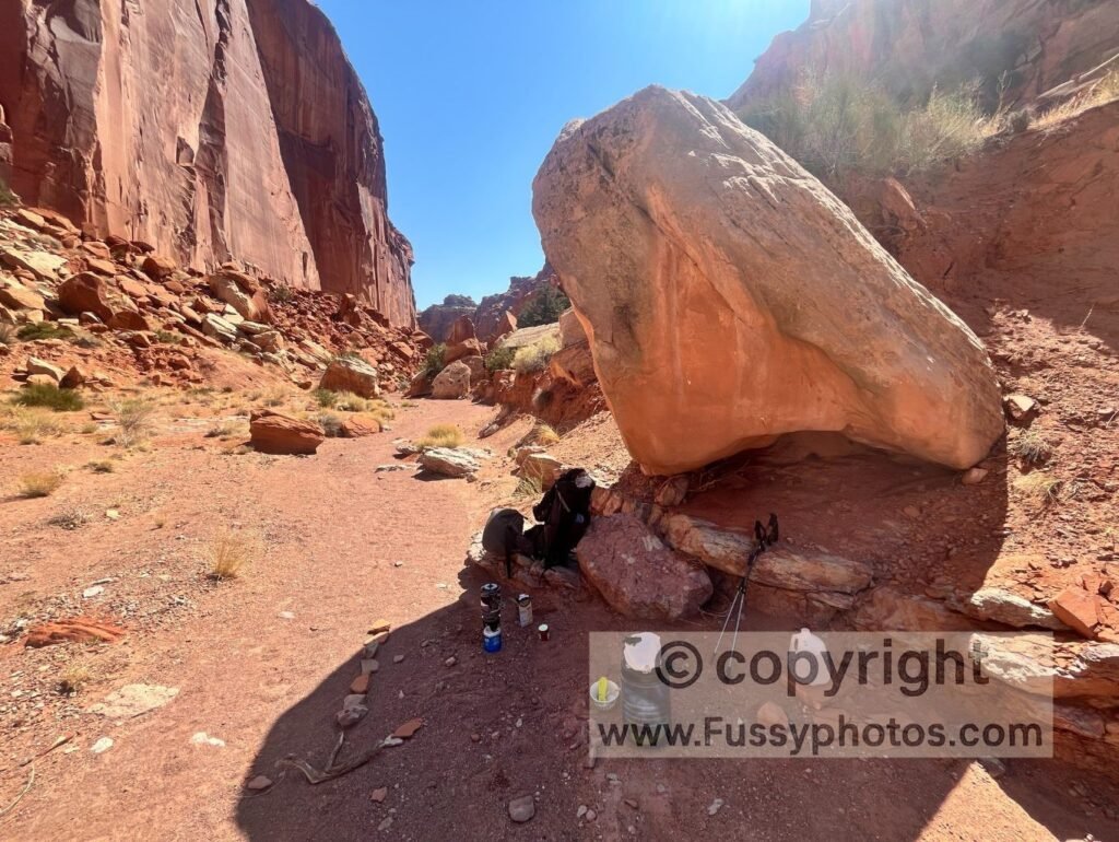
Hot but content, I emptied my cooking gear from my backpack and started to cook some pasta. My guard down, I was looking down the canyon when a Gray Fox came trotting through the wash—no doubt using the trail as the path of least resistance. We both startled each other, then a 10-minute staredown began.
Ordinarily, I would have gotten out of the way, but my water was boiling beyond the point of return. So I stood my ground, and the fox stood his. Minutes passed, then he snuck into the shadows beyond some large boulders and out of sight. A little flustered, I somehow knocked my cooking pot over, losing around a liter of precious water in the process. That would have implications later…
Midday Heat in Lower Spring Canyon (Capitol Reef Backcountry Loop)
Following lunch, I pulled out a book I was carrying—extra weight, but brought exactly for these hours when it was too hot to hike. The temperature kept rising and I wasn’t comfortable. The combination of the stifling canyon and now feeling open and vulnerable following the animal encounter, I shifted around but after two hours decided to pack up and look for a better spot.
A gentle 10 minutes along the trail confirmed that it was too hot to hike, and so I was pleased when I found a second spot with a much bigger overhang—resembling more like a cave, actually. It was a formation of rocks from a rockfall. Although well shaded, this spot was just as hot, and despite trying to take my mind off the heat with my book, it felt like being in a slow-cook oven.
Some sugary snacks helped, though not entirely. My GPS said the other end of Lower Spring Canyon was some nine miles away, and the distance back to my car via the road and Chimney Rock Trailhead was five. The thought occurred that I could head back to my car, cool off, and restart the hike at the opposite end of Lower Spring Canyon that evening—but it was never more than a backup plan, one I didn’t want to act upon.
Afternoon Push: Scrambling Through Lower Spring Canyon
Three p.m. came, and having sat out for over four hours, it seemed now or never. Although hiking is ill-advised before 4 p.m. in summer, hiking relifted my spirits. Once I turned a corner in the sinuous canyon, the temperature dropped and I wondered why I hadn’t moved on sooner.
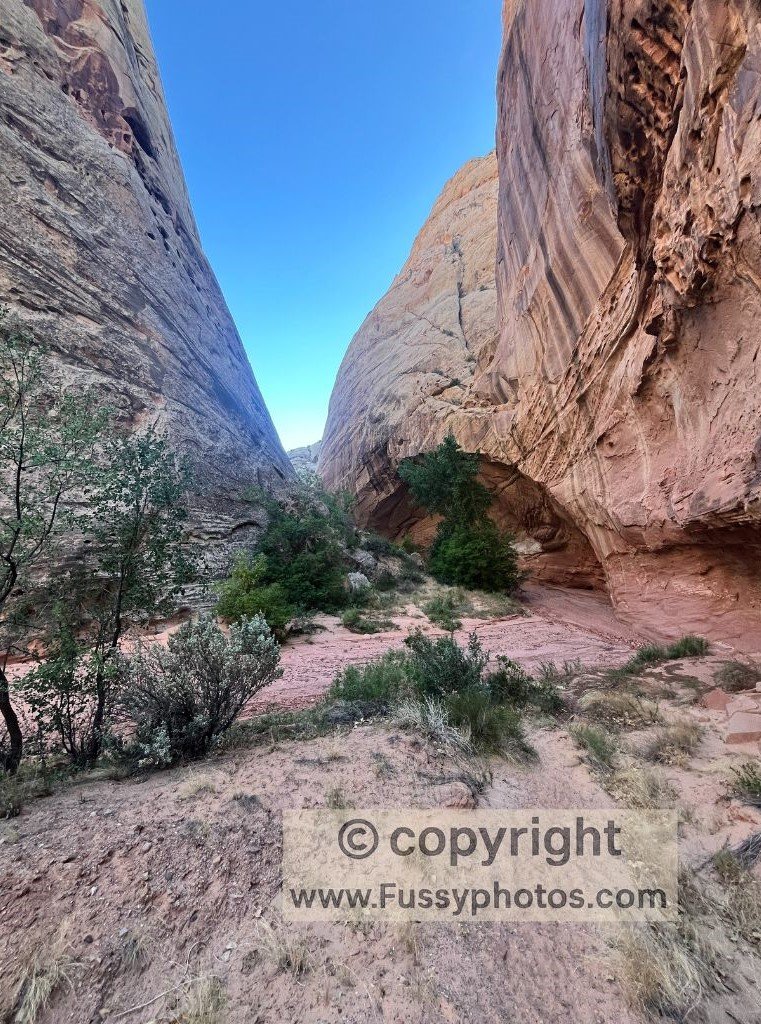
Lower Spring Canyon is spectacular. Narrow, with high cliffs either side, there is one way in and one way out (unless you take the 2–3 day route via Upper Spring Canyon). It was no surprise, therefore, that I saw no one else.

Navigation was largely easy—follow the high walls from west to east—but progress was anything but. Following a dried-up riverbed, the trail is littered with rocks, small and big. The canyon is clearly susceptible to rockfall too, with huge rocks at times requiring scrambling and some guesswork as to the best route forward.
For these reasons, progress was slow despite the lack of elevation gain, and I tried to put my foot down—but the result was a lot of fast-paced back-and-forth weaving up, around, and back around boulders.
Slot Canyon and Fremont River Finish (Capitol Reef Backcountry Loop)
Around halfway through the canyon, a gash appears below—a slot canyon within the canyon, almost. Here, the trail sticks left, but you’re traversing an incline and the footing is unstable. Exciting and spectacular, the implications of a fall would be bad, but unlikely life-threatening. More likely a twisted ankle or knee—and it’d be a tricky hike to either end of the canyon on one leg from here.
By 7 p.m., the terrain became more friendly to hikers looking to pitch a tent and camp at large. Yet, despite starting the day with a couple of gallons, I was getting low on water. The earlier spill at lunchtime—losing nearly a liter—was now catching up with me, and the need to reach my next cache had shifted from convenience to necessity. It was clear that I could get to the river before sunset—and that was an attractive option. I’d escape the exhilarating but by now claustrophobic feeling of being within the narrow canyon, I’d reach my water cache, and I could cool off in the Fremont River.
I managed all that, and the only thing remaining was to backtrack into the canyon and find the nearest suitable camping spot beyond the thick vegetation surrounding the river.
Watch: Capitol Reef Backpacking Loop Part 1 — Fruita, Chimney Rock Trail and Lower Spring Canyon

Capitol Reef Backcountry Loop: Hiking Map
Read Capitol Reef Backpacking Loop Part 2: Grand Wash to Cohab Canyon