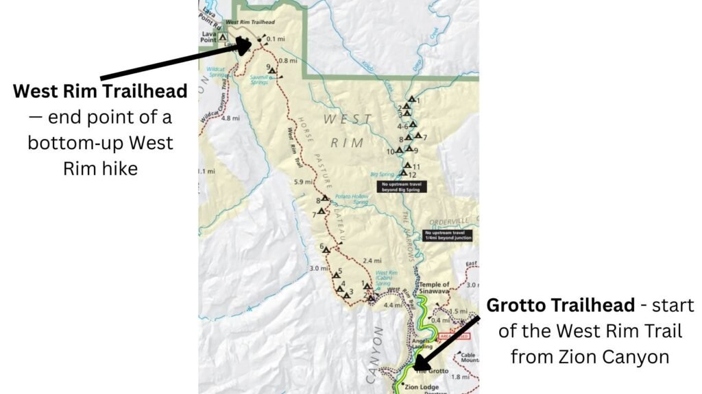
The West Rim Trail is one of Zion’s iconic routes, linking Lava Point in the center of the park with the Grotto Picnic Area below Angel’s Landing. It’s accessible either by private vehicle from Lava Point — reached via Kolob Terrace Road, almost an hour’s drive north of Springdale — or by shuttle from Zion Canyon. For a broader overview of the park’s layout, access points, and seasonal considerations, see my Zion National Park Guide.
It’s one of Zion’s longest day hikes or a rewarding short backpacking trip, using one or more of the nine designated campsites along the trail. The full point‑to‑point distance is 14.5 miles, though you can shorten it by about a mile by leaving the trail near Campsite 1 and taking the Telephone Canyon Trail, which rejoins the West Rim Trail north of Campsite 6.
The West Rim Trail is also encompassed within the Zion Traverse, a longer west‑to‑east crossing of the park. If you’re interested in the full 37‑mile Traverse, my Zion Traverse Guide covers the entire point‑to‑point route.
Route Option 1: Lava Point → The Grotto (Top‑Down)
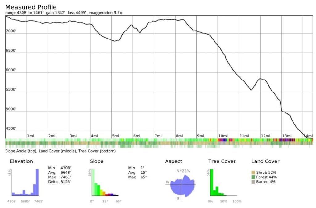
Route Profile Summary Top-Down
- Distance: 14 miles
- Elevation gain: 1,342 ft
- Elevation loss: 4,495 ft
- High point: ~7,461 ft
- Low point: ~4,308 ft
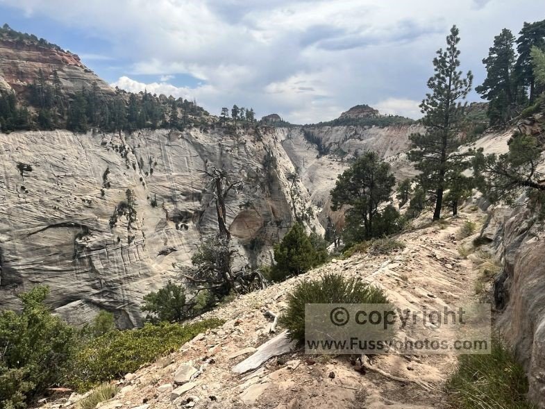
The route climbs steadily to a single high point around 7,450 feet before dropping into a long, sustained descent that defines the second half of the day. Slopes average a manageable 15°, with a short, steeper climb just after Potato Hollow (and campsite 6) and again a mile later ascnding to campsite 7. Overall, it’s a moderately strenuous route with a predictable rhythm: a steady climb, a scenic crest, and a long downhill finish.
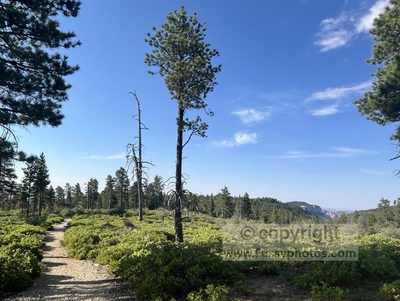
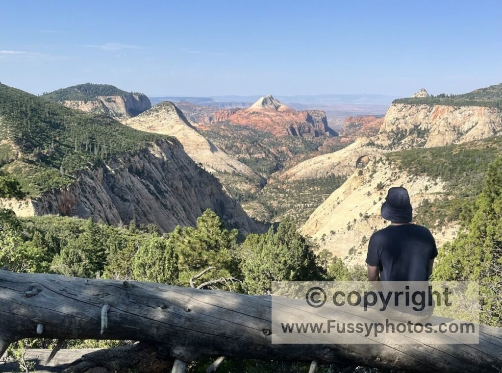
A Cooler, High‑Country Start
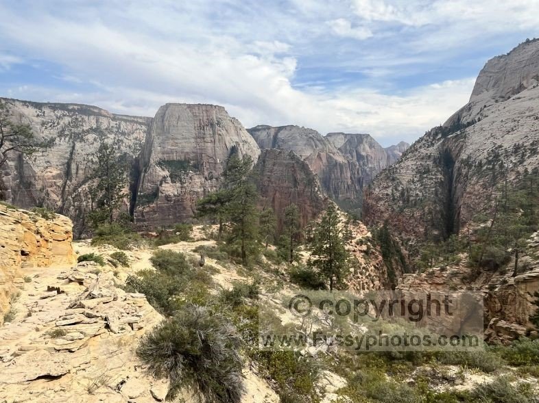
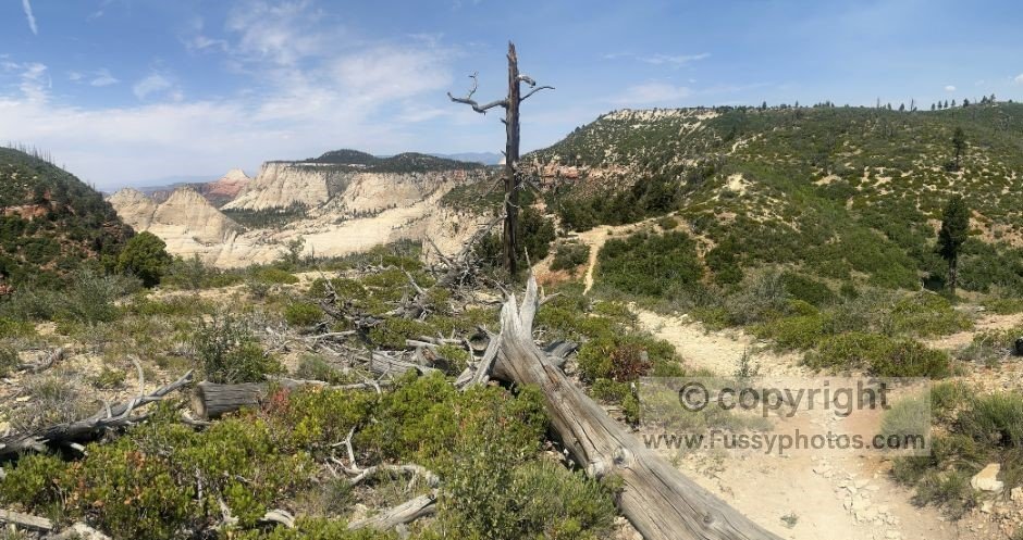
The West Rim Trailhead (north) begins at 7,450 feet, more than 3,000 feet higher than the Grotto. It’s noticeably cooler, especially in summer, and the first miles feel calm and spacious — high‑country meadows, forest, and long‑range views that build slowly toward the canyon drama ahead.
Although this direction is “mostly downhill,” you’ll still gain nearly 1,500 feet over the full hike. The ascent after Potato Hollow Spring is steep and sweaty, but overall the top‑down direction is ideal for anyone wanting to avoid major elevation gain — a huge advantage in the hotter months.
Why It’s Great for First‑Time Backpackers
The top‑down route is excellent for newer backpackers, especially in spring and fall when the springs are more reliable and the logistics are simpler. This section mirrors the final miles of my Zion Traverse Itinerary, so the photos and descriptions there give a good sense of what to expect.
Campsite Considerations
There are nine campsites along the West Rim Trail, each with its own pros and cons:
- Campsite 9 — closest to Lava Point; great for late starts
- Campsite 5 — excellent canyon views
- Campsites 1–3 — closest to Scout Lookout and Angel’s Landing, ideal for an early start on Day 2
If you plan to camp, my Zion NP Permit Guide explains how to book West Rim sites on Recreation.gov..
For official photos of all nine West Rim campsites, see the National Park Service’s West Rim Trail page.
Top‑Down Logistics (Shuttle Required)
The biggest logistical challenge of a top‑down hike is simply getting to the trailhead.
Two‑car method:
- Drive both cars to Springdale
- Leave Car A there
- Drive Car B to the West Rim Trailhead at Lava Point
- Hike to the Grotto
- Use Car A to return to Lava Point and retrieve Car B
Private shuttle:
The easier (but more expensive) option is to leave one car at the Zion Canyon Visitor Center and take a pre‑booked private shuttle to Lava Point.
Route Option 2: The Grotto → Lava Point (Bottom‑Up)
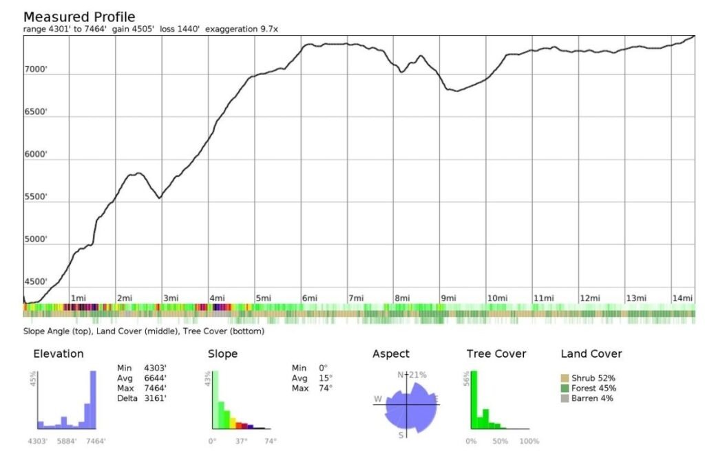
Route Profile Summary Bottom-Up
- Distance: 14 miles
- Elevation gain: 4,505 ft
- Elevation loss: 1,440 ft
- High point: ~7,464 ft
- Low point: ~4,301 ft
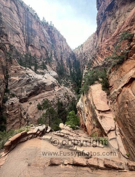
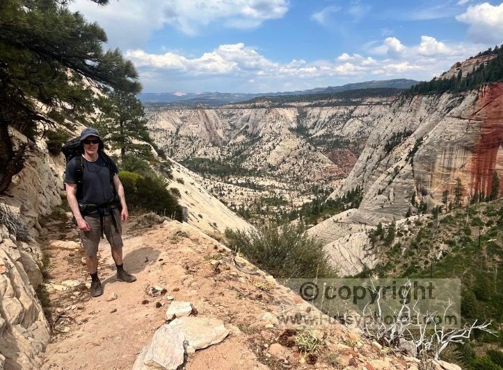
Starting from the low point around 4,300 feet, the bottom‑up route launches straight into a substantial elevation gain, with roughly 2,500 feet of climbing packed into the first few miles as you work your way up toward Scout Lookout and the benches above it. The grade is mostly steady but punctuated by short, steeper pitches that break the rhythm and make the early ascent feel committed. After this initial push, the trail begins to flatten out near Campsite 3, easing into higher, more open terrain.
A Hotter, Harder Start — But Spectacular
The Grotto Trailhead sits in the lower, hotter Zion Canyon. Roughly 2,500 of the 4,500 feet of total elevation gain come in the first five miles. It’s a big climb, but the scenery is some of the best in the American West.
For day hikers, reaching Lava Point is often unrealistic due to the distance and elevation gain. Many instead loop back south after Campsite 6 via the Telephone Canyon Trail.
Why It’s Worth Going Further
Turning around early is understandable — especially for hikers prioritizing Angel’s Landing or Scout Lookout — but pushing farther north rewards you with:
- Two excellent viewpoints
- A gradual transition from canyon terrain to high‑alpine country
- A quieter, more remote feel
Backpackers have a better chance of completing the full trail, though the extra pack weight combined with summer heat makes this direction challenging for all but the fittest hikers.
If you’re hiking bottom‑up in warm months, my Water Strategy Guide explains which springs are reliable and how much water to carry.
Route Logistics: Shuttle vs No Shuttle
Top‑Down Requires a Shuttle
In short: top‑down requires either two cars or a private shuttle. There’s no easy way around it.
Bottom‑Up: Why Many Hikers Choose It
Despite the extra elevation gain and the steep first five miles, the bottom‑up route has one huge advantage:
You can simply hike back the way you came.
No shuttle. No car staging. No complicated logistics.
The elevation loss from north to south makes the return journey a glorious, scenic descent.
Seasonal Considerations
Summer
Temperatures in Zion Canyon can exceed 100°F, making the less strenuous top‑down approach far more appealing.
Spring / Autumn
Cooler temperatures make both directions viable.
Permits may be more competitive and could dictate your schedule as much as your fitness or budget.
Snow is possible at Lava Point.
Winter
Lava Point Road may be closed, and microspikes may be needed. The scales tip toward the bottom‑up approach.
For a wider look at how winter conditions affect access, shuttles, and trail options across the park, my Zion National Park Guide offers helpful seasonal planning advice. Equally, if you decide the West Rim feels a bit too demanding for your trip, my Zion Canyon vs Kolob Canyons vs East Side Guide compares the park’s three regions and highlights easier alternatives with big views.
Water Availability
In summer, you’ll need to carry significantly more water — adding weight and making the bottom‑up approach more demanding.
Cabin Spring is less than five miles from the Grotto Trailhead, and while it usually flows year‑round, we struggled to collect more than half a quart when hiking the Zion Traverse.
Heading north (bottom‑up), the next source is Potato Hollow Spring, which is often dry by mid to late summer.

If you’re concerned about water reliability in the hotter months, the top‑down direction is the safer choice. You can comfortably start with more water, and the initial miles are gentler.
For exact spring reliability and caching advice, see my Water Strategy Guide.
Suggested Itineraries
Day Hike Options
Top‑Down Day Hike
Lava Point to the Grotto is a viable day hike for fit hikers. Start early to ensure you reach the Grotto in time for the final shuttle.
Bottom‑Up Day Hike
There are two strong options:
Out‑and‑back to Cabin Spring
- ~9.5 miles
- ~3,200 feet elevation gain
- Best in summer
- Hits many West Rim highlights
Lollipop loop via Campsite 6 and Telephone Canyon Trail
- ~15 miles
- ~3,800 feet elevation gain
- Better suited to cooler months
Overnight Options
Top‑down hikers have the most flexibility. Your main considerations are:
- How much time you have on Day 1
- How close you want to camp to Angel’s Landing for an early Day 2 start
Bottom‑up hikers will likely prefer Campsites 1–6, especially in the hotter months.
If you’re considering stretching this into a longer multi‑day adventure, my Zion Traverse Guide: Route, Itineraries and Planning Tips page walks through the full west‑to‑east Traverse in detail.
Watch West Rim Trail: Top‑Down vs Bottom‑Up — Which Direction Should You Hike?

West Rim Trail FAQs
Is the West Rim Trail part of the Zion Traverse?
Yes — the West Rim Trail forms the eastern half of the Zion Traverse. If you want the read about the full 37‑mile route, see my Zion Traverse Trip Report.
Which direction is easier: top‑down or bottom‑up?
Top‑down is significantly easier, with less elevation gain and cooler temperatures. Bottom‑up is harder but offers a rewarding climb and simpler logistics.
Do I need a shuttle for the West Rim Trail?
Only for the top‑down direction. Bottom‑up hikers can simply return the way they came.
Do I need a permit to camp on the West Rim Trail?
Yes. All nine campsites require a wilderness permit. My Permit Guide explains how to book them.
Is water available on the West Rim Trail?
Water sources are limited and unreliable. Cabin Spring usually flows, but Potato Hollow and Sawmill often dry up in summer. See my Water Strategy Guide for detailed advice.
Can I combine the West Rim Trail with Angel’s Landing?
Yes — especially if you camp at one of the lower‑numbered West Rim sites. It’s the best way to beat the crowds.
Is the West Rim Trail a good summer hike?
Yes, but the bottom‑up direction is extremely hot. Top‑down is the safer choice due to cooler temperatures at Lava Point.