It took me a long time to become aware of Goat Rocks Wilderness. While well known among Pacific Crest Trail (PCT) hikers, a Goat Rocks Wilderness hike is most famous for the dramatic Knife’s Edge section, yet it receives far less attention than nearby icons like Mount St. Helens National Monument or Mount Rainier National Park. If you’re planning a wider Washington trip or want a full overview of the park next door, my Mount Rainier Hikes — Best Trails, Backcountry Routes & Permit Tips guide covers the best entrances, regions, and iconic hikes. When planning my Goat Rocks hike, I found it surprisingly difficult to locate detailed reviews or photos of Knife’s Edge. In contrast, Hawkeye Point and Goat Lake were easier to research.
As with much of Washington State, the weather can be unpredictable—best to hope for the best and prepare for the worst. Fortunately, our visit was blessed with glorious sunshine.
Goat Rocks Wilderness Hike at a Glance
- Distance: ~21 miles
- Elevation gain: ~4,500 ft
- Highlights: Knife’s Edge, Goat Lake, Lily Basin, Hawkeye Point
- Difficulty: Strenuous
- Best season: July–September
- Trailhead: Berry Patch
Goat Rocks Wilderness Hike Overview
A Goat Rocks Wilderness hike offers a mix of alpine basins, volcanic ridgelines, and some of the most dramatic scenery in Washington. This route combines Hawkeye Point, Lily Basin, Goat Lake, and the Pacific Crest Trail for a challenging but unforgettable adventure.
Hawkeye Point, Lily Basin & the PCT Loop — The Best Hike in Goat Rocks Wilderness
There are at least 50 hikes in the Goat Rocks Wilderness, but this trip focused on Hawkeye Point, Lily Basin, and a stretch of the Pacific Crest Trail. There are several obvious options for hiking Lily Basin, and with a map and a little imagination, you can easily extend your route to explore more of the area.
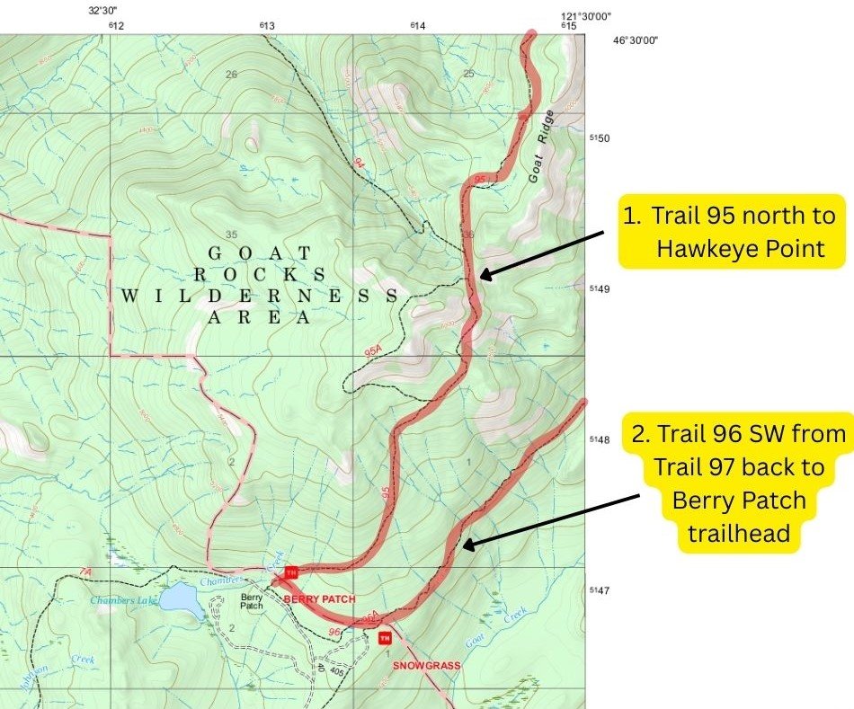
Many hikers take Goat Ridge Trail #95 to Hawkeye Point as an out-and-back, offering excellent views with relatively modest mileage. Another popular option is a loop: follow Trail #95 to Hawkeye Point, then head east via Goat Lake and Lily Basin Trail #86 before descending to the trailhead via Snowgrass Trail #96.
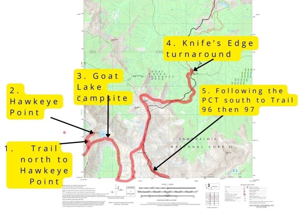
This loop formed the basis of our route, but I was determined to see more of the area while still returning to Berry Patch Trailhead. A longer loop—east on Trail #97, south on the PCT over Cispus Pass and past Nannie Ridge, then west via Walnut Lake—would require three to four days. With only two days available, we opted to hike Lily Basin Trail clockwise, connect to the PCT, and U-turn north past Old Snowy Mountain toward Knife’s Edge.
Eventually, we’d have to turn back and retrace our steps to Snowgrass Trail #96 and the car—about 21 miles in total. If I had my time again, I’d stay longer to enjoy Knife’s Edge and venture to Cispus Pass. It’s that good—I rank our hike as equal to anything I’ve seen in many national parks, including nearby Mount Rainier National Park.
Berry Patch Trailhead in Goat Rocks Wilderness — Parking, Permits & Hiking to Hawkeye Point and Goat Lake
The parking lot at Berry Patch is modest, but we found a space, grabbed our bags, and filled out the free self‑issue wilderness permit before setting off. From the trailhead, the route to Hawkeye Point and Goat Lake is less than seven miles, with around 3,100 feet of elevation gain—challenging enough to feel rewarding, yet still manageable for a late start.
Climbing to Hawkeye Point: Forests, Basins & Big Views
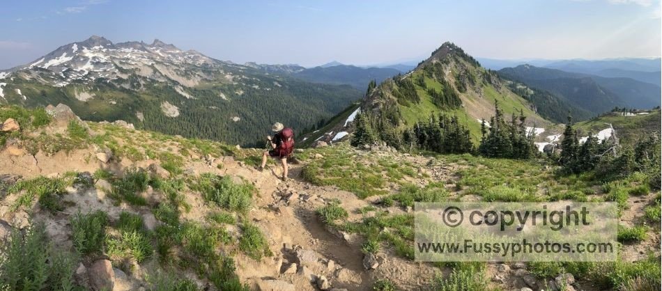
The trail begins in dense forest and climbs steeply—about 700 feet in the first mile. Water was available (filter first), but we were well-stocked. Within 90 minutes, we were nearly above the treeline, enjoying views of Jordan Basin to the west.
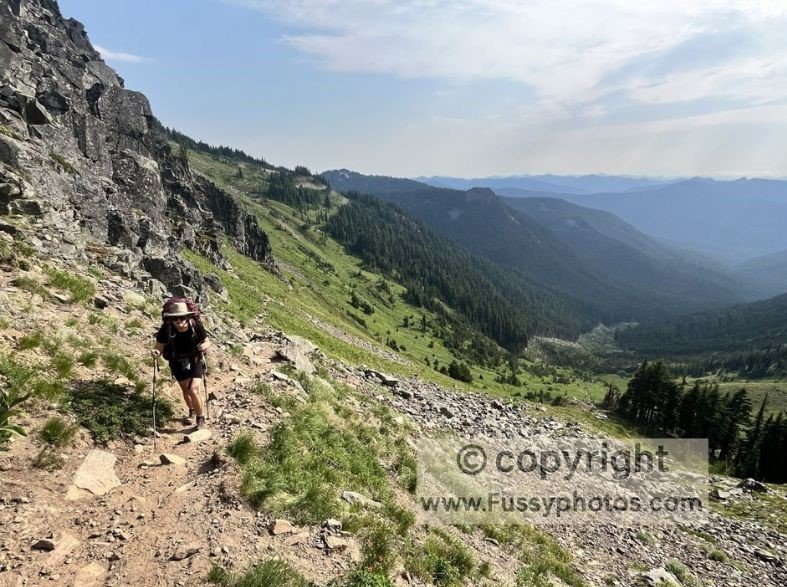
We passed a large, empty campsite beside a stream but pressed on, breathless and eager, to the top of a ridge and our first view of Lily Basin. It exceeded expectations—an elongated basin framed by a glorious U-shaped valley and snow-capped peaks.
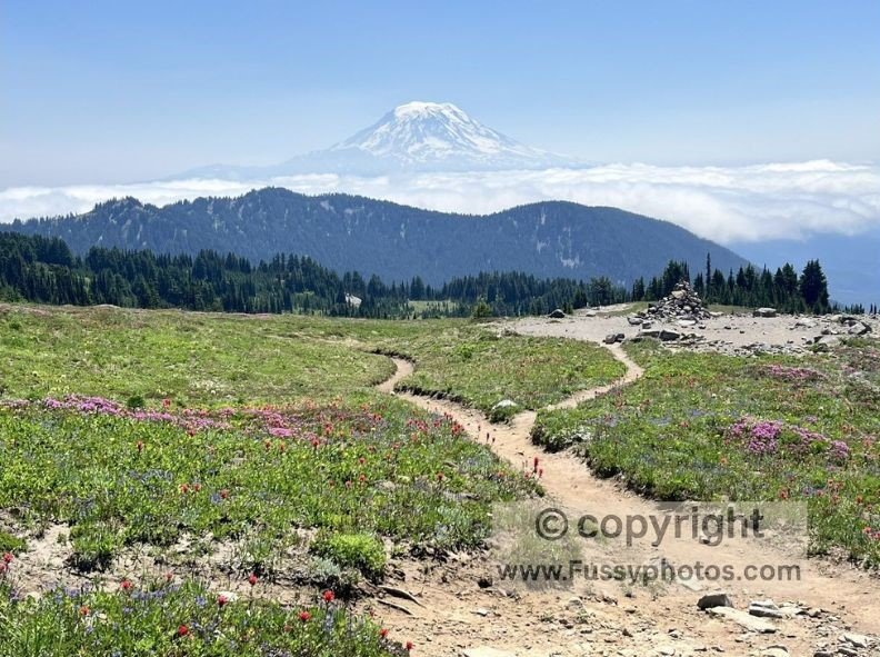
Hawkeye Point in Goat Rocks Wilderness — Can You See Mount Adams?
Reaching Hawkeye Point was exhilarating. I remembered a photo I’d seen, and excited, my senses were on overdrive as the views expanded. Mount Adams appeared behind us, its massive form unmistakable even from 22 miles away. The final ascent to Hawkeye Point was loose and steep, with no switchbacks. Leaving our backpacks behind proved wise as we climbed the top of the peak more freely.
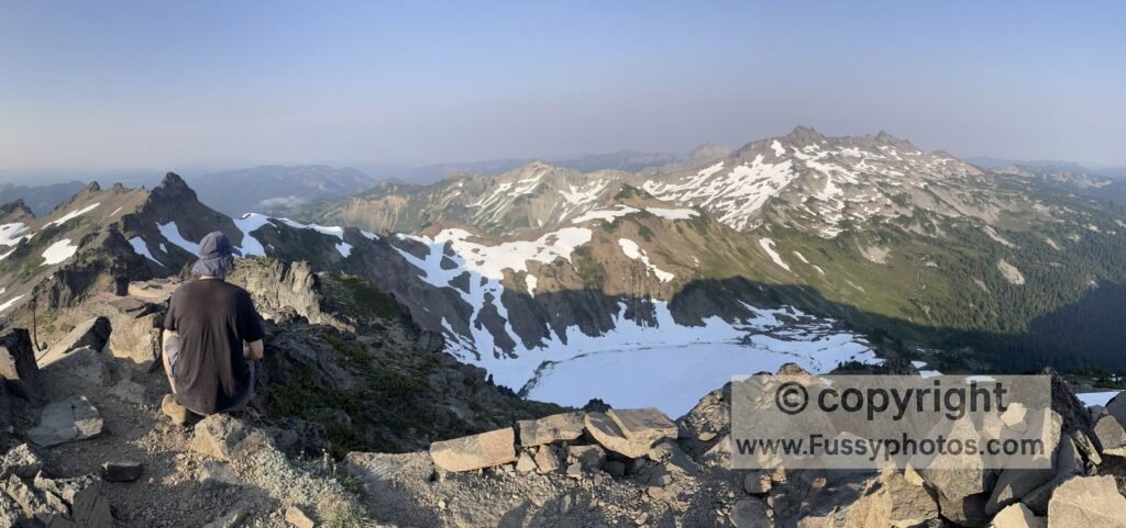
Hawkeye Point in Goat Rocks Wilderness — Can You See Mount Rainier?
At the summit, views to the north opened up, and turning south, we saw Goat Lake — completely frozen, a stunning contrast to the green valley below. The 360‑degree panorama remains one of my all‑time favorites. Even with evening haze obscuring Mount Rainier from view, it was exceptional.
Camping at Goat Lake in Goat Rocks Wilderness
On our descent, I spotted a promising campsite, but my partner cautioned against it due to exposure and potential storms. Blue skies held as we retraced the trail and turned east on Lily Basin Trail #86. Streams and ice lined the trail as we looped toward Goat Lake, with a partial sunset glowing behind us.
Goat Lake was busy, but we found a quiet patch of flat ground away from other tents and the surging streams. Even relentless mosquitos couldn’t spoil it—surely one of the most scenic campsites in the U.S.
Best Viewpoints on Lily Basin Trail in Goat Rocks Wilderness
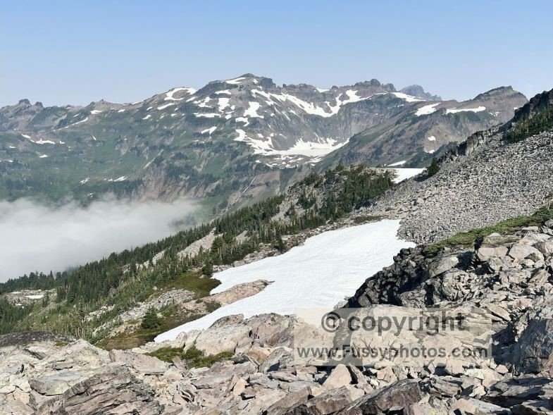
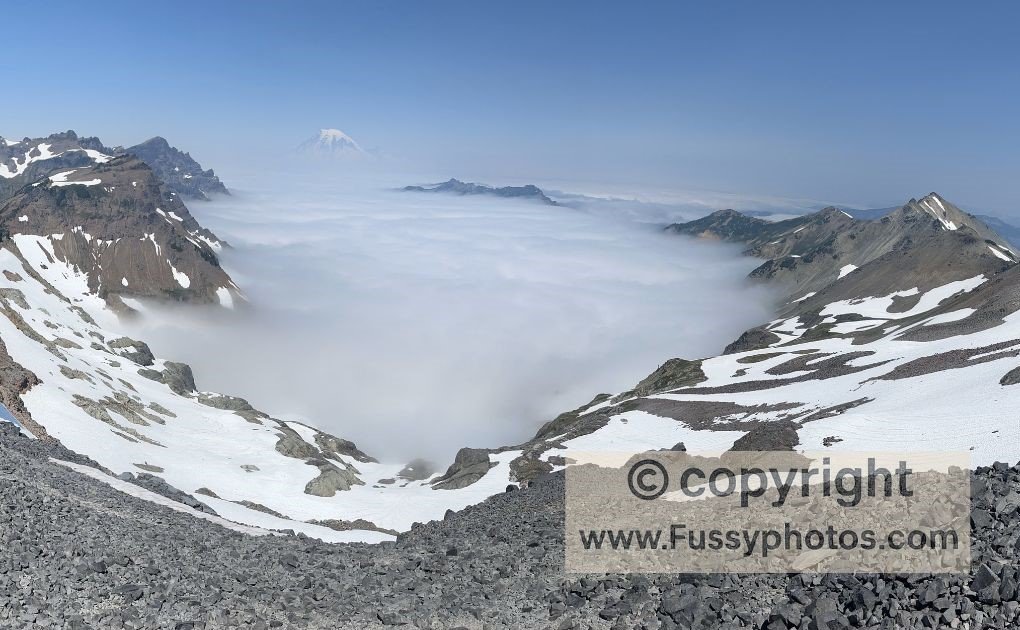
And then came one of the questions hikers always ask: where are the best viewpoints on Lily Basin Trail? We woke to clouds rolling up Lily Basin, remaining above the inversion layer. The cliffs became an island above a river of cloud. Excited, we packed up early, again greeted by mosquitos but the promise of a spectacular day.

Though the shortcut through Packwood Glacier would’ve saved two hours or so, we followed the well-maintained Trail #86 south, then turned across Snowgrass Flat to join the PCT. The trail grew busier, tents more frequent, and wildflowers carpeted the ground.
A steady incline brought Goat Lake and our campsite back into view, now bathed in sunlight. One final ascent through low shrubs revealed mountain peaks and another cloud inversion—then Mount Rainier caught my eye.
Knife’s Edge in Goat Rocks Wilderness — Can You See Mount Rainier?
A few miles of the best hiking I’ve ever done began. Knife’s Edge rose ahead, flanked by snow‑capped peaks and a massive cloud layer in the valleys below. Mount Rainier loomed in the distance, majestic and ever‑present. If I’d been asked to design a scene from scratch, I couldn’t have topped it. This was my Fussyphotos moment (see my homepage for the rationale).
Though the views tempted us further north, continuing would’ve required another overnight stay—likely near Lost Lake. Reluctantly, we turned around. Lily Basin reappeared, with Mount Adams now more prominent. Looking back one last time, the cloud layer remained, but Mount Rainier had become clearer and we took more photos.
Only when we reached Snowgrass Trail #96 and the treeline did the views fade. I stowed my camera, my thoughts turning to burgers, showers, and a bed.
Here are answers to the most common questions hikers ask about Goat Rocks Wilderness.
FAQs for Hiking the Goat Rocks Wilderness
Do you need a permit for Goat Rocks Wilderness?
Yes. Wilderness permits are required, but they’re free and self‑issued at trailhead kiosks. Be sure to fill one out before starting your hike — it’s quick, easy, and helps the Forest Service track visitor use.
How do you get to Berry Patch Trailhead?
From the Seattle area, drive south on I‑5 and take US‑12 east toward White Pass. Near Packwood, turn onto Forest Road 21 and follow signs for Goat Rocks Wilderness. The final stretch is a long gravel road leading to the Berry Patch Trailhead, but 4WD isn’t necessary in summer. Expect about a three‑hour drive from Seattle.
Is Goat Lake crowded in summer?
Goat Lake is popular and often busy, especially on summer weekends. Arrive early or camp slightly away from the main lake basin to find quieter spots.
Best viewpoints on Lily Basin Trail?
The best viewpoints on Lily Basin Trail are above the cloud inversion layer, where cliffs rise like islands. Hikers also enjoy summer wildflowers and sweeping panoramas of Mount Rainier, making it one of the most scenic sections of the Goat Rocks Wilderness loop.
Goat Rocks Wilderness Hike: Watch on YouTube

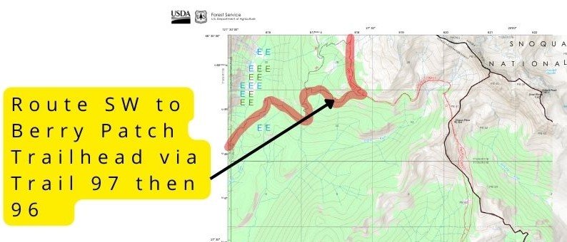
Goat Rocks Wilderness Hike Map
How Goat Rocks Wilderness fits in a road trip
Goat Rocks Wilderness makes an excellent stop on a broader Pacific Northwest itinerary, especially for those exploring Washington and northern Oregon.
- Seattle is approximately 3 hours away by car. You can reach it via Mount Rainier National Park, which lies about an hour west of Goat Rocks depending on your chosen entrance.
- Mount Rainer National Park is under an hour away. If you’re considering combining Goat Rocks with a backcountry loop in Rainier, my How to Backpack East Wonderland Trail Without Competitive Permits guide explains how to hike Indian Bar, Panhandle Gap, and Summerland without battling for the hardest permits.
- Spirit Lake, near the blast zone of Mount St. Helens, is just over 2 hours away. The Mount St. Helens Interpretive Center—a great stop for understanding the region’s volcanic history—is also a little over 2 hours from Goat Rocks.
- The magnificent Glacier National Park lies more than 9 hours east, via Spokane, and is well worth an extended stay if time allows.
Final Thoughts
The Goat Rocks Wilderness hike combines Knife’s Edge, Goat Lake, Lily Basin, and sweeping views of Mount Rainier into one of Washington’s most spectacular alpine adventures. If you enjoy high‑alpine loops with big passes and dramatic ridgelines, my High Sierra Trail Loop guide covers one of the most spectacular multi‑day routes in the American West.
Discover More Pacific Northwest Adventures
A curated guide to the best entrances, regions, and iconic routes in Mount Rainier National Park — ideal if you’re pairing Goat Rocks with a broader Washington itinerary.