Mount Rainier National Park offers some of the best hiking in the Pacific Northwest — from iconic day hikes at Paradise and Sunrise to backcountry routes on the Wonderland Trail. This guide covers the best trails, entrances, permits, and planning tips to help you choose the perfect Mount Rainier hike.
Mount Rainier – Park History and First Impressions
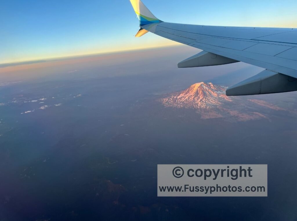
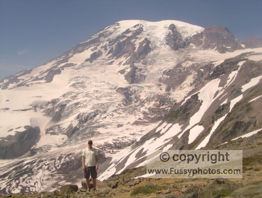
Mount Rainier National Park was the fourth designated U.S. national park, established in 1899. An active composite volcano, it is the fifth-highest mountain in the contiguous United States at 14,410 feet. Visible from Seattle and dominating the skyline for miles, Mount Rainier is an unforgettable sight. The first time I saw it was while flying into Seattle—it rose above the clouds, commanding attention. Years later on a domestic flight to Oregon, I had been glued to the window, awed by the sight of Rainier, followed by Mount St. Helens and Mount Hood. That moment cemented my determination to return for a second visit, and the following year we planned a week-long road trip through Washington State. If you too are inspired by these views, now is the perfect time to Plan Mount Rainier Hikes and experience this iconic peak up close.
The Park’s Layout and Natural Highlights
Think of Mount Rainier National Park as a large rectangle, with the volcano as its central showpiece. Surrounding it are vast glaciers, glacial meltwater streams, cascading waterfalls, alpine and glacial lakes, abundant wildlife, vibrant wildflowers, and ancient old-growth forests. With five park entrances, the 93-mile Wonderland Trail encircling the mountain, and over 260 miles of maintained hiking trails, deciding where to go can feel overwhelming—or like an exciting weekend of research, depending on your perspective.
Best Mount Rainier Hikes
Mount Rainier has more than 260 miles of maintained trails, but a handful consistently stand out as the park’s most iconic routes. These are the hikes most visitors ask about, based on National Park Service data and long‑standing popularity:
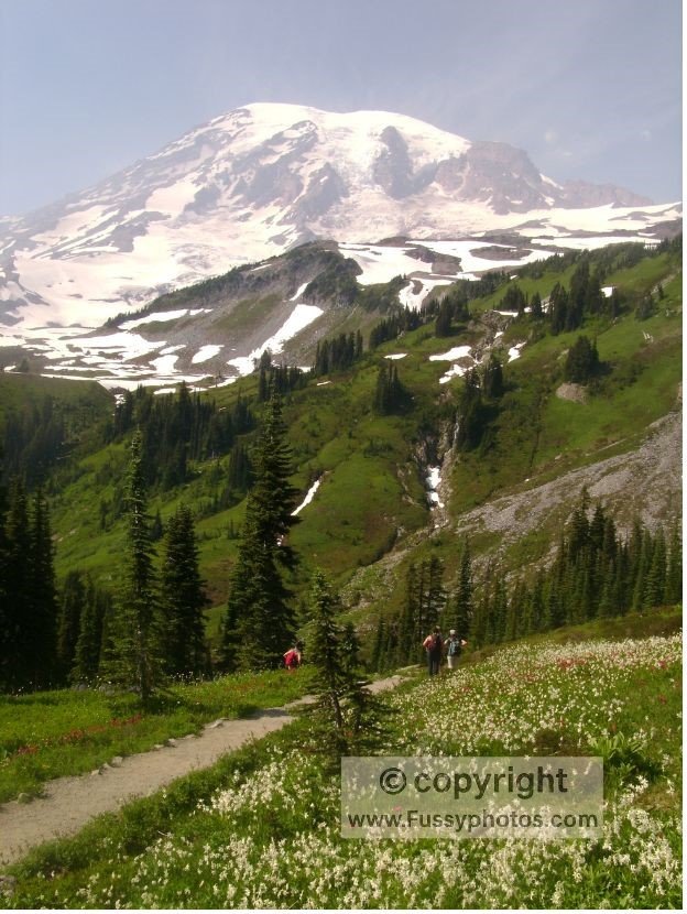
Summerland / Panhandle Gap / Indian Bar (Wonderland Trail) — glaciers, wildflowers, waterfalls, and some of the most dramatic alpine scenery in the park. One advantage of the East Wonderland backcountry route I hiked (described in my How to Backpack East Wonderland Trail Without Competitive Permits guide) is that you can experience all three of these iconic areas as part of a multi‑day loop, rather than tackling them as long out‑and‑back day hikes.
Skyline Trail (Paradise) — alpine meadows, glaciers, and classic Mount Rainier views
Tolmie Peak Lookout — a fire lookout above an alpine lake with a perfect Rainier backdrop
Sunrise Rim Trail — high‑alpine terrain with fewer crowds than Paradise
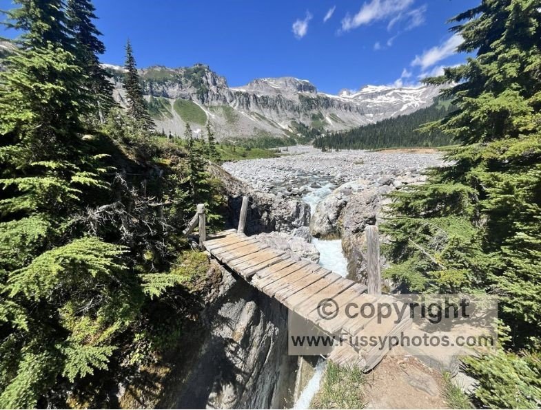
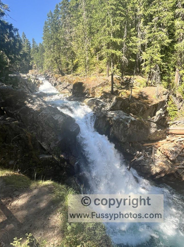
Silver Falls Loop (Ohanapecosh) — a short, family‑friendly, rewarding waterfall trail through lush old‑growth forest. I visited Silver Falls on the first day of my backcountry loop, taking advantage of its close proximity to the Cowlitz Divide Trail toward Olallie Creek, and it made for a perfect warm‑up before heading deeper into the park.
Mount Rainier Entrances Explained
Mount Rainier National Park has five main entrances, each offering access to different regions of the park. Your choice of entrance will shape your itinerary, so it’s worth planning ahead — driving from one side of the park to another can easily take half a day.
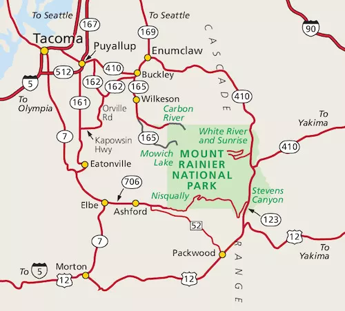
Here’s a breakdown of each entrance and what it leads to:
White River & Sunrise Entrance (Northeast)
This entrance provides access to the Sunrise area — the highest point in the park reachable by car. It’s ideal for high‑alpine hikes and expansive mountain views.
- Burroughs Mountain Trail — dramatic views of Rainier’s glaciers and summit
- Mount Fremont Lookout — a fire lookout with panoramic views
- Sunrise Nature Trail — a short loop with wildflowers and views
- White River Campground — frontcountry camping near the river
Stevens Canyon Entrance (Southeast)
Located near Ohanapecosh, this entrance is great for forested hikes, waterfalls, and access to the southeast corridor.
- Silver Falls Loop — a short waterfall hike through old‑growth forest
- Grove of the Patriarchs (currently closed for bridge repairs) — ancient trees and a suspension bridge
- Ohanapecosh Campground — shaded sites near the river
Nisqually Entrance (Southwest)
The most popular and busiest entrance, Nisqually leads to Longmire and Paradise — two of the park’s most iconic areas.
- Skyline Trail Loop — alpine meadows, glaciers, and classic Rainier views
- Nisqually Vista Trail — short, accessible loop with glacier views
- Paradise Inn & Visitor Center — historic lodge and trailhead hub
Mowich Lake Entrance (Northwest)
Accessed via a long, unpaved road that some visitors report as rough or car‑damaging. This entrance is remote but rewards with solitude and alpine lakes.
- Tolmie Peak Lookout — a scenic hike to a fire lookout above Mowich Lake
- Spray Park Trail — wildflowers and views of the north face of Rainier
- Mowich Lake Campground — backcountry access only and permit required
Carbon River Entrance (Northwest)
This entrance leads to a lush, rainforest‑like valley and is the only part of the park where biking is allowed on the old roadbed.
- Carbon River Trail — follows the old road through mossy forest
- Green Lake Trail — a short hike to a quiet alpine lake
- Ipsut Creek Campground (backcountry access only and permit required) — gateway to the Northern Loop and Carbon Glacier
Nisqually Entrance and Paradise
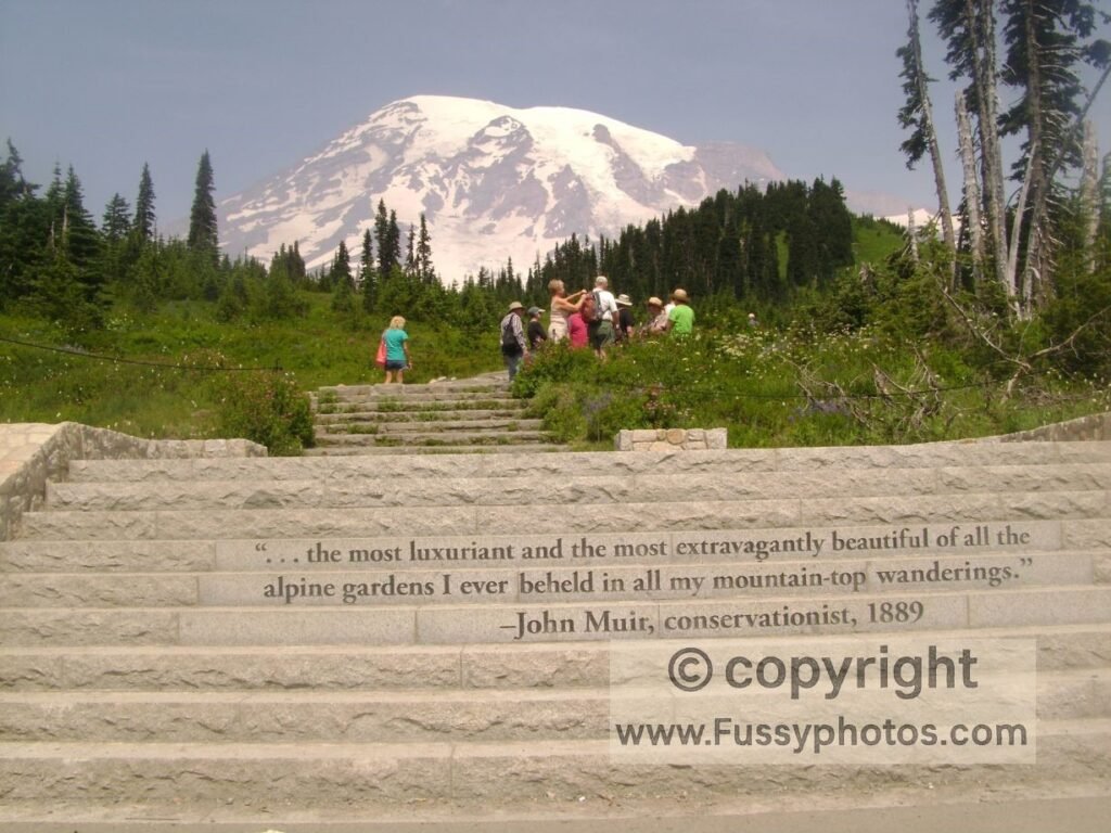
The most popular and only year-round entrance is Nisqually, accessed via State Route 706 through the town of Ashford. This route leads directly to Longmire and Paradise, making it ideal for visitors coming from the west. I used this entrance when hiking the Skyline Loop in Paradise. Paradise is justifiably busy, with John Muir famously describing it as “the most luxuriant and the most extravagantly beautiful of all the alpine gardens I ever beheld in all my mountain-top wanderings.” This visit wet my appetite and I planned to return.
Mount Rainier Backcountry & Wonderland Trail
Ohanapecosh and the Wonderland Trail
For our return to Mount Rainier, we wanted to explore Ohanapecosh, particularly Silver Falls, and sample a section of The Wonderland Trail. Our goal was to escape the crowds and enjoy some solitude. I had extensively researched the Wonderland Trail online and in guidebooks. While the full loop is a bucket-list adventure, we opted for a shorter section — both to leave time for other parts of our Washington road trip and because permits are notoriously competitive.
Mowich Lake: Scenic Rewards, Tricky Logistics
Mowich Lake was tempting, but I wasn’t keen on taking a rental car along the Carbon River Entrance road, which can be rough and has damaged vehicles in the past. While taxis can reach the area, and a point-to-point hike from Mowich Lake Campground along The Wonderland Trail sounded appealing, the logistics felt too complicated for a three-day walk. We didn’t want to lose valuable trail time navigating around the park—leaving one vehicle at our exit trailhead and spending half a day traveling to our entrance trailhead.
Stevens Canyon Entrance: A Tempting Choice, But Is It Yours?
Instead, we chose the Stevens Canyon Entrance in the park’s southeast. Our plan was to camp at Ohanapecosh Campground, visit Silver Falls, and create a circular loop off the Wonderland Trail on the park’s eastern side. During my research, two other destinations — Indian Bar and Summerland — came up repeatedly as iconic and unmissable. Both are accessible via strenuous out-and-back hikes from the Summerland Trailhead near White River Campground, another park entrance.
Mount Rainer Backcountry Permits and reservations
Backcountry camping is camping beyond developed campgrounds, where you hike, paddle, or climb into more remote areas and rely on your own skills, preparation, and gear. It offers solitude and immersion in nature, but requires careful planning, awareness of hazards, and adherence to Leave No Trace principles.
From experience, I know that hiking for hours to reach a stunning spot only to turn back immediately can feel rushed. A backcountry trip was the answer, which meant entering the Early Access Lottery for Wonderland Trail permits. Hoping to hike in summer, our odds were slim, and we didn’t secure early booking rights to craft the most comfortable itinerary before the remaining permits went on sale.
Securing Alternative Backcountry Campsites and Timed Entry Reservations
When the General On-Sale for remaining reservable backcountry campsites opened on Recreation.gov, I was ready. These sites disappear quickly, so flexibility is essential. I printed the park’s backcountry map and prepared Plans A, B, and C, knowing I’d only hike one of them. Once I secured my permits, I booked my Timed Entry Reservation, as my route might require vehicle access to the Sunrise Corridor in the park’s northeast corner. See the FAQs below for how to do this.
Wonderland Trail Reader Tip – Plan Early, Stay Flexible
If you’re planning to hike the Wonderland Trail or visit during peak summer, start your research months in advance. Be ready for permit releases, have multiple route options, and check the National Park Service website for the latest updates. Flexibility is your best friend when exploring one of America’s most spectacular and popular national parks.
Where to Stay Near Mount Rainier
Ashford (Southwest Entrance – Nisqually)
Ashford is the closest base for the Nisqually Entrance and the Paradise area, making it ideal for visitors focused on Skyline Trail and Longmire. It has the best selection of lodges, cabins, and restaurants near the park. Expect higher prices in summer and heavy traffic toward the entrance.
Packwood (Southeast Entrance – Stevens Canyon)
Packwood is the most convenient town for the Stevens Canyon Entrance and Ohanapecosh. It’s a quiet mountain community with motels, cabins, and a handful of places to eat, though even in summer we found options limited and only one spot serving cooked food in the early evening. This is the best base if you’re planning to hike Silver Falls, visit Grove of the Patriarchs (when open), or explore the southeast side of the park without the crowds of Paradise.
Enumclaw (Northeast Approach – Sunrise & White River)
Enumclaw is the main gateway town for the Sunrise and White River Entrance. It’s farther from the park boundary than Ashford or Packwood, but it offers more amenities — supermarkets, restaurants, and a wider range of lodging. It’s a solid choice if you’re targeting Burroughs Mountain, Mount Fremont Lookout, or the Sunrise Rim Trail.
Greenwater (Northeast Approach – Sunrise)
Greenwater is a tiny community along Highway 410, closer to Sunrise than Enumclaw but with fewer services. It’s a good option if you want a quieter base and don’t mind limited dining or shopping. Cabins and small lodges here are perfect for early starts on the Sunrise side.
Read My Mount Rainier Backcountry Trip Reports
Explore Indian Bar, Panhandle Gap & Summerland
If you want to backpack the east side of the Wonderland Trail without battling for the most competitive permits, this 3–5 day loop delivers glaciers, waterfalls, wildflower meadows, and some of the most dramatic alpine scenery in the park.
Mount Rainier National Park FAQs
Is Mount Rainier National Park open year‑round?
Yes, the park stays open throughout the year, but winter access is much more limited. During the snowy months, the only entrance you can drive through is Nisqually, on the southwest side of the park, which leads up toward Paradise. The Carbon River entrance remains open as well, but once you pass the boundary, the road becomes a trail and is only usable on foot or by bike. Because winter storms can close roads with little warning, it’s always worth checking the National Park Service road‑status updates before setting out.
What is the best time of year to visit Mount Rainier?
July through September is generally the most rewarding time to visit Mount Rainier, thanks to reliable weather, open trails, and the park’s famous wildflower meadows at their peak. These months also draw the biggest crowds, especially in July and August, when warm, dry conditions make the mountain incredibly popular. If you’re planning a summer trip, visiting mid‑week can make a huge difference — parking fills early, and the busiest weekends often see long waits at the Nisqually and White River entrances. Outside of peak season, the park is quieter but more affected by snow, so access and trail conditions can vary.
Do I need a reservation to enter Mount Rainier National Park?
In summer, yes — the park now requires timed‑entry reservations for popular areas like Paradise and Sunrise during peak hours. Outside peak season, no reservation is needed. Reservations and more details are available on the Recreation.gov website.
What is the best town to stay in when visiting Mount Rainier?
It depends on which part of the park you want to explore. Each town has its own character, so your ideal base depends on which entrance you plan to use and how much driving you want to do.
Ashford is the most popular base for the Paradise area, with plenty of lodges, cabins, and food options just outside the Nisqually Entrance.
If you’re heading for Sunrise or the White River side of the park, Enumclaw and Greenwater are the most convenient choices, offering easy access to the northeast entrance.
For a quieter experience near the Ohanapecosh and Stevens Canyon region, visitors often stay in Packwood, a small mountain town with good year‑round access.
Are there campgrounds inside Mount Rainier National Park?
Yes — the park has several campgrounds, including Cougar Rock, Ohanapecosh, and White River. Reservations are recommended in summer. Reservations are available on Recreation.gov.
Where are the best places to see Mount Rainier up close?
Paradise, Sunrise, and the Reflection Lakes area offer the most iconic views. Each provides trail access, visitor facilities, and panoramic mountain scenery.
What are the most popular hikes in Mount Rainier National Park?
The Skyline Trail (Paradise), Sunrise Rim Trail, and Tolmie Peak Lookout are among the most popular, offering alpine meadows, glaciers, and sweeping mountain views. For those looking for a true multi‑day challenge, the Wonderland Trail circles the entire mountain, giving hikers a full 360‑degree experience of Rainier’s forests, river crossings, and high‑alpine terrain. Permits are needed
Do I need permits for Mount Rainier’s best hikes?
Most day hikes in Mount Rainier National Park do not require permits, including popular routes like the Skyline Trail, Sunrise Rim Trail, Tolmie Peak, and other front‑country favourites.
The main exception is the Wonderland Trail, which needs both a wilderness permit and advance reservations because it’s a multi‑day backcountry route. Permits are extremely competitive. See my How to Backpack East Wonderland Trail Without Competitive Permits page for ideas.
Overnight camping anywhere in the park’s wilderness also requires a permit, even if you’re not hiking the Wonderland. For standard day hiking, though, you can simply arrive, park, and hit the trail — no paperwork needed.
For more routes across Washington, Oregon and Northern California, explore my Pacific Northwest hiking collection.