There are multiple entrance points into Kings Canyon from the Eastern Sierra, many of which allow backpackers to access the John Muir Trail (JMT) and Pacific Crest Trail (PCT)—or offer hikers already on those trails a temporary exit to resupply. One of the most popular is Kearsarge Pass, thanks to its proximity to Mount Whitney, its relatively short length (just 4.7 miles to the Kings Canyon National Park boundary), an elevation gain of just 2600 feet and its immense beauty. Even without a thru-hike itinerary, this pass makes for an exceptional out-and-back day hike in its own right.
Kearsarge Pass: Key Facts and Trail Stats
- Elevation at the trailhead: ~ 9200 feet (2800m)
- Elevation at the top of the trailhead ~ 11,700 ft (3566 m)
- Elevation gain: 2600 feet (762m)
- Trailhead: Onion Valley Campground
- One Way distances: 4.7 miles one way to the top of the pass, 7 miles to Bullfrog Lake, 8.2 miles to Charlotte Lake, 10 miles to Glen Pass (route to the popular Rae Lakes Loop)
- Popular for: Access to Kings Canyon, John Muir Wilderness, and Kearsarge Lakes
- Known for: Alpine lakes, granite peaks, and dramatic views of the High Sierra
- Kearsarge Pass permit requirements: No permit needed for a dayhike. Overnight camping requires Inyo National Forest Wilderness Permit, available from Recreation.gov. This includes the right to camp in Kings Canyon NP.
- Altitude sickness on Kearsarge Pass: This is a possibility, depending on the individual. Best practice is to camp at elevation before your hike, e.g. Onion Valley Campground or a nearby campground.
Kearsarge Pass Trail Map (U.S. Forest Service)
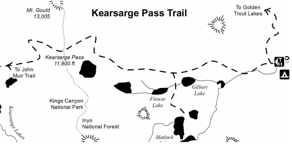
Trail map courtesy of the U.S. Forest Service, Inyo National Forest (public domain). Used for educational and informational purposes; no endorsement implied.
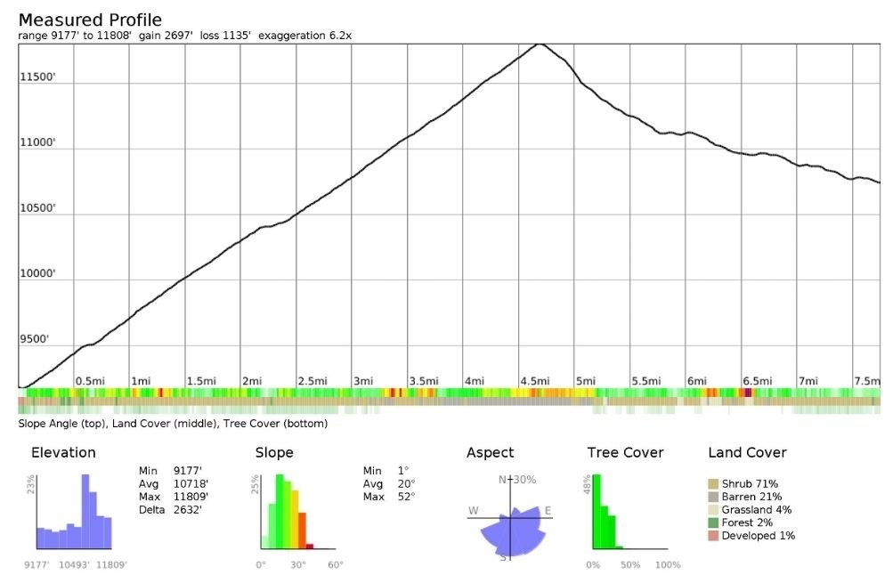
Kearsarge Pass Elevation Profile: Slope, Aspect, and Terrain
Hiking Kearsarge Pass: A Scenic Day Trip from Onion Valley
Although I’m not usually drawn to out-and-back hikes, Kearsarge Pass remains one of my all-time favorites. A high alpine gateway into Kings Canyon National Park, the pass itself is as scenic as the wilderness it leads to.
We stayed the night before at Grays Meadow, a rustic campground beside Independence Creek. It’s not as high or as close to the trailhead as Onion Valley Campground, but still sits at a respectable 6,100 feet.
I was buzzing with excitement to see Kings Canyon for the first time—until a returning hiker warned us that crampons were essential just two miles into the trail. It was mid-July, and we hadn’t packed any, nor hiking poles. Clearly, we hadn’t done our homework.
I shared my disappointment, and in a generous act of trail kindness, he offered to lend us his crampons—on the condition we return them that evening. One of many moments of generosity I’ve experienced in the Sierra.
Choosing a Turnaround Point: Lakes, Passes, and Options
Unlike many out-and-back hikes that culminate at a single summit, this trail has no fixed endpoint—just a series of tempting turnarounds. Depending on your time, fitness, and ambition, you might choose to pause at Bullfrog Lake, push on to Charlotte Lake, or even aim for Glen Pass before heading back.
Ambitious, fit, and carrying just a daypack, I hoped we might reach Glen Pass by our self-imposed turnaround time of 1:00 p.m., which I estimated would get us back before dark and before the diners closed. If you’re interested in another eastern approach into Kings Canyon, further north, you might enjoy my trip report on the North Lake – Piute Pass – Lamarck Col Loop (via JMT).
The Drive to Onion Valley and the First Miles of the Trail
The drive from Grays Meadow to Onion Valley is steep and spectacular—just 15 minutes, but unforgettable. Just before the campground, there’s a large parking lot that was nearly full despite our early start.
The trail climbs immediately, gaining about 600 feet in the first mile through open terrain with sweeping views.
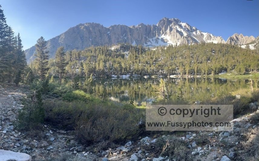
After 1.5 miles, we reached Little Pothole Lake, followed by a small boulder field with a clear route through. Then came Gilbert Lake, serene and still, reflecting snow-capped peaks and trees—yet far from the most spectacular lake of the day.
Snow, Crampons, and Unexpected Luck
The trail steepened as it climbed to the north side of the valley, still blanketed in snow from an exceptional winter. My partner strapped on the crampons while I slipped and slid behind her, relying on GPS to stay on track.
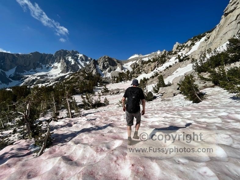
At around 11,000 feet, the trail hugged the valley wall, offering views of the partially frozen Flower Lake. Trees were sparse now—gnarled, ancient bristlecones clinging to the slope.
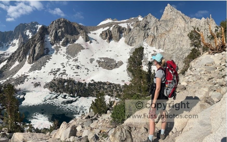
Snow continued to obscure the trail, and progress slowed. Then, in a surreal twist of luck, I spotted a second pair of crampons lying in the snow. From none to two pairs in a matter of hours—trail magic at its finest.
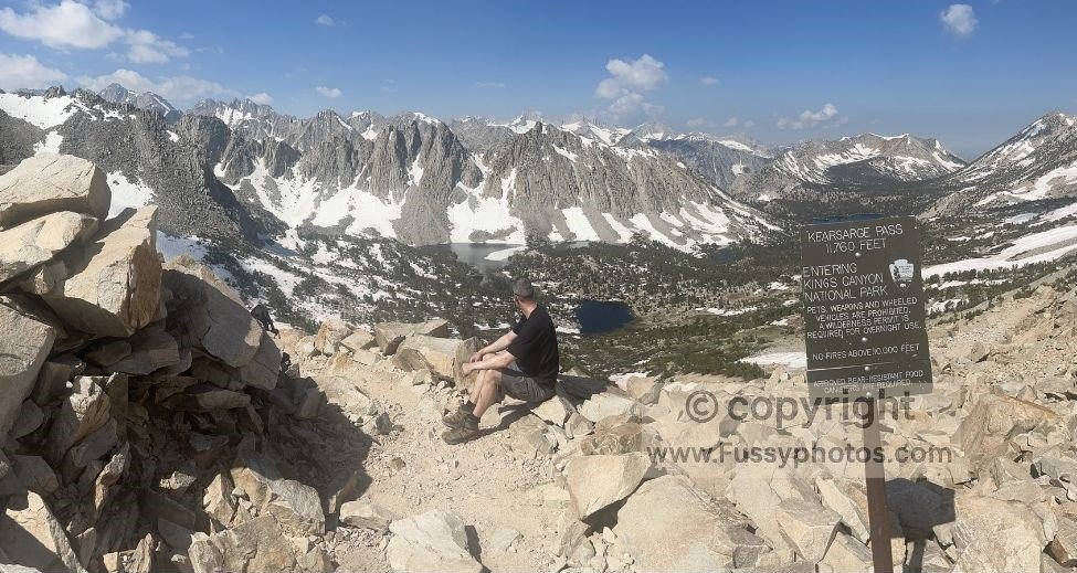
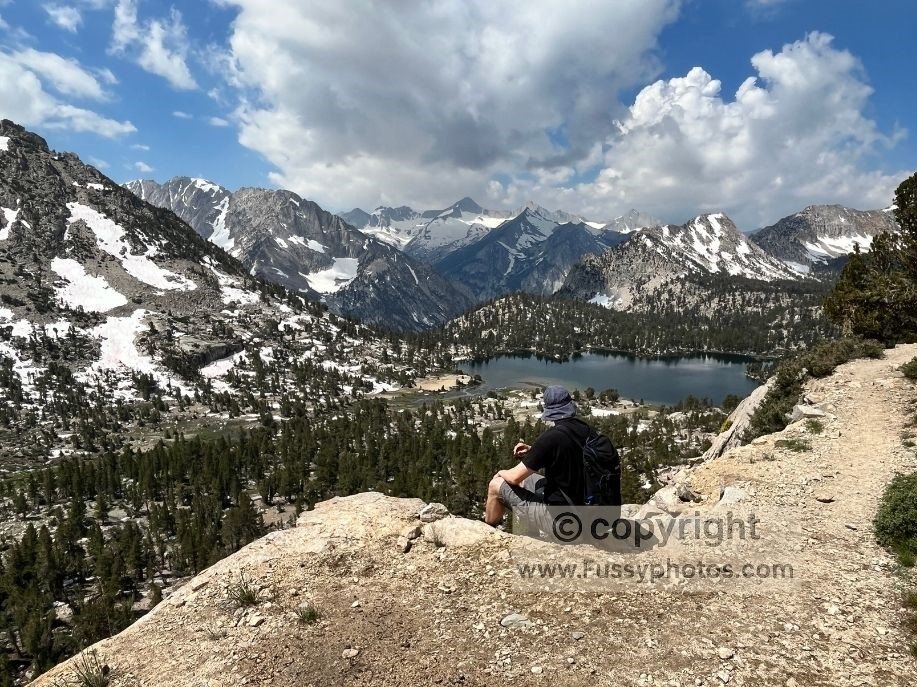
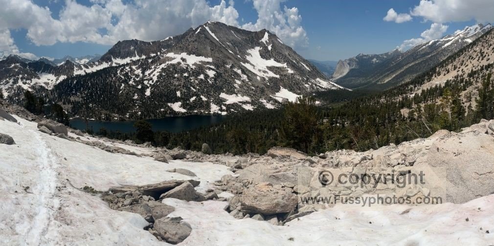
Reaching the Kings Canyon Boundary
We pressed on, passing Heart Lake, a stunning corrie tarn still frozen over. The top of the pass came into view, and soon we reached the Kings Canyon National Park boundary. The sign marked our arrival, and the view beyond was magnificent: a wide U-shaped valley filled with snow, trees, and distant lakes, framed by sharp granite peaks. It was one of those rare hiking moments I’ll never forget—easily in my top three all-time trail experiences. If you’re exploring other ways to enter Kings Canyon from the east, my Kings Canyon Entrance Passes (east): Which One to Choose guide compares all seven major approaches, including Kearsarge Pass.
Trail Karma and Canyon Views
We paused for photos and a scenic drinks break. Soon, two lean hikers arrived from the west. They’d walked from the U.S.–Mexico border, following the PCT, and were exiting to resupply in Independence. Sensing a chance to give back, we offered them sugary snacks—they looked like they needed it more than we did.
After swapping trail stories, we continued into Kings Canyon, the trail rising above the valley floor with views of Bullfrog Lake and Vidette Meadow, following the JMT and PCT southward. To our left, a massive hanging valley swept toward us, carved during the last Ice Age, offering views between East Vidette and West Vidette Peaks.
Bear Sightings and Snowfields
Around this point, my partner—leading—called out that she’d seen a bear cub. We stopped, then proceeded cautiously, making noise to avoid surprising any nearby wildlife.
Reaching the John Muir Trail, we turned north. Glen Pass was now an unlikely goal, but we were thrilled by the new views: Charlotte Lake, then another U-shaped valley with distant glimpses of Bubbs Creek. My partner chose to rest here, likely realizing I wouldn’t reach Glen Pass but too kind to say so.
I pressed on through deep snow, my feet sinking to my knees. As the trail turned east, Glen Pass came into view—rising 850 feet above me. Realizing my naivety and with our turnaround time upon us, I turned back.
A Bloody Finish and a Comfortable Return
We retraced our steps, enjoying a scenic lunch and taking more photos. The return to Kearsarge Pass was uneventful—until I fell through a snow bridge, my leg plunging to my hip and slicing my shin on sharp granite below. Blood poured, but it looked worse than it was, and we still made it back to the car in comfortable time.
Back at Grays Meadow Campground, we hoped to thank the hiker who’d lent us his crampons—but found he’d had to leave early. On his picnic table, he’d left a handwritten note with his name and address. True to trail etiquette, we packed up the borrowed gear and posted it back to him the following day—a quiet gesture to close out a day that wouldn’t have been possible without someone else’s trust.