Missed Days 1-9 of the Pennine Way?
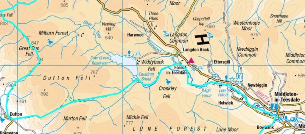
Day 10: Middleton-in-Teesdale to Dufton (21 Miles)
A Glorious River Walk, Heather in Bloom, and the Majesty of High Cup Nick
It took us another four months to return to the trail—this time, towards the end of a glorious British summer. Getting back to Middleton‑in‑Teesdale wasn’t cheap: a train to Darlington followed by a 40‑minute taxi ride. But it was the most direct and practical route, and despite three hours of travel, we were back on the Pennine Way: High Force by 10 a.m. If you’re planning this stretch in stages, my Pennine Way Train Access Guide shows every practical rail link from Middleton‑in‑Teesdale to Haltwhistle and beyond.
Heading west, this section of the Pennine Way takes you further from Scotland than where you began the day—a testament to the scenery’s calibre. It’s included not for convenience, but for sheer visual splendour.
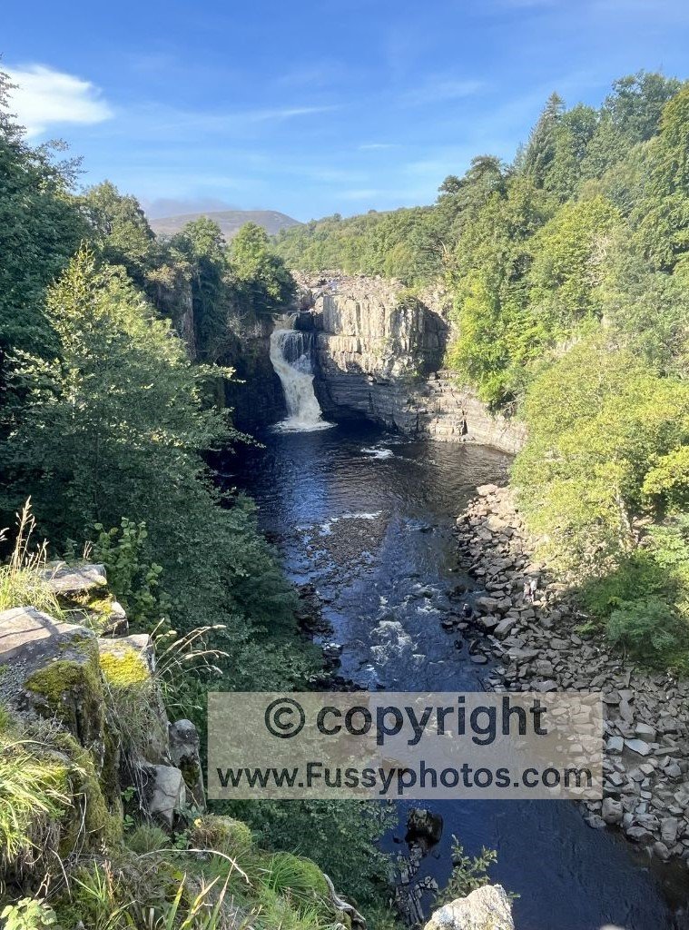
The path immediately follows the River Tees along an easy trail to Low Force and High Force waterfalls—the latter being the larger. While neither waterfall is individually spectacular, the narrow 700-metre gorge gives the scene a dramatic backdrop. Many day hikers turn back here, but they’re missing out: the day’s fine scenery continues.
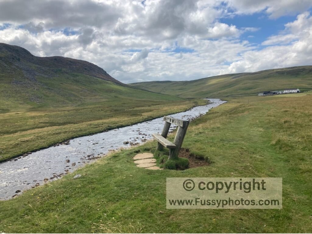
During our visit, temperatures reached 27°C— remarkably warm for this far north. The heather was in full bloom, painting the hillsides in vibrant purples and pinks. The trail continues along the upper course of the Tees, arguably the finest river walk I’ve experienced anywhere. We paused for lunch on some well-placed benches, admiring the gentle meander below.
As the valley narrows, the trail hugs the riverside, accompanied by the sound of flowing water and the scent of heather for several hours. Eventually, we reached Cauldron Snout—a waterfall where the river squeezes through a narrow gap, throwing white water with immense force. Just short of Cow Green Reservoir, the trail leaves the river (and the last of the day hikers).
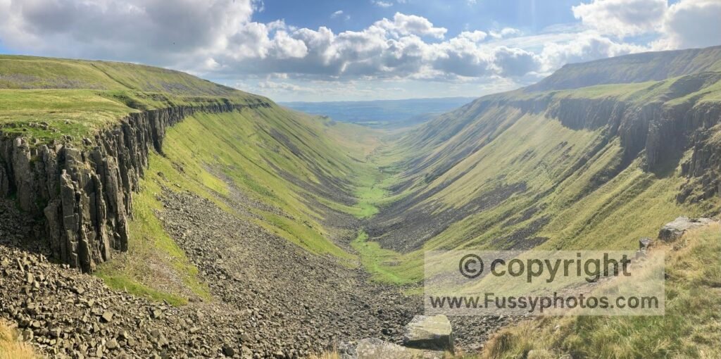
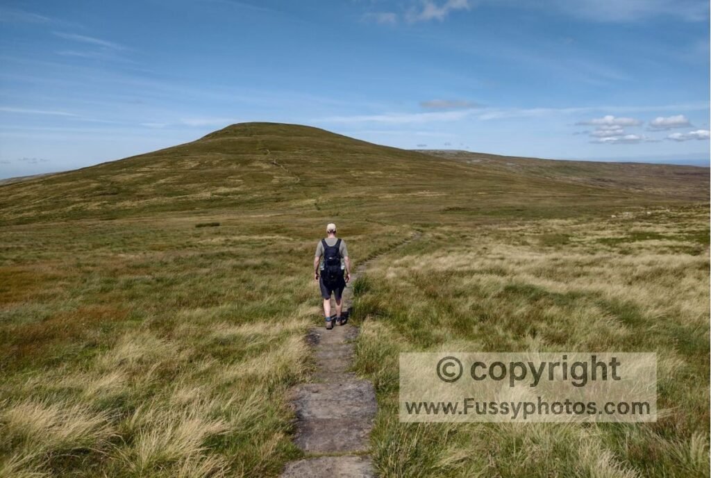
Over the next 4.5 miles, the path gently climbs until the high walls of High Cup Nick come into view—a wide U-shaped valley carved by glacial action.
The descent from here passes curious dome-shaped hills before delivering you into the charming village of Dufton.
We stayed at the youth hostel and were persuaded to order dinner—an acceptable meal, though I suspect it had been reheated. We later regretted not following our noses to the nearby campsite, where a van was serving stone-baked pizza. Instead, we ended the day with a drink at the pub, both agreeing it had been the easiest and quickest 21 miles we’d ever walked.
Day 11: Dufton to Alston (20 Miles)
Summiting Cross Fell and the Challenge of the Pennine Way’s Highest Point
Having descended into Dufton the previous evening, the trail immediately ascends again, climbing over 700 metres to reach Cross Fell (892m). With over 1,000 metres of elevation gain across the day, the National Trails website says, “Today is the toughest day on the Pennine Way.” But we smashed it, summiting Cross Fell in under three and a half hours.
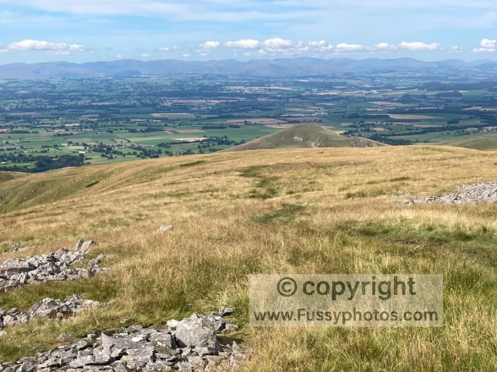
Glorious weather and distant views of the Lake District to the west kept our spirits high. I can well believe it’s a nightmare in poor conditions—this is the site of England’s strongest ever recorded gust.
After Cross Fell, the trail descends and sharply turns east. You realise you’ve climbed only to descend again, but that’s the nature of The Pennine Way. The long stretch to Garrigill is slightly monotonous, with a wide, dry track allowing us to pick up the pace. At one point, a 4WD vehicle came up behind us and offered a lift. We declined—tempting though it was—not wanting to cheat ourselves out of any miles.
Beyond Garrigill, my memories are of a trail following the valley, with the River South Tyne flowing below. Alston offers good facilities, and we had our pick of pubs and restaurants to round off the day.
Soggy Logic & the Triumph of Overpacking
For reasons I can’t remember, I was walking the UK’s toughest trail in the worst walking boots imaginable. With worn threads and zero waterproofing, they were next to useless—yet I hadn’t come round to buying new ones. The number of times I’d start a day with dry socks, only to walk the next 14-plus miles with wet feet, amazes me when I look back—and stands in sharp contrast to how I prepare these days.
The obvious solution was to buy new walking boots. My solution, however, was to add extra weight to my already lop-sided bag by lugging around a pair of wellies—because nothing says “prepared hiker” like dragging farm footwear across the Pennines. And yet, even in the midst of a glorious heatwave, the path to Cross Fell was still four inches underwater. For the next hundred metres, I put on my boots and kept my feet dry. Full justification for adding all that weight to a 57-mile leg, I’m sure you’ll agree. Never mind that the wellies spent the other 56.9 miles sulking in my pack.
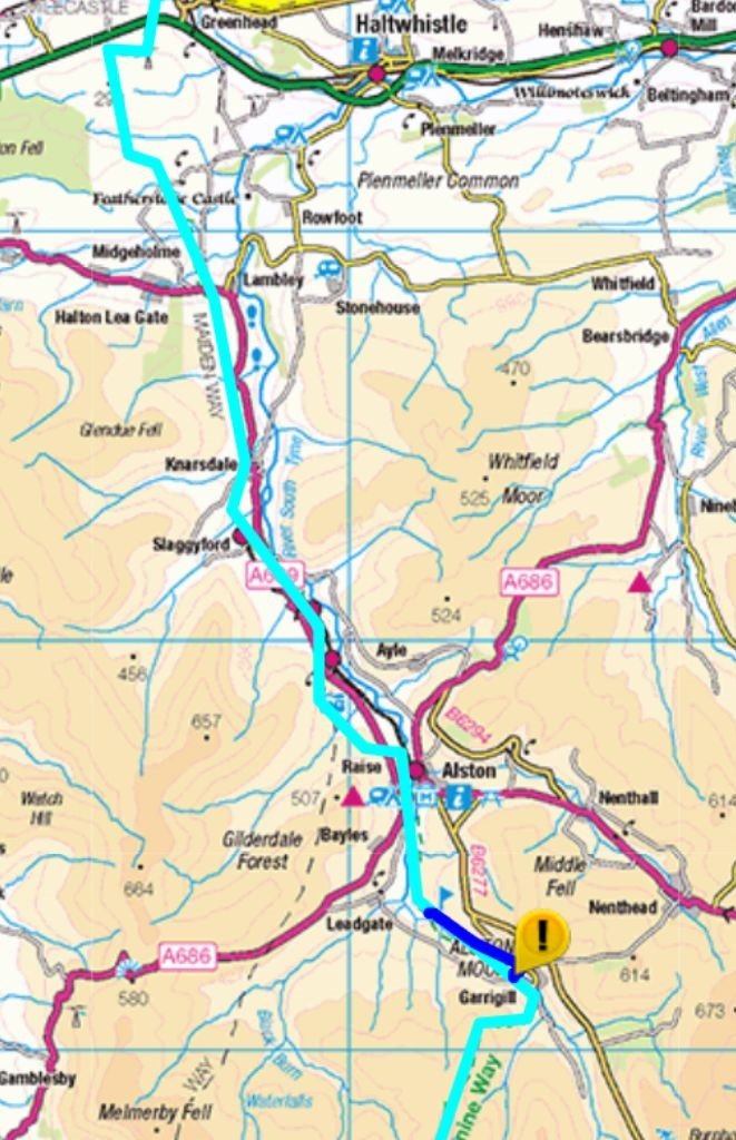
Day 12: Alston to Haltwhistle (15 Miles)
Low Expectations, Fine Weather, and a River-Side Surprise
After two demanding days, we were definitely moving a little slower. My expectations were low. The National Trails website doesn’t mince words, practically apologising for it:
“Today is unlikely to be in anyone’s Pennine Way Top Five. Or Top Ten. Or even Fifteen. In fact, it could be your least favourite day.”
I have few photos from this stretch, suggesting a lack of open views and striking landforms. Yet around the halfway point, we both commented on how much we were enjoying ourselves. Fine weather certainly helped, and the trail—though understated—had its own quiet charm.
As we left the Way in search of our train station, the day became memorable for the number of families swimming in the river, soaking up the balmy conditions. We had time for a drink while awaiting our train—Haltwhistle being conveniently located on the Carlisle to Newcastle line—and then a second pint when our first train was cancelled, extending our wait by another hour. At this point, it was unclear whether we were celebrating the end of our walk or settling in for a new one: The Pennine Way, Part II — The Long Walk Home.
Pennine Way Route Maps | Days 10–12: Middleton‑in‑Teesdale to Haltwhistle
Pennine Way Days 10-12 FAQs
What’s the total distance for Days 10–13?
Approximately 78.5 miles:
- Day 10: 21 miles
- Day 11: 20 miles
- Day 12: 16.5 miles
- Day 13: 22 miles
What is the walking like along the River Tees?
Glorious. It’s one of the finest riverside walks in England: meanders, heather, wildflowers, and a soundtrack of flowing water. Wainwright called it “a walk of near perfection.”
What makes High Cup Nick so special?
It appears suddenly after miles of gentle climbing — a vast U‑shaped valley carved by ice, with sheer cliffs and sweeping views. Many hikers consider it the single best sight on the entire Pennine Way.
Can you break Day 10 into two days?
Yes. Forest‑in‑Teesdale and Langdon Beck are both just off‑route and offer accommodation. They split the day nicely, though some hikers feel they come a little too early.
Why does Day 10 take you further from Scotland?
Because the Pennine Way swings west‑south‑west to reach High Cup Nick. You end the day physically further from Kirk Yetholm than when you started — but the detour is absolutely worth it.
How hard is the Dufton to Alston section?
Very hard. It’s often described as the toughest day on the Pennine Way: 20 miles, over 1,000 metres of ascent, and three major summits including Cross Fell, the highest point on the trail.
What makes the Dufton to Alston section so challenging?
Exposure, distance, and navigation. The high fells can be brutal in bad weather, and Cross Fell has a reputation for fog, wind, and sudden changes. Even in good conditions, it’s a big day.
Is Greg’s Hut open to walkers?
Yes — it’s a famous bothy on the route between Dufton and Garrigill. It offers shelter, a place to rest, and a bit of Pennine Way history. Some hikers even overnight there.
Why is Day 12 considered one of the least exciting Pennine Way stages?
Because it lacks big views and standout landmarks. The route zigzags through fields, farms, and bogs, and navigation can be fiddly. But it’s still a decent day in fine weather.
Is Greenhead a good place to stop?
Yes. It’s a small but useful village with accommodation, a pub, and access to Hadrian’s Wall. It’s also a natural transition point between the Pennines and the Roman frontier.
How hard is the Greenhead to Bellingham section?
Hard. It’s 22 miles with lots of steep ups and downs along Hadrian’s Wall — the third‑highest total ascent of any Pennine Way day. Your calves will feel it.
What makes the Hadrian’s Wall section so special?
Eight miles of world‑class scenery and history. You walk beside dramatic crags, Roman forts, and some of the most iconic stretches of the Wall. It’s busy, but unforgettable.
What are the highlights of Days 10–13?
High Force, Cauldron Snout, High Cup Nick, Cross Fell, distant views of the Lake District, Greg’s Hut, the quiet charm of Day 12, and finishing at Hadrian’s Wall.
Continue Reading
Explore all my Pennine Way routes, trip reports and planning guides in my Pennine Way Hub
If you’re interested in another classic UK long‑distance route, you can start the Coast to Coast with Day 1 from Robin Hood’s Bay.