A Better Helvellyn Route via Grisedale Valley and the Coast‑to‑Coast Path
Voted Britain’s favourite walk in ITV’s Top 100, the route up Helvellyn is well documented. If you enjoy the Lake District’s big‑name routes, the nearby Cat Bells Circular Walk is another brilliant option with huge views for relatively little effort. Never much of a peak‑bagger, I decided to find a better Helvellyn route — my own circular line up England’s third‑highest mountain rather than follow the shorter, more tried‑and‑tested options.
As a keen long‑distance walker — having completed the nearby Pennine Way — I’d noted a longer but more scenic line along the infamous Coast‑to‑Coast Path, climbing through the glaciated valley of Grisedale after beginning in Glenridding. The route proved even better than expected, with Grisedale Valley offering solitude and superb mountain scenery all the way to Grisedale Tarn. From here, I’d approach Helvellyn from the south, avoiding the notoriously dangerous Striding Edge and Swirral Edge for a less hair‑raising ascent.
Glenridding to Grisedale Valley
Even with a fair forecast, it’s wise to prepare for the worst on the Lake District’s highest peaks. Beginning in Glenridding — after spending what felt like a day’s wages on parking (I’m convinced the machine winked at me) — I noted the low cloud and decided to tackle Grisedale first, giving the weather time to behave itself.
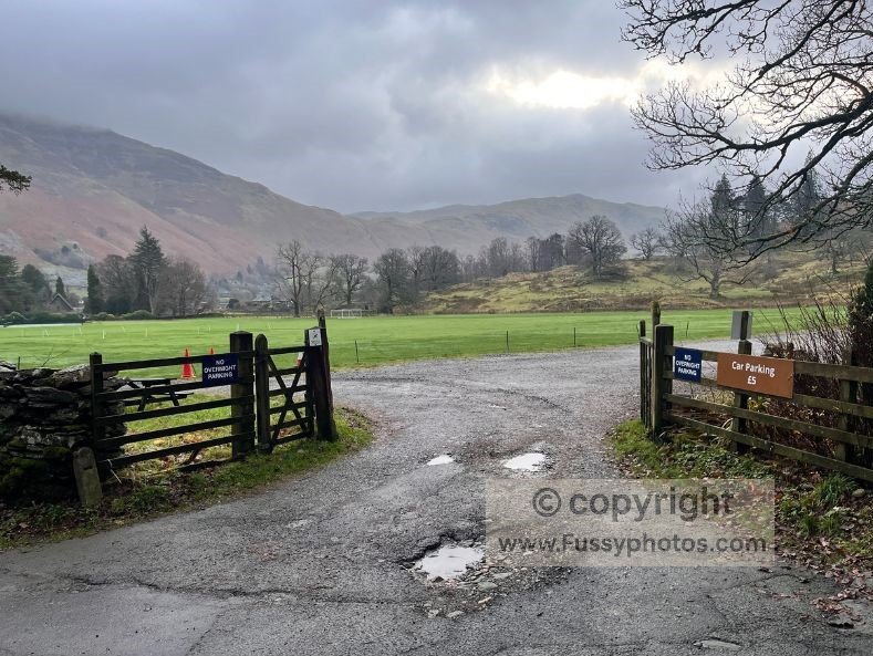
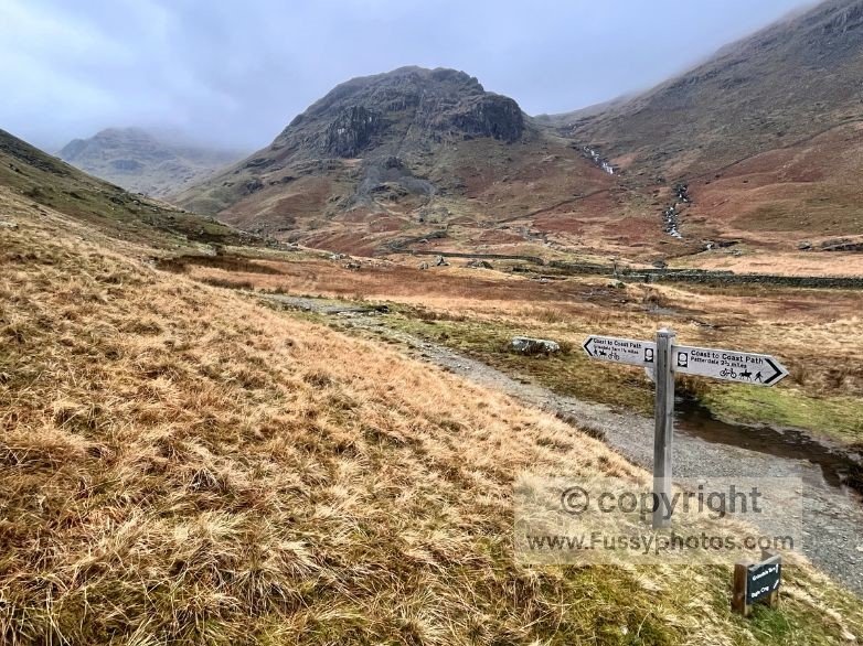
It’s flat, gentle, paved walking from Glenridding to Patterdale Hall and the right turn off the A592 before Grisedale Bridge. The road follows the roar of Grisedale Beck, which was in full voice after a week of heavy rain. Soon the tarmac peters out and the Coast‑to‑Coast Path leads you into a scenic valley lined with drystone walls and running water — the kind of place that makes you briefly forget you paid £9 to stand here.
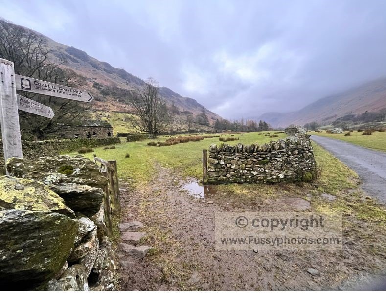
Coast‑to‑Coast Path to Grisedale Tarn for a better Helvellyn Route
The route is attractive and well marked, with the scenery growing increasingly dramatic as you head south‑west, parallel to Striding Edge high above.
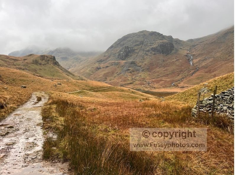
The trail becomes progressively rugged and steep as you follow the valley towards Grisedale Tarn, crossing the beck over wooden bridges more than once as you near Ruthwaite Lodge (Climbing Hut).
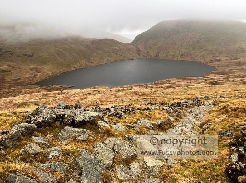
The wind picked up noticeably and, despite a good pace, I added layers. Grisedale Tarn is one of the more impressive tarns in the Lakes, with Seat Sandal looming above like it’s judging your fitness choices.
Leaving the Coast‑to‑Coast Path, the route to the right climbs on paving stones — a staircase into the clouds.
I lost the views around 700 metres, which was a shame, because I’d been looking forward to them. Instead, I got mist, drizzle, and the vague sense I’d paid for the premium package but accidentally selected “basic”.
Ascent into the Clouds: Approaching Helvellyn from the South
Despite some wishful thinking, the cloud didn’t lift, nor did I climb above it to enjoy an inversion. Instead, the ascent became a rocky treadmill with all the excitement of a damp Tuesday. Cairns confirmed I was among the highest people in England at that moment, though you wouldn’t know it — visibility was roughly the length of my arm.
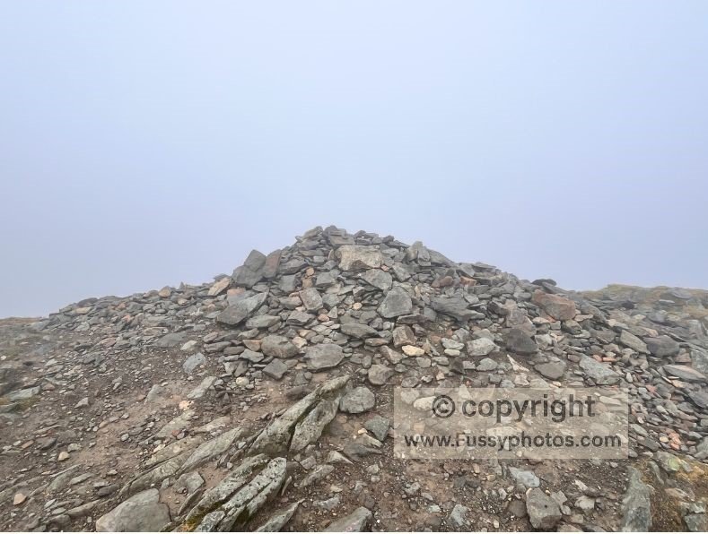
The edge of Helvellyn is steep, and I stood at the top of Striding Edge imagining what it must look like on a clear day.
Resisting the temptation to descend the glacial arête, I continued north along the ridge.
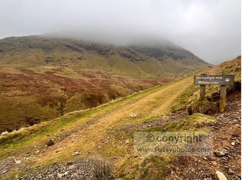
Helvellyn to Whiteside and Glenridding Common
The trail north of Helvellyn descends — and at times annoyingly rises again, as if mocking your optimism — before reaching Whiteside (836 metres). Here the path forks. Taking the right‑hand option leads towards Glenridding Common.
In better weather, this stretch offers sweeping views of Catstye Cam, Red Tarn, Swirral Edge and Striding Edge. I saw… grey. Lots of grey. But around 600 metres, after a painfully steep descent, I finally dropped below the cloud and the views returned.
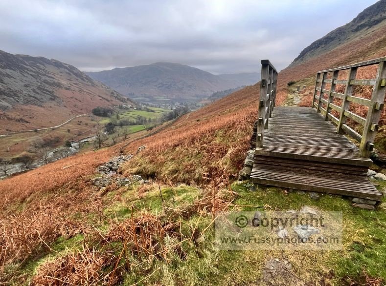
Descent Along Glenridding Beck
Heading north‑east, the trail runs beside Glenridding Beck — another gloriously noisy stretch of water thundering off the mountains. The scenery is superb: steep slopes, waterfalls, the beck itself, and scenic wooden bridges as Glenridding comes back into view.
A Better Helvellyn Route: A Worthy Alternative to the Classic Helvellyn Routes
Though I didn’t come away with the hero shots of Helvellyn — unless you count “grey void” as a genre — this is a fantastic loop and a quality alternative to the more trodden out‑and‑back routes. At a good pace and with little rest, I completed the 11.5‑mile circuit in around 5.5 hours.
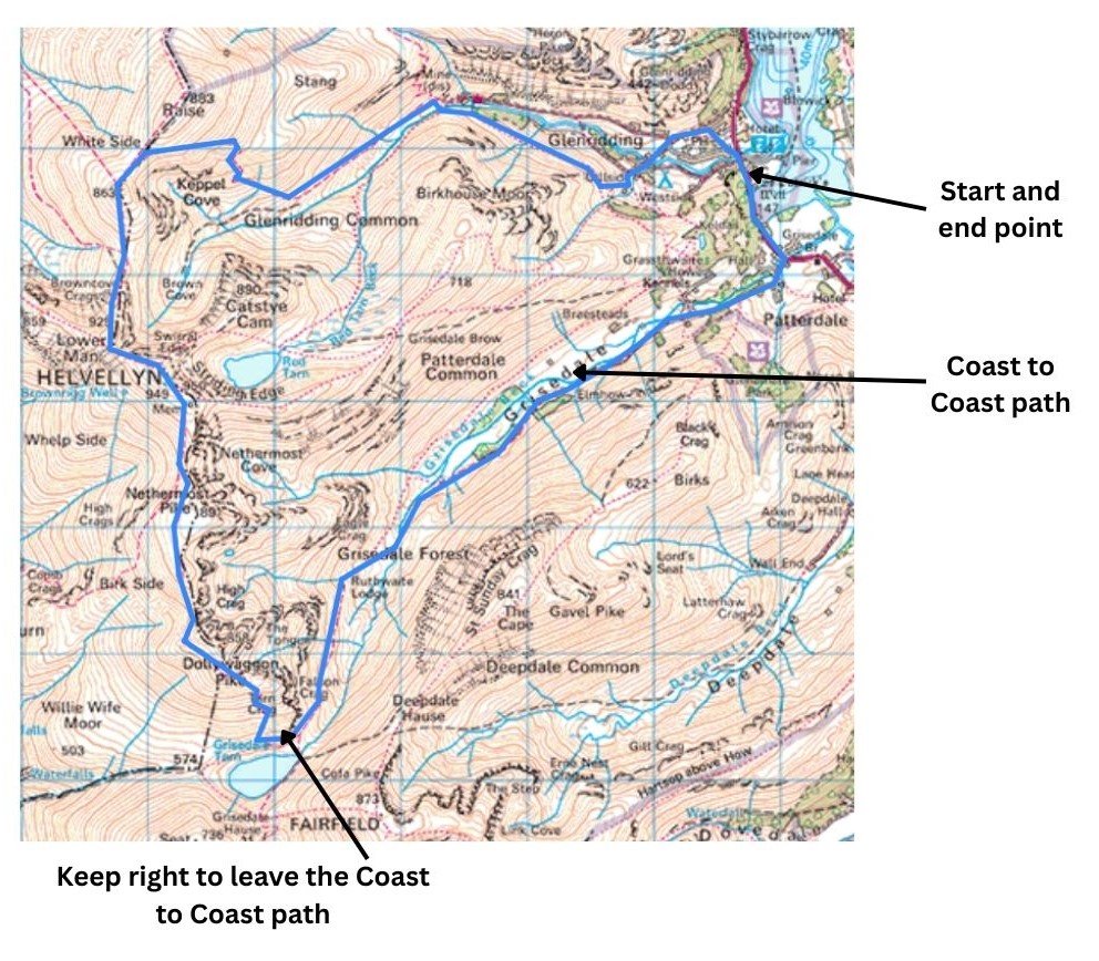
A Better Helvellyn Route Map
Watch the Video: A Better Helvellyn Route

What I’d Do Differently Next Time – a Self‑Deprecating Reflection
Check the weather forecast with something more reliable than blind optimism.
I went in with the confidence of someone who believed the clouds would “probably lift”. They did not. Next time, I’ll trust actual meteorology rather than vibes.
Bring gloves, even if it looks warm in the car park.
The Lake District has a charming habit of dropping ten degrees the moment you gain 200 metres. My hands spent an hour resembling two undercooked fish fingers.
Remember that Helvellyn is not, in fact, flat on top.
The ridge undulates in a way that feels personally targeted. Next time, I’ll mentally prepare for the “surprise” uphill sections instead of acting betrayed every time the path rises again.
Accept that Striding Edge will still be there on a clear day.
I didn’t descend it this time, which was wise. But I did stand at the top imagining myself doing it — which was less wise. Next time, I’ll save the daydreaming for when I can actually see where my feet would go.
Pack a sense of humour.
Because when the cloud steals your views and your photos, it’s the only thing that keeps the walk enjoyable!
What I Definitely Wouldn’t Change – in My Humble, Questionable Judgement
Starting in Glenridding.
Yes, the parking is daylight robbery, but it’s also the perfect launch point — and the sooner you accept the fee, the sooner you can pretend it’s “supporting local infrastructure” rather than draining your wallet.
Taking the long way up Grisedale Valley.
It’s quieter, more scenic, and blissfully free of the Striding‑Edge‑or‑bust crowd. Even on a cloudy day, it feels like you’ve chosen the connoisseur’s route — which is far more satisfying than admitting you’re avoiding the scary bits. And if you prefer something shorter but still packed with scenery, the Cat Bells Circular Walk is a fantastic nearby option
Skipping Striding Edge in bad weather.
Some call it caution; I call it survival instinct. There’s no shame in choosing the route that doesn’t involve clinging to wet rock while questioning your life choices.
Making it a full loop.
There’s something deeply satisfying about returning to your starting point under your own steam — especially when the alternative is trudging back the same way you came, wondering why you didn’t plan better.
What I Packed (and What I Pretended I Packed)
Waterproofs
Because the Lake District enjoys surprising you with weather you definitely didn’t order. Mine stayed on for most of the day, which I’m choosing to interpret as “good planning” rather than “inevitable”.
Layers
I brought several. I wore all of them. At one point I considered adding the map as insulation.
Decent boots
Essential for the rocky sections and for maintaining the illusion that I know what I’m doing.
A camera
To capture the stunning views I absolutely did not get. Still, it’s important to have one — you never know when the cloud might briefly part, or when you’ll want to photograph a particularly photogenic rock.
A map and compass
Used mainly for reassurance, since visibility was roughly the length of my arm. Still, nothing boosts morale like pretending you could navigate without the path.
A wildly optimistic belief that the weather would improve
Not technically gear, but I carried it the whole way. It was heavy.
A Better Helvellyn Route FAQs
How high is Helvellyn?
Helvellyn stands at 950 metres, making it the third‑highest peak in the Lake District and one of the most iconic mountains in England
Is Helvellyn suitable for beginners?
Helvellyn can be suitable for fit beginners if they avoid Striding Edge and Swirral Edge, which are exposed Grade 1 scrambles. Safer alternatives include routes from Glenridding or via Grisedale Valley and my A Better Helvellyn Route.
Why is Helvellyn so popular?
It’s a “bucket‑list” mountain thanks to its dramatic ridges, panoramic views, and the famous Striding Edge. It’s consistently rated as one of Britain’s top walks.
Is Helvellyn dangerous?
It can be. Weather changes rapidly, and the exposed ridges require experience. Even the easier routes demand proper gear, navigation skills, and good conditions
What is Striding Edge?
Striding Edge is a narrow, exposed arête leading to Helvellyn’s summit. It’s one of England’s most famous Grade 1 scrambles
Is Striding Edge safe?
It’s only recommended for experienced hikers with a head for heights. Falls have occurred here, and it should be avoided in poor weather, high winds, or winter conditions
How long does Striding Edge take?
Most walkers take 1–2 hours to traverse the ridge, depending on confidence and conditions. The scramble requires hands‑on movement and careful footwork
Where is Grisedale Valley?
Grisedale Valley runs south‑west from Glenridding towards Grisedale Tarn. It’s part of the Coast‑to‑Coast Path and offers a quieter, scenic approach to Helvellyn
What is Grisedale Tarn?
Grisedale Tarn is a remote mountain lake sitting between Seat Sandal, Dollywaggon Pike, and Fairfield. It’s a dramatic landmark on the Coast‑to‑Coast Path.
Where is Glenridding?
Glenridding is a village on the eastern shore of Ullswater and one of the most popular starting points for Helvellyn routes
Humorous FAQs
Did I choose the longest possible way up Helvellyn on purpose?
Absolutely. Some people chase summits; I apparently chase unnecessary mileage. It builds character. Or blisters. Sometimes both.
Why didn’t I take Striding Edge?
Because I enjoy being alive. Also because visibility was roughly “inside a ping‑pong ball”, which isn’t ideal for ridge‑walking unless you’re actively trying to meet Mountain Rescue.
Was the cloud really that bad?
Let’s put it this way: I could’ve been anywhere. Helvellyn, Ben Nevis, the inside of a steam room — all equally plausible.
Did I get any good summit photos?
Define “good”. If you enjoy abstract grey rectangles, then yes — I absolutely nailed it.
Is Grisedale Valley really worth the detour?
Yes. It’s quieter, scenic, and blissfully free of people loudly debating whether Striding Edge is “actually that bad”. Spoiler: it is, in bad weather.
Was the descent into Glenridding as steep as it looked?
Steeper. My knees filed a formal complaint halfway down.
Would I do this route again?
Absolutely. Preferably on a day when I can see more than three metres ahead. But yes — it’s a brilliant loop, even if the weather occasionally tries to gaslight you.
Should you follow my route?
Yes — it’s genuinely a better Helvellyn route. Just bring layers, snacks, and realistic expectations about the weather’s sense of humour.