Missed Days 1 & 2? Backpack the High Sierra Trail Now: 5‑Day Loop
Day 1: Lodgepole – Bearpaw Meadow.
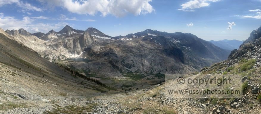
Day 2: Bearpaw Meadow – Hamilton Creek Basin
Note: This trip report was originally published as the High Sierra Trail Loop. I now use the name Hamilton Basin Loop—an unofficial but more accurate description of this 5‑day circuit, which only overlaps part of the High Sierra Trail. The H1 titles remain unchanged for continuity, and readers planning their own variation of the route can find practical guidance in my Hamilton Basin Loop trip‑planning guide.
Hamilton Basin Loop Route Map
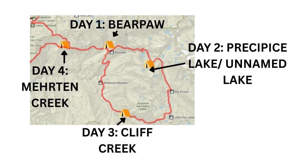
Base map courtesy of the National Park Service (NPS), annotations by Fussyphotos (Jack).
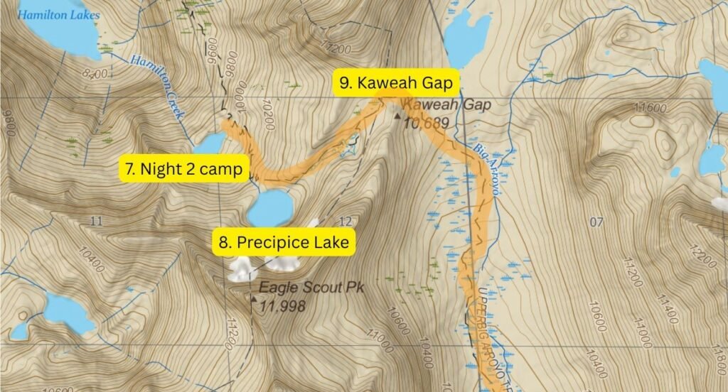
Day 3 Route Map: Hamilton Lake Basin to Cliff Creek Campground
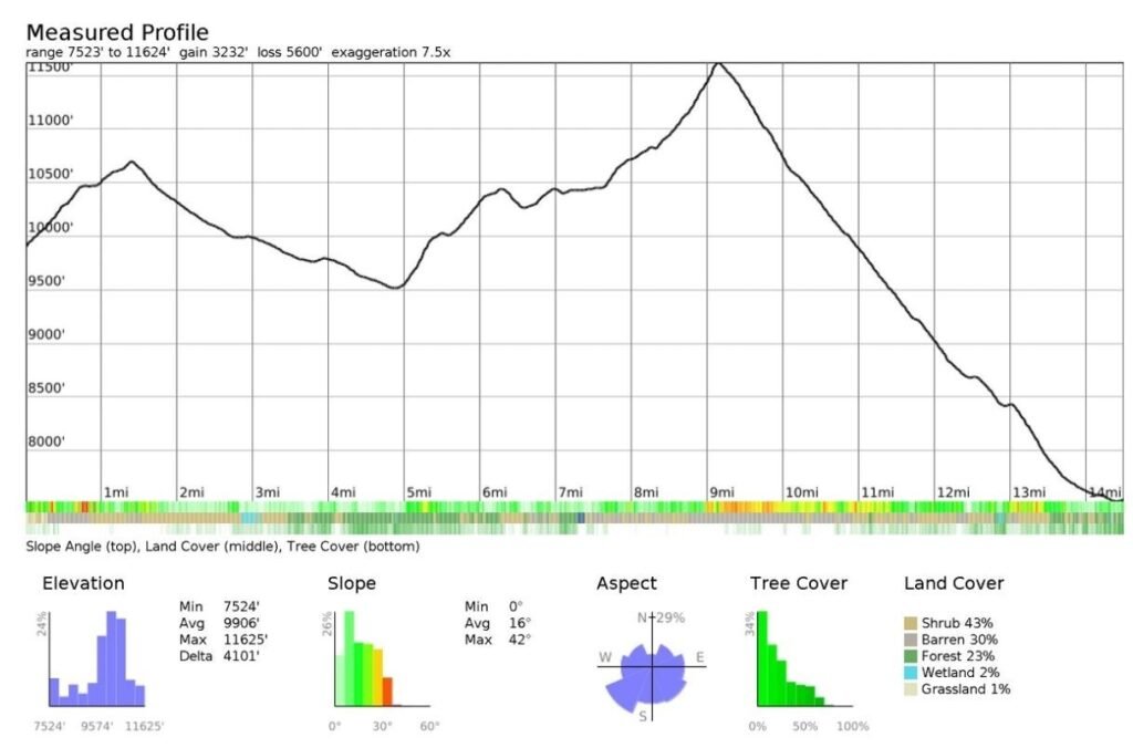
Day 3 Elevation Profile
Day 3 on the Hamilton Basin Loop: Hamilton Lake Basin to Cliff Creek
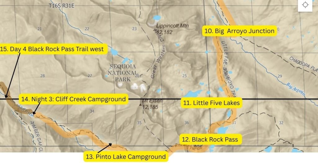
On paper, today was our longest day on the Hamilton Basin Loop. Having not continued to Precipice Lake, tonight’s campground—Cliff Creek backcountry campground—was 14.5 miles away with 3,250 feet of elevation gain. The vast majority of that would involve hiking to Kaweah Gap at 10,700 feet and then, after following the High Sierra Trail downhill parallel to theBig Arroyo River, leaving the trail for good before heading westward (and upward) via Big Arroyo Trail and then Black Rock Pass Trail, clearing Black Rock Pass at 11,600 feet before a long descent into Cliff Creek.
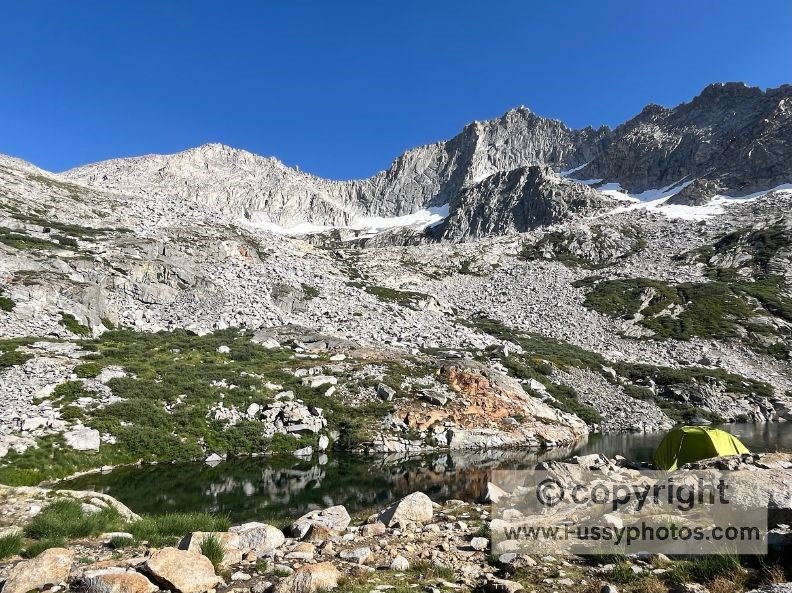
Our campsite was shaded when we woke early to gentle birdsong.
The trail was still shaded as we hiked to Precipice Lake.
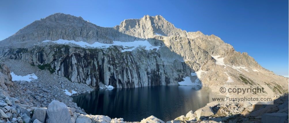
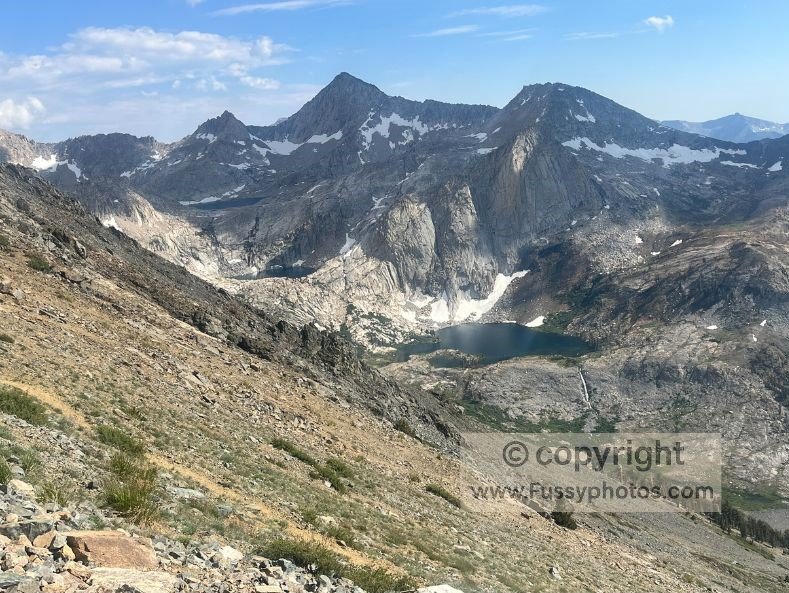
Precipice Lake: Beauty in the Shadows
It was indeed beautiful—a corrie tarn with the cliff face at the back of the lake steep and looking slightly sinister in the shade, black streaks in the rock. The lake was surrounded by snow and boulders, making flat ground for a tent a rare commodity. Yet we saw two or three tents crammed in.
Though beautiful, we both agreed that ours was the better campsite, offering more flat ground, privacy for when nature called, and an arguably equally beautiful—though very different—lake.
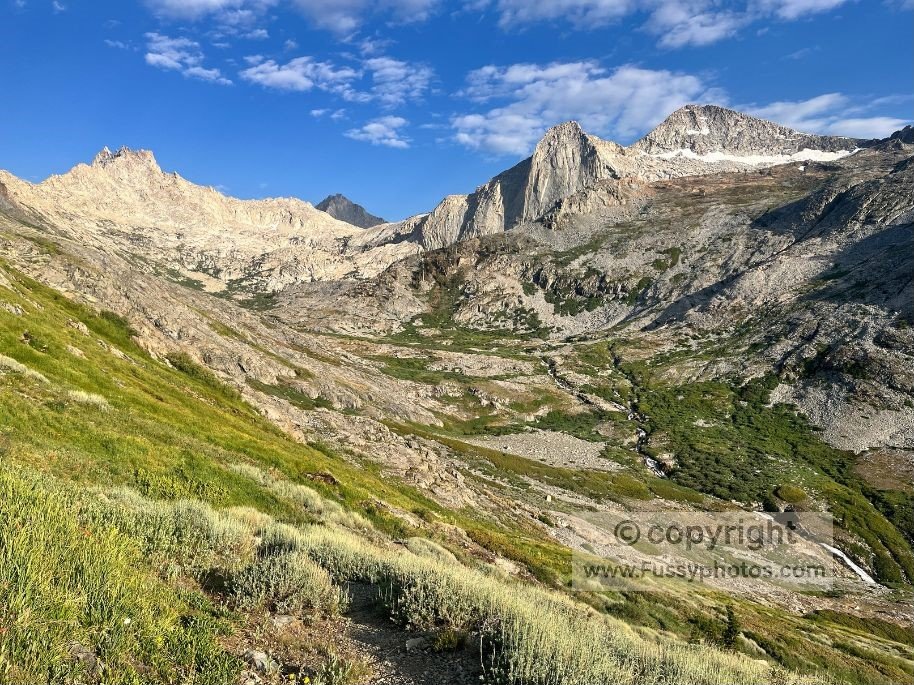
Climbing to Kaweah Gap and Views of Nine Lakes Basin
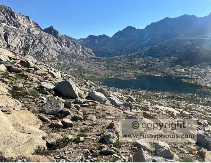
Beyond Precipice Lake, we continued upwards and the landscape shifted—less alpine, more tundra‑like, with hardy vegetation clinging low to the earth. Stark, sweeping, and unmistakably Sierra Nevada.
The sun was still rising as we made it to Kaweah Gap, with gorgeous views northeast toward Nine Lakes Basin. If you’re curious about what makes Sequoia National Park such a remarkable place to explore, my What Is So Special About Sequoia National Park? guide offers a broader look at the park’s landscapes, history, and iconic features.
If we had our time again, this is an area we’d take the time to explore further. In fact, I was disappointed to be going downhill again as we headed south—not just because we were losing all that hard‑earned elevation gain, but also because I love hiking above the treeline, and Big Arroyo was in the trees at the far end of the valley.

Into Big Arroyo on the Hamilton Basin Loop: Mosquito Mayhem
The valley was scattered with erratics and other evidence of glaciation, and as we hiked south, we headed into a classical U‑shaped valley. Not long after dropping beneath the treeline, the mosquitoes were back but the birds sang to us as we descended.
As the trail neared the Big Arroyo Junction—where the High Sierra meets the Big Arroyo Trail—we met some hikers who warned us the mosquitoes were worse further along the way we were heading. In all our hiking, we have never been hit by mosquitoes like those that came our way—they were furious. Three hands wouldn’t have been enough to fend them off!
It got worse when the trail crossed the Big Arroyo River. The water levels were too high and the river far too wide to keep our feet dry, and as we took our shoes off, we got smashed by the little critters. They were so bad and so relentless, we didn’t slow beyond a relentless power‑walk, moving continuously for two hours, not even stopping once for a drink, photo, or video.
Little Five Lakes and the Climb Back Above Treeline
Relenting briefly, things only got worse again at the Little Five Lakes as we searched for a lunch spot. By the time we finally found somewhere to sit and relax, we were breathless—having hiked almost non‑stop for six hours and climbed back to over 10,500 feet from a low of around 9,000.
After a long rest, recharged with food and drink, our moods lifted. We pressed on past the remaining Five Little Lakes, the trail once again carrying us above the treeline. Underfoot, it crunched with each step, while the wind picked up and whistled around our ears as we climbed toward the pass. I hadn’t expected this stretch of the trail to be so beautiful. If this section has you thinking about planning your own trip, my Backpack the Hamilton Basin Loop: Route Guide breaks down start points, itinerary options, Mineral King add‑ons, campgrounds, and permit essentials.
Black Rock Pass: A Slow‑Motion Battle
Near the summit, the climb turned into a slow‑motion battle—just a handful of steps, then pause, gasping, legs trembling, repeat. The air thinned, the trail steepened, and each stride felt like a small victory. But with the pass looming just ahead, the promise of the view pulled us upward, one breathless push at a time.
The pass topped out at 11,600 feet and suddenly the wind hit us, blowing over the brow of the pass from Cliff Creek thousands of feet below. Looking back, we could see not only four of the five Little Lakes but now, beyond the 11,000‑foot peaks below, we could make out some of the Big Five Lakes and, to the left, Chagoopa Plateau—a flat stretch of the High Sierra Trail between Big Arroyo and Kern Valley.
Views Toward Sawtooth Mountain and Spring Lake
As we looked west, we had excellent views of Sawtooth Mountain, Columbine Lake, Cyclamen Lake, and Spring Lake. I wished there was a trail that would take us in a straight line there—all three lakes looking like majestic corrie lakes, each surrounded on three sides by vertical rock faces.
Spring Lake was less than a mile in a straight line from us, yet to get there on the marked trails following the shortest route, it was 13 miles. No doubt keen to conserve the area, there is no trail from Black Rock Pass despite the proximity. I asked a ranger why at the end of our hike, but I received no answer—the ranger was unfamiliar with the lake.
Maybe other hikers would follow their instincts and make the trek there regardless, but we were determined to stick to the campgrounds listed on our permits. So, with some reluctance, we began our descent from the pass, watching each lake disappear from sight one by one as we dropped beneath them.
Descent into Cliff Creek
Black Rock Pass—particularly the Cliff Creek side—remains one of my favorite areas of the Sierra Nevada, and I left with the gut feeling that I’d have to hike the Mineral King area another time.
The descent from Black Rock Pass was bliss—waterfalls tumbling on both sides, their sound echoing through the valley. We dropped 4,100 feet over the final 5.5 miles to camp, each step a mix of wonder and weariness. The scree and loose pebbles punished our feet, blisters blooming with every downhill grind, slowing our pace as the sun set.
The valley, lit in a golden tone, seemed to go on forever, and perhaps it would have been sensible to stop an hour early at Pinto Lake. But we didn’t want to end the day behind again, so we soldiered on.
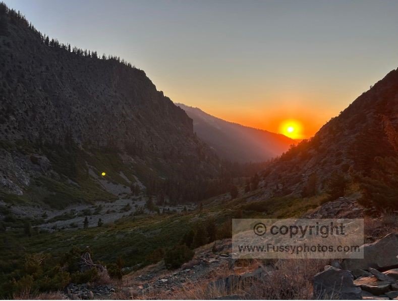
With two miles to go and darkness coming, even a brisk power‑walk didn’t prevent a final 15 minutes hiking through the forest in darkness, torches lighting the way. Lacking signage, we would’ve walked past Cliff Creek campsite had my GPS not indicated its presence to our left.
Like a scene from The Blair Witch Project, we tentatively descended the slope and, 13.5 hours after leaving our camp at Nine Lakes Basin, found a flat open area. We erected the tent in the pitch black, glad to have our headlamps with us.
Watch Part 3 of Our Hamilton Basin Loop Loop: Hamilton Basin – Cliff Creek Campground

Backpack the Hamilton Basin Loop Loop — Part 3 FAQs
Is camping allowed in Hamilton Basin?
Yes, dispersed backcountry camping is allowed, but sites are limited and you must follow standard wilderness regulations.
How difficult is the hike to Precipice Lake?
The climb from Hamilton Lake is steep and exposed in places, but well‑maintained and achievable for fit hikers.
Can you camp at Precipice Lake?
Yes, but flat ground is extremely limited and sites fill quickly. We think the unnamed lake directly below is a better place to camp.
Why is Precipice Lake so famous?
Its sheer black‑streaked cliffs, turquoise water, and Ansel Adams legacy make it one of the most iconic alpine lakes in the Sierra.
Are mosquitoes bad in Big Arroyo?
Yes — early and mid‑summer can bring intense mosquito swarms, especially near water crossings.
Is there camping in Big Arroyo?
Yes, there are several dispersed sites near the junction with the Big Arroyo Trail.
How do you reach the Five Little Lakes?
They’re accessed via the Big Arroyo Trail, typically on the approach to Black Rock Pass.
How hard is the climb up Black Rock Pass?
It’s one of the toughest climbs in Sequoia NP — steep (but maintained), high‑altitude, and exposed.
What is the elevation of Black Rock Pass?
The pass sits at roughly 11,600 feet.
Are the views from Black Rock Pass worth it?
Absolutely — you can see the Little Five Lakes, Big Five Lakes, Sawtooth Mountain, and the Mineral King high country.
Where is Cliff Creek campground located?
It sits below Black Rock Pass on the western side, near the junction with the Timber Gap and Pinto Lake trails.
Is Cliff Creek a good place to camp?
Yes — it’s shaded, near water, and a logical stop after descending from Black Rock Pass.
Do you need a permit for the Hamilton Basin Loop?
Yes. All overnight trips in Sequoia National Park require a wilderness permit, including the full Hamilton Basin Loop and any variations through Hamilton Basin, Big Arroyo, or Black Rock Pass. If you’re planning your own trip, my guide to High Sierra Trail permits, loop hikes, and alternatives explains how to book permits and outlines two excellent loop options, including the Hamilton Basin Loop.
Where do you get permits for the Hamilton Basin Loop?
Permits are issued through Recreation.gov under Sequoia & Kings Canyon National Parks. You select your trailhead, group size, and entry date during the reservation process.
How early do Hamilton Basin Loop permits sell out?
Popular trailheads—especially Crescent Meadow—often sell out within minutes of the reservation window opening. Less common entry points may remain available longer.
Are walk‑up permits available?
A percentage of permits are released as next‑day walk‑ups, but availability varies and demand is high during peak season.
Are bear canisters required on the Hamilton Basin Loop?
Yes. Bear‑resistant food storage is mandatory throughout Sequoia National Park’s wilderness. These can be rented from Lodgepole Visitor Center if you require.