A coastal route packed with puffins, gannets, seals and some of the most dramatic chalk coast in the UK.
Why Walk Bempton Cliffs?
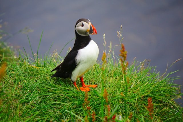
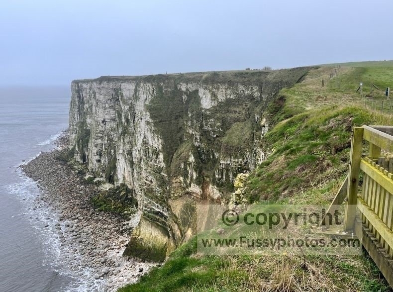
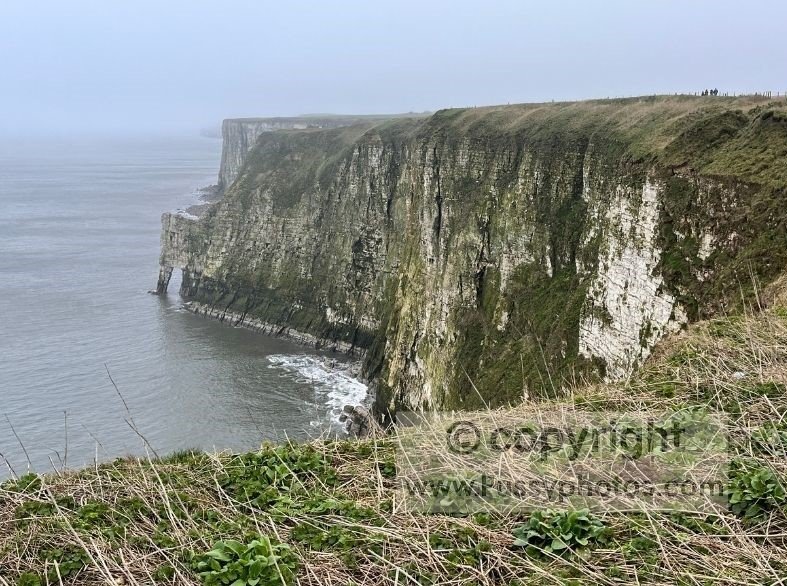
Bempton Cliffs are famous for hosting over half a million seabirds between March and August, making them one of the UK’s best wildlife spectacles. The 100‑metre‑high chalk cliffs are home to puffins, gannets, kittiwakes and guillemots, and the RSPB viewpoints offer some of the most dramatic coastal scenery in Yorkshire.
Even if you’re not a birdwatcher, this is still a superb, relatively flat coastal walk around Flamborough Head, taking in steep cliffs, small bays, Flamborough Lighthouse and wide wave‑cut platforms.
Where to Start the Walk
There are several easy starting points:
- RSPB Bempton Cliffs – ideal for a shorter walk focused on the viewpoints
- North Landing – good facilities and access to the beach
- Flamborough Lighthouse – parking, café and toilets
- Flamborough village – best for a full headland loop
For this full circular route, we began in Flamborough village, heading south to meet the coast before walking anticlockwise around the headland.
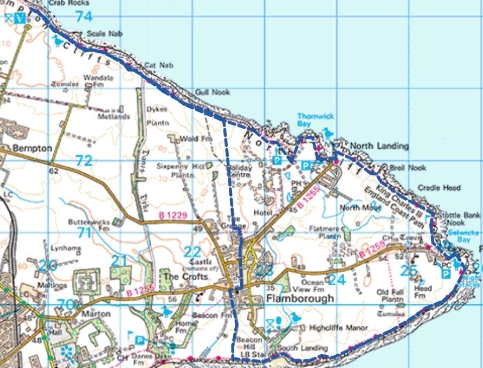
Flamborough to South Landing
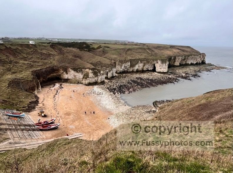
It’s a short walk from the village to the cliffs. Turning east, the trail stays high above the sea before dropping via steps into Flamborough South Landing, a sheltered sandy bay with the Flamborough Lifeboat Station.
After exploring the beach, the path climbs back up a short set of steps and continues along the contours towards Flamborough Lighthouse.
High Stacks and Flamborough Lighthouse
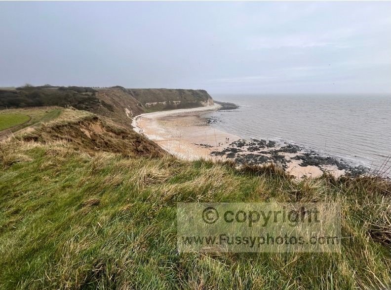
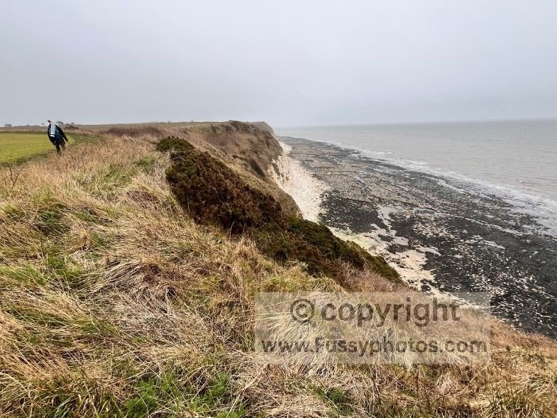
Below the cliffs, a huge wave‑cut platform stretches out towards the sea, running almost all the way to High Stacks on the eastern tip of the headland. This is one of the most striking landforms on the walk: a tall chalk arch, two small beaches often filled with seals, and a narrow ridge connecting the stacks to the mainland.
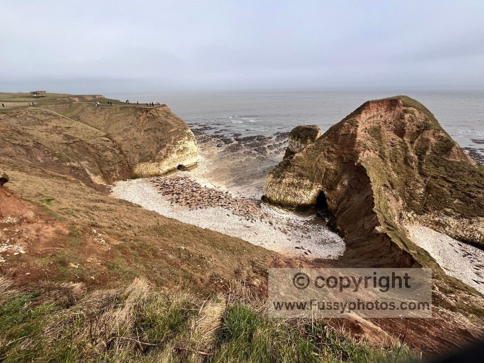
Being close to the lighthouse car park and café, this area can be busy. We were lucky enough to see around 100 seals hauled out on the rocks until a paraglider drifted overhead, prompting a dramatic scramble across the platform as they headed for the water at low tide.
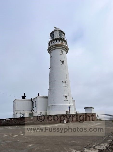
Lunch at Flamborough Lighthouse
There are benches, toilets and a café here, making it a perfect lunch stop with wide views across the headland.
Flamborough Lighthouse to North Landing
From the lighthouse, the trail heads north, squeezed between the golf course and the cliffs. This is a particularly scenic stretch with several excellent viewpoints.
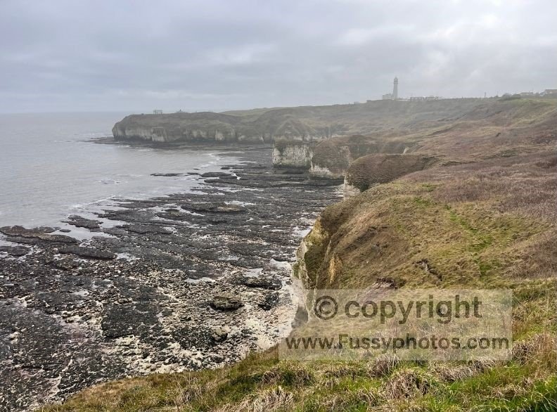
The coastline here is part of Europe’s fastest‑eroding shoreline, though the chalk headland itself is more resilient. You’ll notice sections where the path has been moved inland for safety.
Your next major stop is North Landing, one of the largest bays on the walk. A steep path leads down to the beach, where you can explore caves, stacks and rock formations at low tide.
North Landing to Bempton Cliffs
Beyond North Landing, the cliffs rise sharply and beach access becomes limited. The coastline straightens, offering fewer views down to the water, but the reward comes at the RSPB Bempton Cliffs viewpoints.
Lookouts such as Staple Newk, New Roll-up, Mosey Downgate and Scale Nab provide superb views of nesting seabirds in spring and summer. This is the best place on the walk to see puffins, gannets and kittiwakes up close.
Watch the Bempton Cliffs Circular Walk on the King Charles III Coastal Path

Returning to Flamborough
From Bempton Cliffs you have two options:
- head inland towards Bempton village and follow roads and footpaths back to Flamborough (the longer option), or
- retrace your steps along the clifftop for a couple of miles before turning south on a public footpath.
The inland option via Bempton village is actually the longer of the two, and involves a fair amount of road walking. We opted instead to retrace our steps for a couple of miles along the clifftop path before turning south on a public footpath that skirts the edge of a large holiday park.
We chose the latter, a footpath past a large holiday park, where the sudden shift from gannets to caravans was enough to make us question whether the sea air had gone to our heads.
FAQs for Bempton Cliffs & Flamborough Head
Can you do a circular walk from Bempton Cliffs?
Yes — you can link Bempton Cliffs with North Landing, Flamborough Lighthouse and Flamborough village to create a full circular route around the headland.
Where can I start a Bempton Cliffs walk?
You can start a Bempton Cliffs walk from the RSPB car park, Flamborough Lighthouse, North Landing or Flamborough village, depending on how long a route you want.
Is parking available at Bempton Cliffs?
Yes — the RSPB Bempton Cliffs car park is the closest option, with additional parking at Flamborough Lighthouse, North Landing and Flamborough village.
How long are circular walks from Flamborough to Bempton Cliffs?
Most circular walks linking Flamborough and Bempton Cliffs are around 10–13 miles, depending on your start point and return route.
When can you see puffins at Bempton Cliffs?
Puffins are usually at Bempton Cliffs from late April to early August, with the best viewing in June and early July.
Can you see seals on the Flamborough and Bempton Cliffs walk?
Yes — seals are often seen around High Stacks and the wave‑cut platforms near Flamborough Lighthouse.
Is a Bempton Cliffs walk difficult?
It depends how long you want it to be. If you start at Bempton Cliffs and just visit the RSPB viewpoints, it’s an easy, mostly flat walk. If you begin in Flamborough and complete the full circular route around the headland to Bempton Cliffs and back, it’s a longer, more demanding walk with a few short, steeper sections.
Is Bempton Cliffs part of the King Charles III Coastal Path?
Yes — large sections of the walk form part of the King Charles III Coastal Path along the Yorkshire coast.
Explore More Walks in East Yorkshire
If you’d like to explore inland after walking the Flamborough and Bempton coastline, the Yorkshire Wolds Way begins just south of here at the Humber Bridge and finishes at Filey, south of Flamborough.
My Best Yorkshire Wolds Walks collection features the finest routes across the Wolds, including sections of the Yorkshire Wolds Way, which finishes nearby at Filey.