Zion National Park: First Impressions & Why This Guide Exists
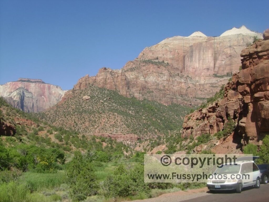
My first experience of Zion National Park was shaped by the scale of the place — those steep red‑rock walls rising straight from the canyon floor, the heat settling in early, and the feeling of being drawn deeper into Zion Canyon with every bend in the road. I tried Angels Landing on that trip and loved the switchbacks up to Scout Lookout, but the final ridge was far narrower and more exposed than I expected. I followed the chains for a while before vertigo made the decision for me. The Narrows offered the perfect contrast: cool water, waist‑deep sections, and tall shaded walls that made the heat bearable.
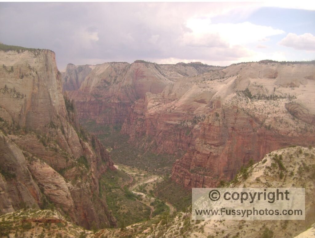
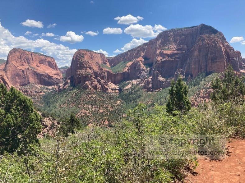
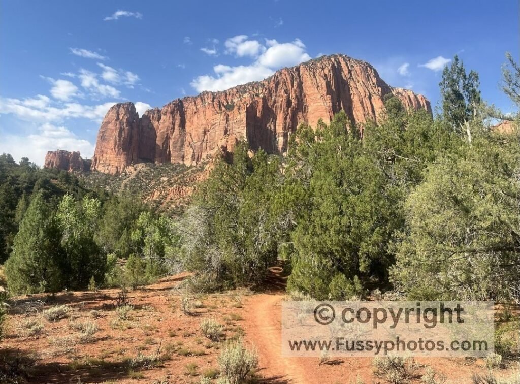
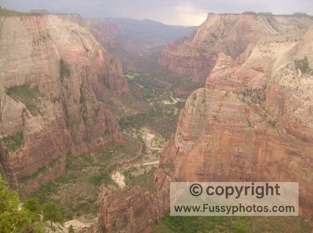
On a later visit I hiked Observation Point via the old East Rim route, now closed by a rockfall. I liked how the trail briefly detoured into Hidden Canyon before climbing into a quieter part of the park, eventually opening out to a viewpoint over Zion Canyon with Angels Landing far below. Another trip took me to Kolob Canyons, a smaller and quieter area with fewer trails but a welcome break from the main‑canyon crowds.
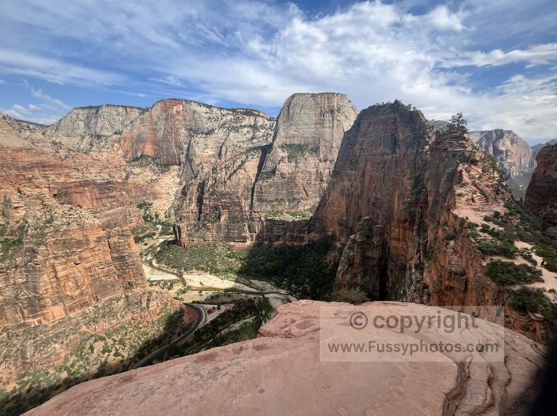
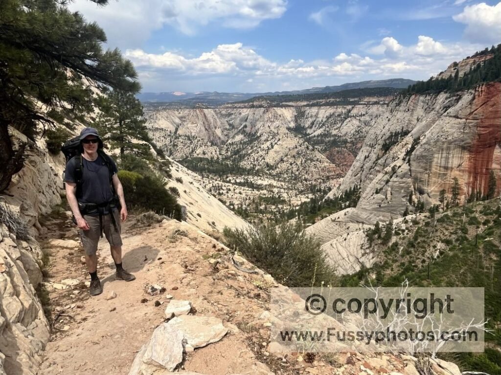
Most recently, I walked part of the Zion Traverse, which turned out to be more varied than I expected — long stretches of solitude and a mix of viewpoints that genuinely surprised me. The miles leading up to Scout Lookout were a highlight in themselves: spectacular scenery and, unusually for Zion National Park, we had the trail almost entirely to ourselves. Some viewpoints along the West Rim and the connector trail were every bit as impressive as anything in Zion Canyon, just seen from farther away rather than being surrounded by the cliffs themselves. Finishing back in the main canyon at Angels Landing and The Grotto made the contrast even sharper.
Those experiences shaped how I think about Zion National Park. The famous hikes are famous for a reason, but there’s far more to the park than the main canyon. This guide brings both sides together — the classics and the quieter alternatives — so you can choose the version of Zion that suits you.
Zion National Park is divided into three main areas: Zion Canyon (the famous shuttle‑served corridor), Kolob Canyons (a quieter northwest district), and the East Side (slickrock, viewpoints, and access to Observation Point).
For a full comparison of the three areas — including which one is best for your trip — see my guide to Zion Canyon vs Kolob Canyons vs the East Side.
Best Zion Hikes — Iconic Routes & Quieter Alternatives
Zion has a handful of famous trails that draw most of the attention, and they’re popular for good reason. But there are also quieter options that offer great scenery without the same crowds or exposure. Here’s a look at both sides of the park’s hiking scene.
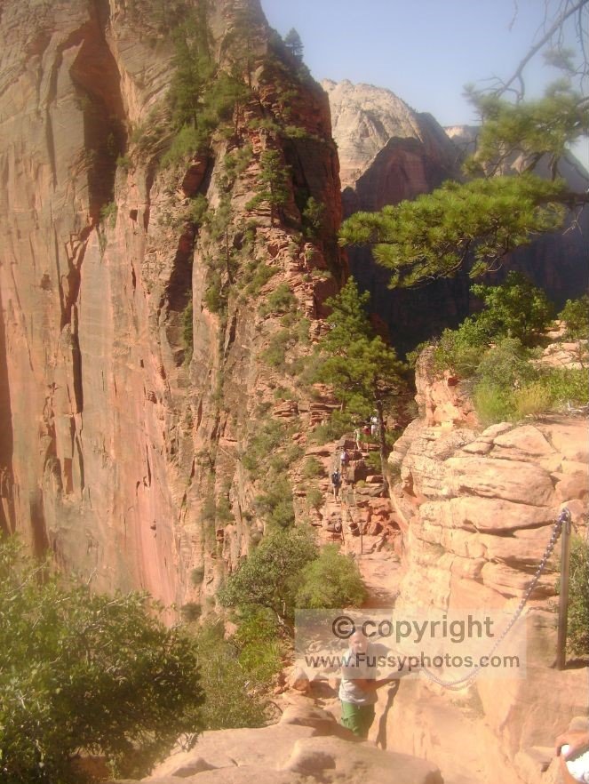
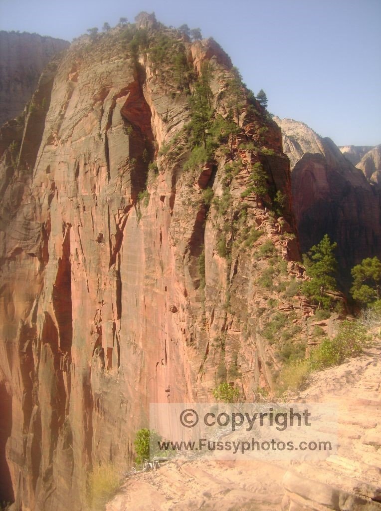
Angels Landing (via West Rim Trail to Scout Lookout)
The climb to Scout Lookout begins from The Grotto shuttle stop and is steep but manageable, with excellent views into Zion Canyon. Beyond this point, the famous chain section becomes far narrower and more exposed than many people expect.
The ridge has significant drop‑offs on both sides for long stretches, and the footing requires steady concentration. The permit system now limits numbers, but even if you stop at Scout Lookout, the hike is still worthwhile for the scenery and the sense of being high above the canyon floor.
If you want to explore more of this corridor beyond Scout Lookout, the West Rim Trail makes an exceptional standalone hike. My West Rim Trail: Top‑Down vs Bottom‑Up guide explains the full route, campsites, and logistics.
The Narrows (Bottom‑Up)
A classic Zion experience: cool water, tall walls, and a welcome break from the heat. The hike begins from the Temple of Sinawava shuttle stop and follows the river upstream as an out‑and‑back, with day hikers choosing their own turnaround point before heading back. Expect to walk in the river for most of the day, with sections that can reach knee‑ to waist‑deep depending on recent conditions.
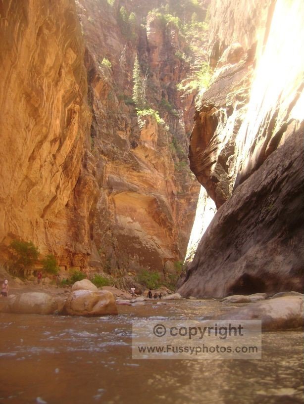
The full length of the canyon is a two‑day backcountry trip (usually done top‑to‑bottom), so day walkers won’t reach the far end. Crowds thin out the farther you go, but the first mile can feel busy. Water levels and conditions vary, so it’s worth checking the forecast and flow rate before setting out.
Observation Point (via East Mesa/East Rim Trailhead)
The old route from Zion Canyon is closed by a rockfall, but the viewpoint is still accessible from the East Mesa/East Rim Trailhead — see my Observation Point guide for details.. Most visitors reach it via the East Mesa Trail, a moderate walk through open forest and pockets of slickrock that offers occasional glimpses into nearby side canyons before meeting the East Rim Trail for the short final stretch to the overlook.
There is also a far more demanding alternative: approaching from the East Rim Trail. This is a long backcountry route that climbs onto the plateau, winds through stands of pine, and eventually drops into Echo Canyon before working its way up to Observation Point. It’s a rewarding option for experienced backpackers, but far more strenuous — and much longer — than the East Mesa approach.
Canyon Overlook Trail
A short, popular walk near the east entrance with a great payoff. It’s one of the easiest ways to get a high‑level view without a long climb, though parking can be limited.
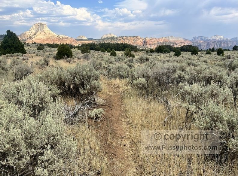
La Verkin Creek Trail (Kolob Canyons)
A trail with long views and access to around a dozen backcountry campsites. The trail also leads to Kolob Arch, an impressively large sandstone span tucked deep in a side canyon and often counted among the biggest natural arches in the world. La Verkin Creek works as a long day hike, but the heat and exposure often make it more enjoyable as an overnight. It also forms the western start of the Zion Traverse (see my Zion Traverse: Kolob Canyon to Angels Landing guide).
East Side Slickrock Routes
Not formal trails, but a collection of short walks and route‑finding scrambles off the Zion–Mount Carmel Highway.
Understanding the Zion Shuttle System
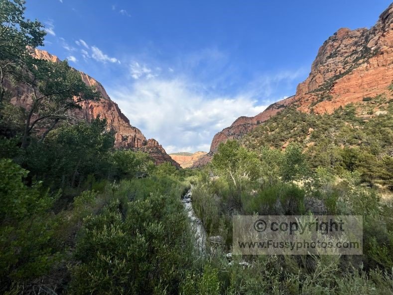
For much of the year, the main section of Zion Canyon is accessible only by shuttle. It’s a simple system once you know how it works, and it’s the easiest way to reach many of the park’s most popular trailheads. Shuttles run frequently throughout the day, stopping at key points such as The Grotto (for Angels Landing), Temple of Sinawava (for The Narrows), and the trailheads for the Emerald Pools and West Rim.
Parking at the visitor center can fill early, especially in peak season, so it’s worth arriving with a little time to spare. An alternative is to park in Springdale, where a separate town shuttle operates seasonally and drops you at the park entrance near the visitor center and South Campground. Once you’re on board the main park shuttle, the ride takes the pressure off driving and gives you a great first look at the canyon’s scale.
If you prefer to walk for part of your return, the Pa’rus Trail follows the Virgin River from Canyon Junction back toward the visitor center and South Campground. It’s a gentle, scenic path and a surprisingly peaceful way to end the day when the shuttles are at their busiest.
If you’re heading to the East Side or Kolob Canyons, those areas are reached by car rather than shuttle.
When to Visit Zion
Zion is open year‑round, but the experience changes dramatically with the seasons. Spring and autumn are the most comfortable times to visit, with warm days, cooler nights, and good conditions for most hikes. Summer brings long daylight hours and reliable access to high‑country trails, but it’s also the hottest and busiest period in the park. Winter is much quieter, and the low‑angle light can be beautiful, though snow and ice may linger on higher routes.
The Zion Canyon Shuttle typically runs through the main visitor season, which shapes how you move around the canyon. Trails like Angels Landing, The Narrows, and the Emerald Pools are accessible whenever the shuttles operate. Your ideal time to visit depends on what you want from the park — cooler hiking weather, quieter viewpoints, or the full energy of Zion in summer.
Heat, Weather & Seasonal Conditions
Zion’s weather shapes the experience as much as the scenery. Summer heat is the biggest factor for most visitors, with temperatures in the main canyon often climbing well above 100°F. Early starts, plenty of water, and choosing shaded or higher‑elevation routes can make a huge difference.
In spring and autumn, temperatures are far more comfortable, though storms can move through quickly and bring short periods of rain or wind. These seasons are excellent for longer hikes, especially those with more exposure or elevation gain.
Winter is much quieter, and the low sun brings beautiful light into the canyon. Snow and ice can linger on higher trails, especially on north‑facing slopes, so traction can be helpful for certain routes. Lower‑elevation paths often remain accessible, making winter a surprisingly good time for peaceful walks.
Water levels in The Narrows change with snowmelt and recent weather, and flash‑flood potential is something to be aware of during stormy periods. Conditions are usually posted at the visitor center and shuttle stops, making it easy to check before you set out.
Choosing the Right Zion Hike for You
Zion has a wide range of trails, and the best choice depends on what you want from the park — big views, quieter corners, a challenge, or something gentle after a long day of exploring. The famous routes like Angels Landing, The Narrows, and Observation Point offer unforgettable scenery, but they also come with crowds, exposure, or specific conditions to consider.
Your comfort with heat, exposure, and elevation gain plays a big role in choosing the right hike. Early starts help with summer temperatures, and shaded or higher‑elevation routes can feel more manageable on hot days.
Practical Planning Tips
A little preparation goes a long way in Zion, especially during the busier months. The shuttle system shapes how you move through the canyon, so it helps to have a rough plan before you arrive — which trail you want to start with, where you’ll pick up the shuttle, and whether you’ll be returning on foot via the Pa’rus Trail or riding back to the visitor center.
If you’re hiking one of the iconic routes, early starts make a big difference. Temperatures are cooler, the light is better, and you’ll reach the viewpoints before the busiest part of the day. For other trails, timing is more flexible, but it’s still worth checking conditions and giving yourself enough daylight for the return.
Parking can fill quickly at the visitor center, so many people choose to stay in Springdale and use the seasonal town shuttle to reach the park entrance. It’s a simple way to avoid the morning rush and start your day without stress.
Where to Stay for Visiting Zion
Zion Canyon
Most visitors base themselves in Springdale, the small town right outside the park’s South Entrance. It’s the most convenient place to stay if you want easy access to the Zion Canyon Shuttle, restaurants, and trailheads in Zion Canyon. The seasonal Springdale Town Shuttle stops throughout Springdale and drops you at the park entrance, which makes mornings far simpler than trying to secure a parking spot at the Visitor Center. Because of the location, accommodation here is noticeably more expensive than in the surrounding towns, but the convenience is hard to beat if you want to be close to the canyon.
Inside the park, South Campground and Watchman Campground offer the closest access to the canyon, with the Pa’rus Trail running right past them. They book up quickly in peak season, and they can be very warm in summer, but the location is ideal if you prefer to walk or bike into the park rather than rely on the shuttle.
East Side (Zion–Mount Carmel Highway)
If you’re exploring the East Side or heading toward Observation Point via the East Mesa Trail, staying near the Zion–Mount Carmel Highway can save a lot of driving. There are a handful of private campgrounds, small lodges, and resort‑style stays scattered along this stretch outside the park, but they’re dispersed rather than forming a single town, so it’s worth checking locations carefully when planning your trip.
Kolob Canyons
For trips that include Kolob Canyons or the Zion Traverse, accommodations in La Verkin, Toquerville, or Cedar City can be more practical. These towns sit farther from the main canyon, so prices are often lower than in Springdale, making them a good option for budget‑minded travelers while still keeping you well under an hour’s drive from both Kolob Canyons and Zion Canyon.
FAQs for Zion National Park
When is the best time to visit Zion?
Spring and autumn offer the most comfortable temperatures and great hiking conditions. Summer brings long, hot days, especially on the canyon floor, while winter is quieter with occasional snow or ice on higher trails.
Is Zion too hot to visit in summer?
It can be very hot, especially in the main canyon where temperatures often exceed 100°F. Early starts, shaded routes, and higher‑elevation trails help a lot. Many visitors pair one big morning hike with a quieter afternoon walk or scenic drive.
Do I need a shuttle ticket to visit Zion?
No — the Zion Canyon Shuttle is free and runs seasonally. You only need a permit if you’re hiking Angels Landing. During shuttle season, private vehicles aren’t allowed in Zion Canyon, so plan your day around the shuttle schedule.
Do I need a permit to hike Angels Landing?
Yes. Since 2022, a permit has been required for the chain section from Scout Lookout to Angels Landing. Permits for Angels Landing are also included when you obtain a Zion Traverse hiking permit. For more details on this hike, see my page How Best to Unlock the Zion Traverse to Angels Landing.
Do I need a permit to hike The Narrows?
Bottom‑Up (from Temple of Sinawava): No permit required, but check water levels and flash flood warnings.
Top‑Down (from Chamberlain’s Ranch): Permit required
Is The Narrows always open?
No. The Narrows can close due to high water, snowmelt, or elevated flash‑flood risk. Conditions are posted daily at the visitor center and shuttle stops, so it’s easy to check before you set out.
Is Zion good for beginners?
Absolutely. While the big-name trails get the attention, Zion has plenty of easier options like the Pa’rus Trail, Riverside Walk, and short East Side slickrock routes. Choosing the right hike for your comfort level makes a huge difference.
How does the shuttle system work?
From March through late November, private vehicles are restricted in Zion’s main canyon. Free shuttles run frequently between trailheads, though they can become crowded. Check the NPS website for the schedule of the first and last shuttles.
Are dogs allowed in Zion National Park?
Pets are welcome in Zion’s campgrounds, along park roads, and on the paved Pa’rus Trail. They aren’t permitted on other trails or in wilderness areas.
How long do I need to see Zion?
Two to three days gives you time for one iconic hike, a quieter alternative, and some exploring on the East Side or Kolob Canyons. Even a single day works well if you start early and focus on one area.
Best Zion National Park Trails — Plan, Discover & Hike
Click on a link below to read about my favourite hikes in Zion.
How Zion National Park Fits into a Southwest Road Trip
Zion National Park is a natural hub for exploring the American Southwest, with easy access to both iconic Utah parks and neighboring states. If you’re looking for a world‑class day hike to pair with the Traverse, my Observation Point guide covers one of Zion’s most iconic viewpoints.
- Bryce Canyon National Park is the closest of Utah’s “Big 5,” located just 2 hours northeast. From there, the natural route continues to Capitol Reef National Park, followed by either Arches National Park or Canyonlands National Park, both around 4.5 hours northeast of Zion. If you’re heading toward Capitol Reef, my 2-day backcountry loop guide explores one of Utah’s most underrated wilderness routes — a perfect follow‑up to the Zion Traverse.
- Heading southwest, Las Vegas is just over 2 hours away, making it a convenient entry or exit point for your trip.
- The Grand Canyon is about 3 hours away—though reaching the South Rim takes longer depending on your route. If you’re pairing Zion with the Grand Canyon, my Rim‑to‑River‑to‑Rim guide covers one of the most spectacular big‑day or overnight hikes in the Southwest.
- Heading northwest, Great Basin National Park in Nevada is approximately 2.5 hours away, offering a quieter contrast to Zion’s dramatic cliffs.
Whether you’re chasing red rock vistas or crafting a full Utah Big 5 itinerary, Zion slots perfectly into a multi-day adventure across the Southwest