The Yorkshire Dales section of the Pennine Way was one of the highlights of my own Pennine Way walk. In quick succession, the trail takes you from Malham Cove, Malham Tarn (with optional detour to Gordale Scar), Pen y Ghent, past Ribblesdale Viaduct, past Wensleydale Creamery, beside winding rivers and drystone walls. This beginner weekend walk gives you a concentrated taste of all of that — big scenery, classic Pennine Way features, and a clear, confidence‑building route.
For the full trip report covering this four‑day stretch — including Malham, Horton‑in‑Ribblesdale, Hardraw and Middleton‑in‑Teesdale — see my Pennine Way Days 6–9 write-up.
What Makes This Yorkshire Dales Section of the Pennine Way So Beginner‑Friendly
This stretch of the Pennine Way is one of the most approachable sections of the entire trail. It combines classic Yorkshire Dales scenery with practical advantages that make a first multi‑day walk far less intimidating:
- Accessible: train stations at both ends make travel simple.
- Not too remote: you’re never far from a village, road or farm.
- Clear paths: the Pennine Way is well waymarked throughout this section.
- Villages at sensible intervals: Malham and Horton‑in‑Ribblesdale both offer food, accommodation and transport.
- Forgiving terrain: compared with the High Pennines, the Dales are gentler underfoot and easier to navigate.
With easy navigation, limited but useful amenities in Malham and Horton‑in‑Ribblesdale, and public transport at both ends, this is an ideal place to try the Pennine Way for the first time — and short enough to fit neatly into a weekend.
If you’d prefer a Peak District version of this idea, my Edale → Crowden → Marsden weekend guide offers a similarly manageable two‑day introduction to the Pennine Way with train stations at both ends.
Two Beginner‑Friendly Pennine Way Itineraries in the Dales
There are two strong ways to structure a two‑day Pennine Way weekend in the Dales. Both give you a safe, scenic introduction to long‑distance walking, with straightforward logistics and no need for a car.
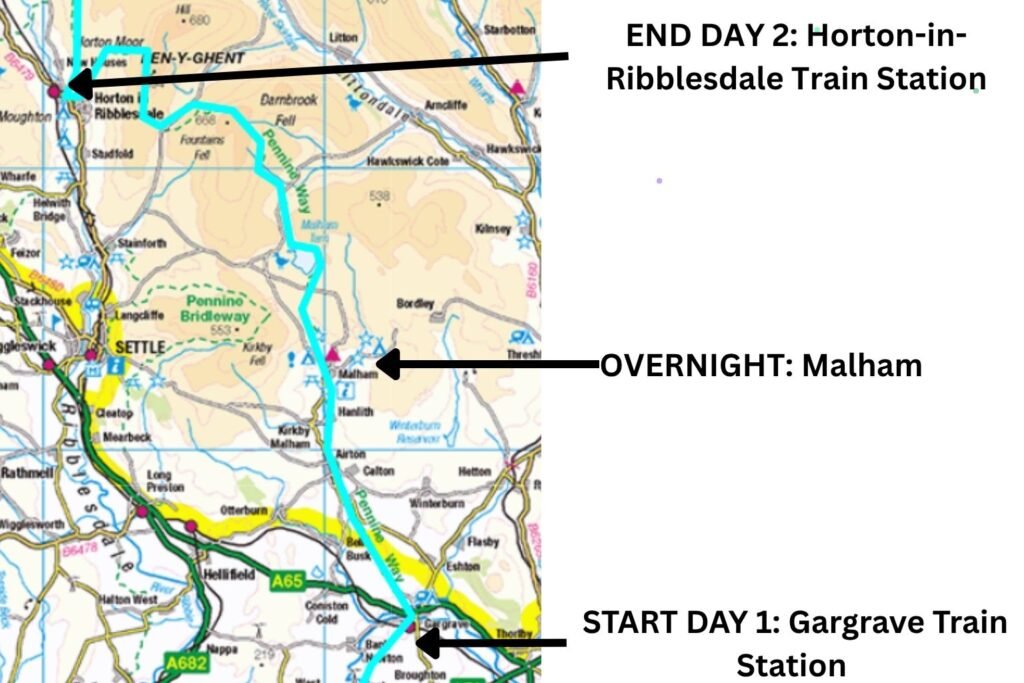
Option 1: Gargrave → Malham → Horton‑in‑Ribblesdale (Recommended)
This is the simplest and most beginner‑friendly version.
Day 1: Gargrave to Malham (6.5 miles)
Take the train to Gargrave, then follow the Pennine Way to Malham. The walking is gentle, the route is clear, and Malham has accommodation, pubs and shops. You can also add the optional detour to Gordale Scar if you want a short extra challenge.
Day 2: Malham to Horton‑in‑Ribblesdale (14.5 miles)
A classic Pennine Way day featuring:
- Malham Cove
- Limestone pavement
- Malham Tarn
- Pen‑y‑ghent
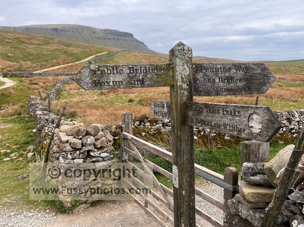
At Horton‑in‑Ribblesdale, a second train station makes it easy to return home at the end of your weekend.
OS Map Extract for Option 1: Gargrave → Malham → Horton‑in‑Ribblesdale
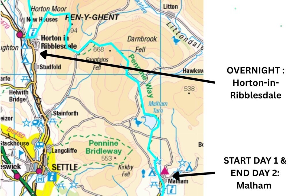
Option 2: Malham → Horton → Malham (Longer Alternative)
This version works if you prefer to start in Malham and don’t mind retracing your steps.
Take the train to Gargrave, then a bus to Malham (services run once or twice a day).
Day 1: Malham to Horton‑in‑Ribblesdale
Walk the Pennine Way north over Malham Cove, Malham Tarn and Pen‑y‑ghent, then spend the night in Horton‑in‑Ribblesdale.
Day 2: Horton‑in‑Ribblesdale back to Malham
Return the same way, giving you a second chance to enjoy the limestone scenery and the Pen‑y‑ghent ridge in reverse.
This option is slightly less convenient due to the bus timings, but it’s a good choice if you want to base yourself in Malham before and after the walk.
OS Map Extract for Option 2: Malham → Horton → Malham
Key Facts
Distance
Option 1 (Recommended)
- Day 1: Gargrave → Malham — 6.5 miles
- Day 2: Malham → Horton‑in‑Ribblesdale — 14.5 miles
- Total: 21 miles
Option 2 (Out‑and‑Back)
- Day 1: Malham → Horton‑in‑Ribblesdale — 14.5 miles
- Day 2: Horton‑in‑Ribblesdale → Malham — 14.5 miles
- Total: 29 miles
Start & Finish
Option 1
- Start: Gargrave (train station)
- Finish: Horton‑in‑Ribblesdale (train station)
Option 2 (Out‑and‑Back)
- Start: Malham (bus from Gargrave)
- Finish: Malham (after returning from Horton)
Difficulty
Moderate — clear paths, one steep climb, manageable distances for beginners
Best Season
Late spring to early autumn (May–September)
Navigation
Straightforward; well‑waymarked throughout
For a full breakdown of waymarks, symbols and what to expect on the trail, see my Pennine Way navigation guide.
OS Map:
OS Explorer OL2 – Yorkshire Dales: Southern & Western Areas (covers Gargrave, Malham, Malham Cove, Malham Tarn and Pen‑y‑ghent)
Terrain
Limestone pavement, moorland tracks, stepped ascent, riverside paths
Accommodation
- Malham: hotels, B&Bs, campsite
- Horton‑in‑Ribblesdale: seasonal B&Bs and campsite
Food & Facilities
- Malham: pubs, cafés, shop
- Horton: café and limited facilities (seasonal)
- None between Malham Tarn and Horton
Public Transport
- Trains to Gargrave and Horton‑in‑Ribblesdale
- Infrequent buses to Malham (Option 2)
Watch the Malham to Horton Weekend Guide (Pennine Way Video)
A clear, route‑focused walkthrough of the Malham, Malham Tarn and Pen y Ghent weekend for walkers new to the Pennine Way.

Pennine Way Weekend Overview: The Route at a Glance
Option 1: Gargrave → Malham
From Gargrave train station, follow the road north into the village centre, where you’ll find cafés and shops popular with walkers. The Pennine Way leaves Gargrave by following the road north for around three‑quarters of a mile before a footpath branches off to the right.
The trail crosses a series of fields and small plantations, with gentle rolling hills rising to roughly 200 metres. After a slightly fiddly couple of miles, the route runs parallel to the main road towards Malham, and navigation becomes straightforward.
Following the River Aire Towards Malham
Views open up as you follow the eastern bank of the River Aire. As the path settles into a clearer line, views open up along the eastern bank of the River Aire. This is a pleasant, easy stretch that leads you steadily towards the limestone scenery ahead. Just east of Kirkby Malham, a short, sharp ascent brings you briefly onto the road before the Pennine Way turns north again. Malham Cove soon comes into view, confirming you’re on the right line.
There is a campsite between Malham and the Cove (booking can be difficult), and several hotels and B&Bs in the village, though prices are not budget‑friendly.
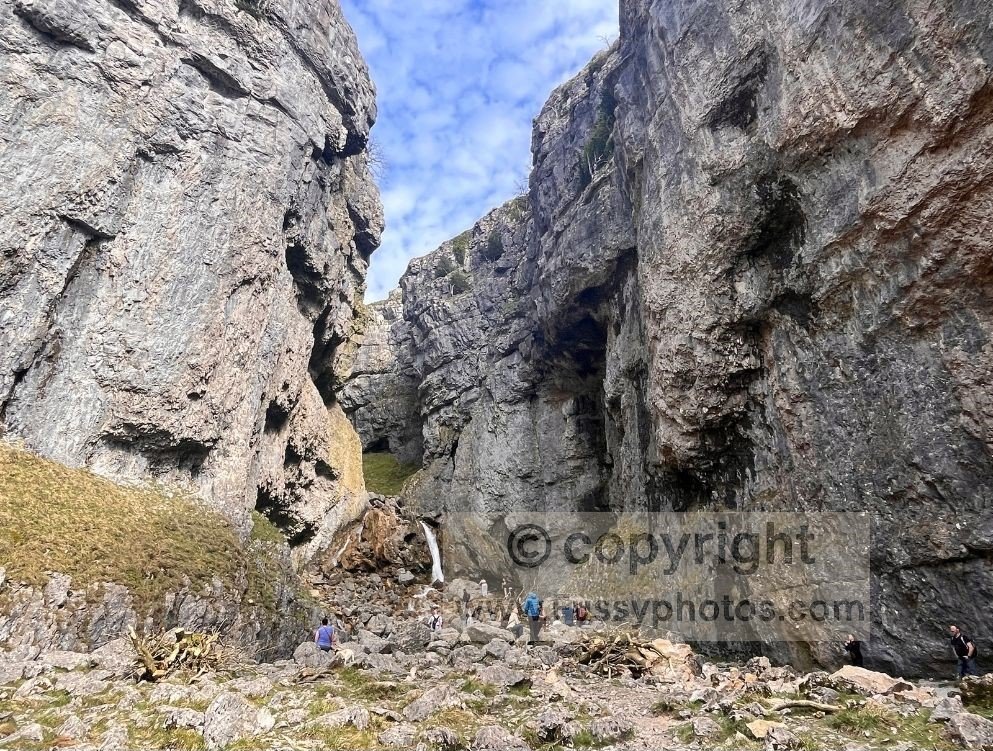
Detouring to Janet’s Foss and Gordale Scar
If you want to visit Gordale Scar, the most direct approach is to follow the road from Malham. Alternatively, you can leave the Pennine Way shortly before reaching the village and follow a footpath to Janet’s Foss and Gordale Scar, returning either the same way or via Gordale Lane. This detour adds some of the most dramatic scenery in the area and is well worth considering if you have the time and energy.
Malham → Horton‑in‑Ribblesdale (Option 1 & 2)
Overview of the Day
After a night in Malham, the Pennine Way heads north along Cove Road before turning right towards Malham Cove. This is the start of one of the most varied and rewarding days on the entire trail.
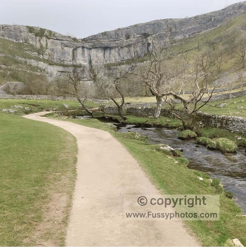
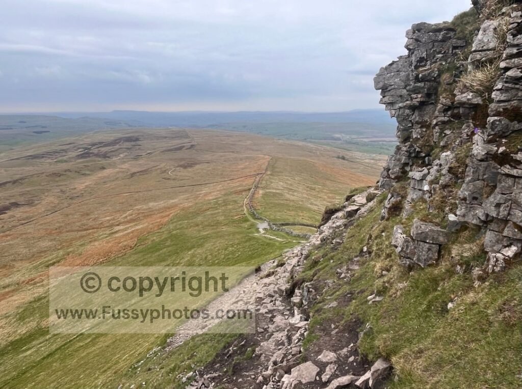
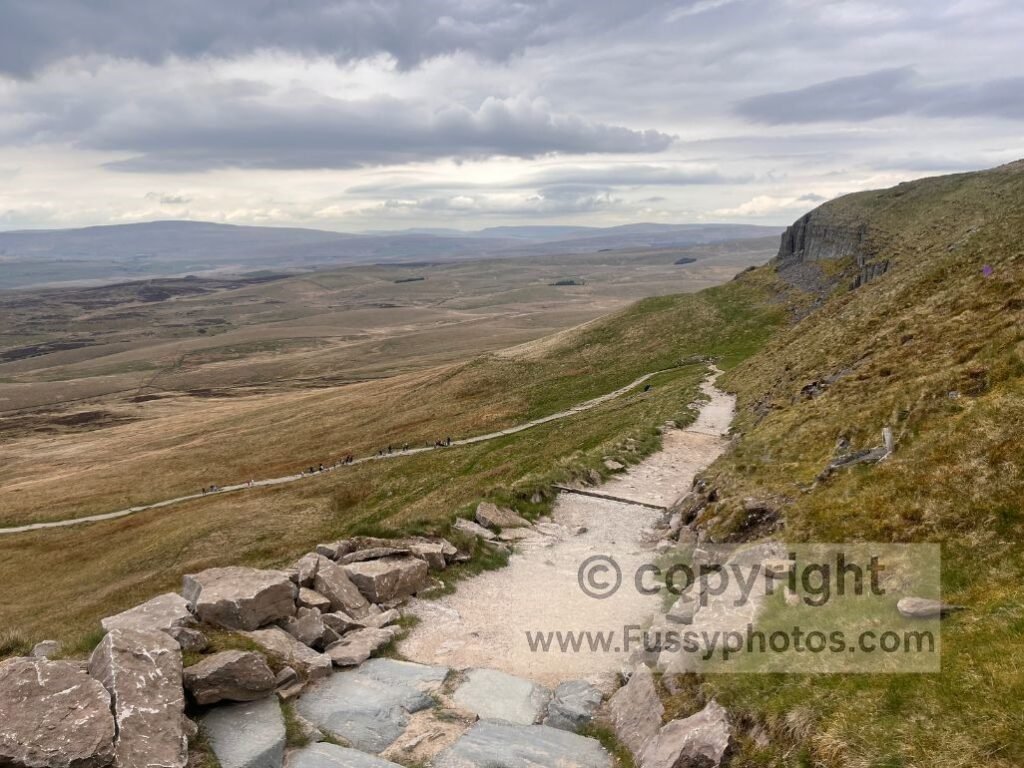
Climbing Malham Cove and Crossing the Limestone Pavement
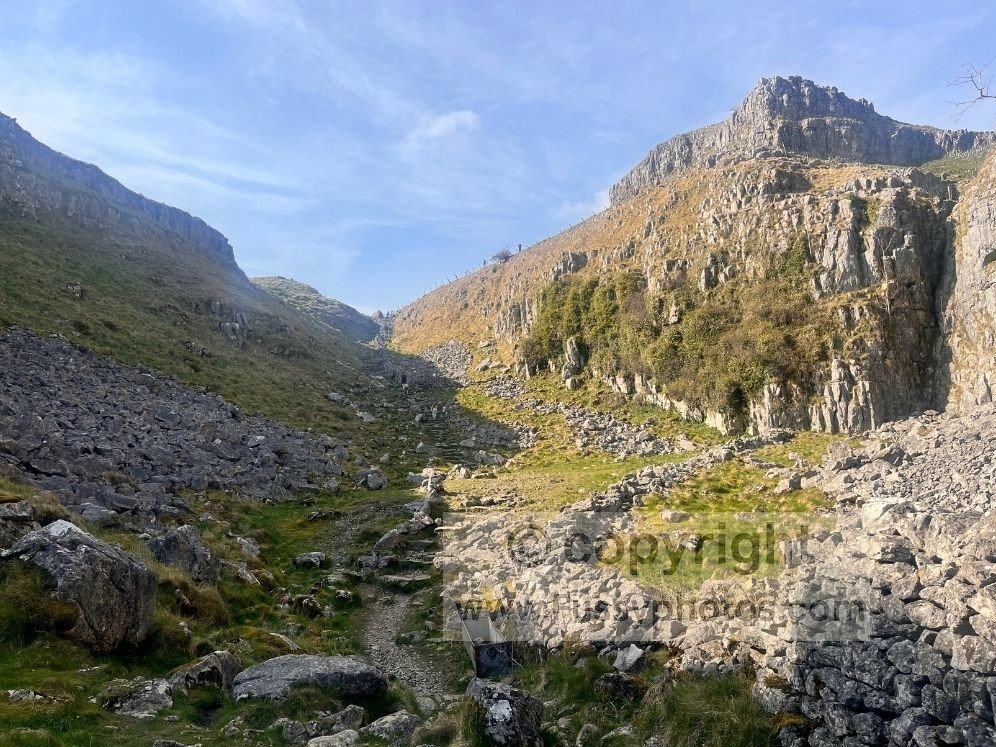
From the base of Malham Cove, steep stone steps lead to the top of the limestone pavement, offering wide views south over the village. The Pennine Way then follows Ing Scar, a dramatic limestone edge that guides you towards Malham Tarn.
For a more detailed look at this landscape, see my circular day walk from Malham to Malham Tarn, Gordale Scar viewpoint, Janet’s Foss and Malham Cove.
Easy Miles Around Malham Tarn
Crowds thin out around Malham Tarn, and the terrain becomes easier. The route follows a well‑marked unpaved road around the glacial tarn — expect cyclists but no cars — before leaving the track beyond the former youth hostel on the north side of the water.
This section offers some of the most relaxed walking of the weekend.
Quiet Moorland Miles Towards Pen‑y‑ghent
The next 4.5 miles, across open moorland towards the base of Pen‑y‑ghent, are the most remote of the weekend. It’s a good introduction to the quieter, more exposed miles found elsewhere on the Pennine Way, without ever feeling committing or difficult to navigate.
Ascending Pen‑y‑ghent and the Descent to Horton
The southern ascent of Pen‑y‑ghent is rocky and steep. In poor weather it can feel challenging — on my own Pennine Way through‑hike, winds were strong enough to knock me off balance — but in good conditions it’s an excellent climb with rewarding views.
A long descent leads into Horton‑in‑Ribblesdale, where there is seasonal accommodation and a campsite (check opening times before travelling).
- If you’re completing Option 1: stay overnight or catch the train home from Horton station.
- If you’re completing Option 2: spend the night in Horton, then retrace your steps back to Malham the following day.
Pen-y-ghent appears in my Top 10 Highlights of the Pennine Way (Ranked) — the combination of the open views and the sweeping descent into Horton is one of the trail’s standout moments.
What you’ll learn on this Pennine Way weekend walk
At 14.5 miles, the Malham to Horton‑in‑Ribblesdale day is long enough to give you a realistic sense of what a typical Pennine Way stage feels like. It’s a useful test of your fitness, pacing and comfort with carrying a pack over varied terrain.
Expect company on the trail as far as Malham Tarn and again on the ascent of Pen‑y‑ghent, but quieter stretches in between offer a welcome sense of solitude. This balance of sociable and peaceful miles makes it an ideal introduction to long‑distance walking, giving you the confidence to judge whether multi‑day routes are something you’d enjoy tackling more often.
If you want to see what comes next on the Pennine Way after this beginner‑friendly weekend, my Pennine Way Days 6–9 trip report covers the full Malham to Middleton‑in‑Teesdale section in detail.
FAQs
Is this section suitable for complete beginners?
Yes. The paths are clear, the navigation is straightforward, and both ends of the route have train stations. The terrain is varied but manageable, making it one of the most accessible introductions to the Pennine Way.
If you’re new to the Pennine Way, you’ll find a clear, beginner‑friendly introduction in my simple guide to starting the trail.
How difficult is the climb up Pen‑y‑ghent?
The southern ascent of Pen‑y‑ghent is short but steep, climbing from roughly 433 metres to 697 metres in just one mile. The path is rocky and requires steady footing, but it’s well‑trodden and easy to follow. In good weather it’s a rewarding climb with wide views across the Dales; in strong winds or poor visibility it can feel more challenging, so checking the forecast before setting out is sensible.
For a shorter standalone option, my Pen y Ghent circular walk covers the summit with a simple route from Horton‑in‑Ribblesdale and a detour to Hull Pot.
Are there shops or cafés on the route?
Yes. Malham has pubs, cafés and accommodation. Horton‑in‑Ribblesdale has seasonal facilities, including a pub and a small shop, though opening times vary. There are no services between Malham Tarn and Horton.
Is navigation difficult?
No. The Pennine Way is well waymarked throughout this section. The route around Malham Cove, Malham Tarn and Pen‑y‑ghent is especially clear. A mapping app or paper map is still recommended.
Do I need special gear for this weekend?
No specialist equipment is required. Sturdy footwear, waterproofs, warm layers and a comfortable daypack are sufficient. If you’re carrying an overnight pack, this weekend is an excellent chance to test how it feels over longer miles.
Can I shorten the route?
Yes. You can finish at Malham after Day 1, or start at Malham and walk only to Pen‑y‑ghent before returning. Public transport makes it easy to adapt the weekend to your fitness and confidence.
Is public transport reliable for this itinerary?
Gargrave and Horton‑in‑Ribblesdale both have train stations. Buses to Malham run infrequently, so check timetables carefully if you’re planning Option 2.
What happens if the weather turns bad?
The route has several escape points. From Malham Tarn you can divert to the road, and from the base of Pen‑y‑ghent you can follow the track directly into Horton. Always carry waterproofs and check the forecast before setting out.
Is there accommodation at both ends of the route?
Yes. Malham has multiple options, though prices can be high. Horton‑in‑Ribblesdale has B&Bs and a campsite, but availability varies seasonally, so booking ahead is recommended.
Return to the Pennine Way Hub
Find more stage guides, planning advice and route options in my full Pennine Way hub.